Results
18 results found
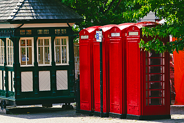
A charming scene featuring three iconic red telephone booths next to a vintage green kiosk. The booths are bright and well-maintained, surrounded by lush greenery and a hint of urban life.
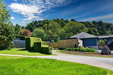
A well-maintained garden with a winding gravel path, neatly trimmed hedges, and a modern house surrounded by lush greenery under a blue sky with scattered clouds, United Kingdom, Europe
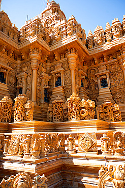
Well maintained golden Taranga Vihar Dham Tirth, a sacred Hindu pilgrimage site, India
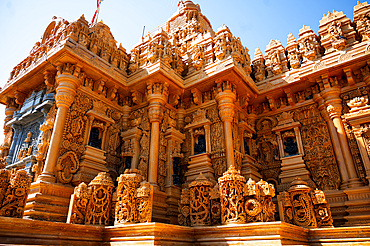
Well maintained golden Taranga Vihar Dham Tirth, a sacred Hindu pilgrimage site, India
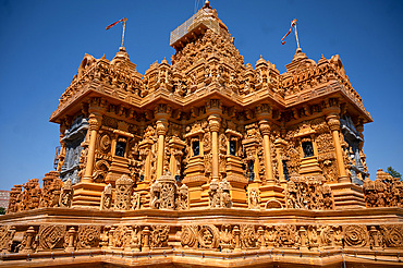
Well maintained golden Taranga Vihar Dham Tirth, a sacred Hindu pilgrimage site, India
A charming stone cottage with a slate roof, surrounded by lush greenery and a well-maintained garden. The sky is bright with scattered clouds, adding to the picturesque scene.
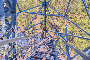
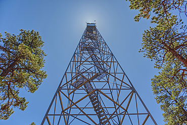
View from the 80 foot tall historic Fire Watchtower at Jacob Lake Arizona. Maintained as a historic landmark by the National Forest Service. No property release needed.
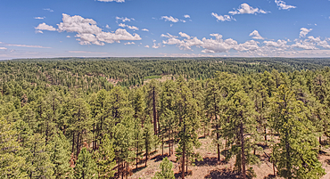
View from the 80 foot tall historic Fire Watchtower at Jacob Lake Arizona. Maintained as a historic landmark by the National Forest Service. No property release needed.
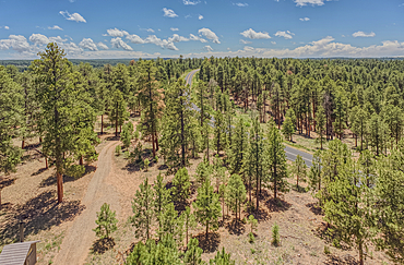
View from the 80 foot tall historic Fire Watchtower at Jacob Lake Arizona. Maintained as a historic landmark by the National Forest Service. No property release needed.
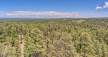
View from the 80 foot tall historic Fire Watchtower at Jacob Lake Arizona. Maintained as a historic landmark by the National Forest Service. No property release needed.
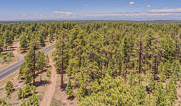
View from the 80 foot tall historic Fire Watchtower at Jacob Lake Arizona. Maintained as a historic landmark by the National Forest Service. No property release needed.
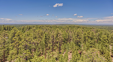
View from the 80 foot tall historic Fire Watchtower at Jacob Lake Arizona. Maintained as a historic landmark by the National Forest Service. No property release needed.
The 80 foot tall historic Fire Watchtower at Jacob Lake Arizona. Maintained as a historic landmark by the National Forest Service. No property release needed.

The 80 foot tall historic Fire Watchtower at Jacob Lake Arizona. Maintained as a historic landmark by the National Forest Service. No property release needed.
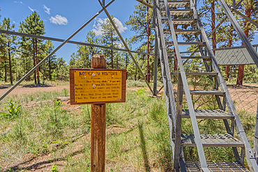
The 80 foot tall historic Fire Watchtower at Jacob Lake Arizona. Sign warns to climb the tower at your own risk. Maintained as a historic landmark by the National Forest Service. No property release needed.
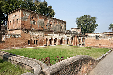
Lucknow Residency 18th century main building maintained as it was after the 1857 Seige with cannon shot marks, Lucknow, Uttar Pradesh, India, Asia

C17 transport plane and ground support at RAF Brize Norton in Oxfordshire, United Kingdom

The famous Painted Ladies, well maintained old Victorian houses on Alamo Square, San Francisco, California, United States of America, North America

The famous Painted Ladies, well maintained old Victorian houses on Alamo Square, with the skyscrapers of the Financial district beyond, San Francisco, California, United States of America, North America

Nicely maintained housing facade, San Francisco, California, United States of America, North America

The famous Painted Ladies, well maintained old Victorian houses on Alamo Square, with the skyscrapers of the Financial district beyond, San Francisco, California, United States of America, North America
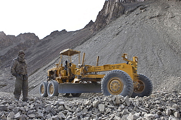
The road, for the most part, is a painstakingly handmade affair built and maintained by labourers from bihar state of india. They are subjected to excruciating and extremely dangerous working conditions. The workers are woefully ill-equipped and under-dressed and although the army purports to lend them winter clothing suitable for the extremity of the weather at these altitudes, many of the workers were visibly suffering from the cold. Ladkha, india
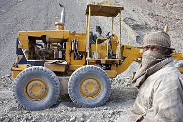
The road, for the most part, is a painstakingly handmade affair built and maintained by labourers from bihar state of india. They are subjected to excruciating and extremely dangerous working conditions. The workers are woefully ill-equipped and under-dressed and although the army purports to lend them winter clothing suitable for the extremity of the weather at these altitudes, many of the workers were visibly suffering from the cold. Ladkha, india
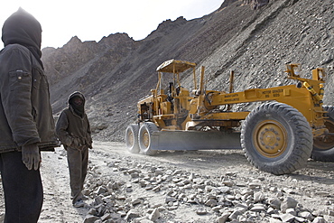
The road, for the most part, is a painstakingly handmade affair built and maintained by labourers from bihar state of india. They are subjected to excruciating and extremely dangerous working conditions. The workers are woefully ill-equipped and under-dressed and although the army purports to lend them winter clothing suitable for the extremity of the weather at these altitudes, many of the workers were visibly suffering from the cold. Ladkha, india
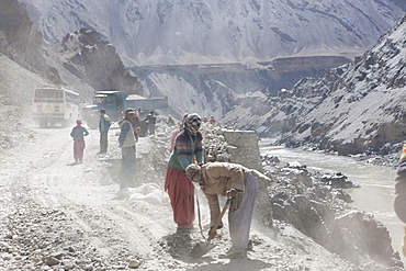
The road, for the most part, is a painstakingly handmade affair built and maintained by labourers from bihar state of india. They are subjected to excruciating and extremely dangerous working conditions. The workers are woefully ill-equipped and under-dressed and although the army purports to lend them winter clothing suitable for the extremity of the weather at these altitudes, many of the workers were visibly suffering from the cold. Ladakh, india

France, Alps In Winter, Overview On Mountains At Dusk, Ski Trail At Fore Being Maintained

On the roof of a Mosque in Kampala, you can see suburbs in the background. Well maintained and regularly painted. Kampala, Uganda, East Africa
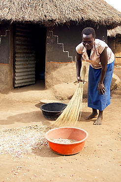
An IDP camp (internally displaced people) in Te-Tugu district of Northern Uganda has been created to accommodate the mass of Ugandan refugees fleeing the LRA (Lords Resistance Army) who are fighting the Ugandan government and its people. Although accommodation is basic- mainly mud huts, they are impeccably maintained, instilling a real sense of pride in the community. Te-Tugu, Uganda, East Africa
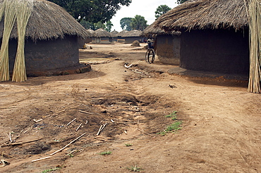
An IDP camp (internally displaced people) in Te-Tugu district of Northern Uganda has been created to accommodate the mass of Ugandan refugees fleeing the LRA (Lords Resistance Army) who are fighting the Ugandan government and its people. Although accommodation is basic- mainly mud huts, they are impeccably maintained, instilling a real sense of pride in the community. Te-Tugu, Uganda, East Africa
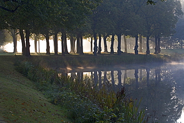
Graft, tree lines, fog, Great Garden Herrenhausen in Hanover, Hanover, Lower Saxony, northern Germany
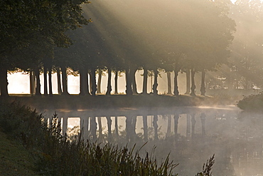
Graft, tree lines, fog, Great Garden Herrenhausen in Hanover, Hanover, Lower Saxony, northern Germany
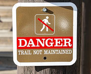
Sign Danger, Trail not maintained, signpost, road not maintained, Yellowstone National Park, Wyoming, USA, North America
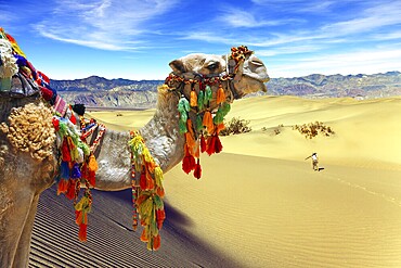
Orange sunrise in the desert. Well-groomed camel, decorated with colourful garlands and tassels, stands atop the sand dunes. Concept of active, ecological and photo tourism
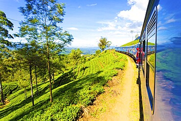
Tea plantation view and neat green tea plants seen from side exterior of passenger train curving ahead in hill country on a blue sky day in Haputale, Sri Lanka. Horizontal

Beautiful African American woman with trendy makeup, rhinestones on her eyes and curly hair. Beauty face. Photo taken in the studio

Beautiful african american woman with classic makeup in a milk bath wearing a black bunny mask. Beauty face

Beautiful african american woman with classic makeup in milk bath. Beauty face

Beautiful African American woman with trendy makeup, rhinestones on her eyes and curly hair. Beauty face. Photo taken in the studio

Millennial handsome man looking in mirror, applying moisturizing after shaving cream on cheeks in bathroom, head shot close up. Well groomed young guy doing skincare morning routine after showering
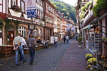
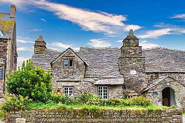
Old part of town, well-maintained timbered houses, Miltenberg, Bavaria, Germany
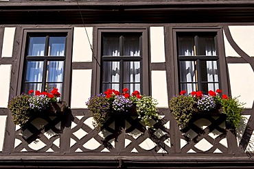
Old part of town, well-maintained timbered houses with flower boxes, Miltenberg, Bavaria, Germany
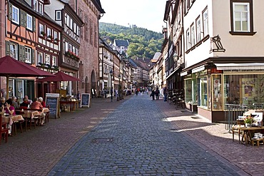
Old part of town, well-maintained timbered houses, Miltenberg, Bavaria, Germany
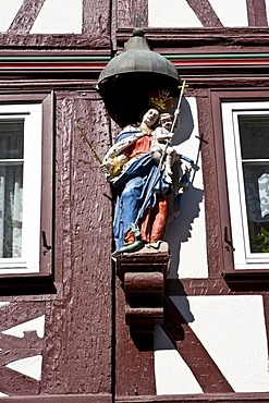
Old part of town, well-maintained timbered houses with carved figure, Miltenberg, Bavaria, Germany
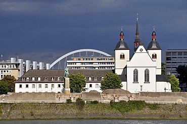
Monastery church of Alt St. Heribert, maintained by the Friends of Romanesque churches in Cologne, Deutz bank of the Rhine, Cologne, North Rhine-Westphalia, Germany, Europe
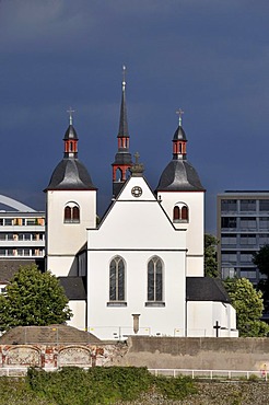
Monastery church of Alt St. Heribert, maintained by the Friends of Romanesque churches in Cologne, Deutz bank of the Rhine, Cologne, North Rhine-Westphalia, Germany, Europe

Nimoa Island - here the island mission will impress. The five-sided church features murals of island life and all mission buildings are surrounded by well maintained paths and gardens filled with flowering plants. Edged by jungle-covered mountains, postcard beaches and crystal clear waters - an island paradise indeed! The Louisiade Archipelago is a string of ten larger volcanic islands frequently fringed by coral reefs, and 90 smaller coral islands located 200 km southeast of New Guinea, stretching over more than 160 km and spread over an ocean area of 26,000 km? between the Solomon Sea to the north and the Coral Sea to the south. The aggregate land area of the islands is about 1,790 km? (690 square miles), with Vanatinai (formerly Sudest or Tagula as named by European claimants on Western maps) being the largest. Sideia Island and Basilaki Island lie closest to New Guinea, while Misima, Vanatinai, and Rossel islands lie further east. The archipelago is divided into the Local Level Government (LLG) areas Loui!

Nimoa Island - here the island mission will impress. The five-sided church features murals of island life and all mission buildings are surrounded by well maintained paths and gardens filled with flowering plants. Edged by jungle-covered mountains, postcard beaches and crystal clear waters - an island paradise indeed! The Louisiade Archipelago is a string of ten larger volcanic islands frequently fringed by coral reefs, and 90 smaller coral islands located 200 km southeast of New Guinea, stretching over more than 160 km and spread over an ocean area of 26,000 km? between the Solomon Sea to the north and the Coral Sea to the south. The aggregate land area of the islands is about 1,790 km? (690 square miles), with Vanatinai (formerly Sudest or Tagula as named by European claimants on Western maps) being the largest. Sideia Island and Basilaki Island lie closest to New Guinea, while Misima, Vanatinai, and Rossel islands lie further east. The archipelago is divided into the Local Level Government (LLG) areas Loui!

Nimoa Island - here the island mission will impress. The five-sided church features murals of island life and all mission buildings are surrounded by well maintained paths and gardens filled with flowering plants. Edged by jungle-covered mountains, postcard beaches and crystal clear waters - an island paradise indeed! The Louisiade Archipelago is a string of ten larger volcanic islands frequently fringed by coral reefs, and 90 smaller coral islands located 200 km southeast of New Guinea, stretching over more than 160 km and spread over an ocean area of 26,000 km? between the Solomon Sea to the north and the Coral Sea to the south. The aggregate land area of the islands is about 1,790 km? (690 square miles), with Vanatinai (formerly Sudest or Tagula as named by European claimants on Western maps) being the largest. Sideia Island and Basilaki Island lie closest to New Guinea, while Misima, Vanatinai, and Rossel islands lie further east. The archipelago is divided into the Local Level Government (LLG) areas Louisiade Rural (western part, with Misima), and Yaleyamba (western part, with Rossell and Tagula islands. The LLG areas are part of Samarai-Murua District district of Milne Bay. The seat of the Louisiade Rural LLG is Bwagaoia on Misima Island, the population center of the archipelago.
Nimoa Island - here the island mission will impress. The five-sided church features murals of island life and all mission buildings are surrounded by well maintained paths and gardens filled with flowering plants. Edged by jungle-covered mountains, postcard beaches and crystal clear waters - an island paradise indeed! The Louisiade Archipelago is a string of ten larger volcanic islands frequently fringed by coral reefs, and 90 smaller coral islands located 200 km southeast of New Guinea, stretching over more than 160 km and spread over an ocean area of 26,000 km? between the Solomon Sea to the north and the Coral Sea to the south. The aggregate land area of the islands is about 1,790 km? (690 square miles), with Vanatinai (formerly Sudest or Tagula as named by European claimants on Western maps) being the largest. Sideia Island and Basilaki Island lie closest to New Guinea, while Misima, Vanatinai, and Rossel islands lie further east.

Nimoa Island - here the island mission will impress. The five-sided church features murals of island life and all mission buildings are surrounded by well maintained paths and gardens filled with flowering plants. Edged by jungle-covered mountains, postcard beaches and crystal clear waters - an island paradise indeed! The Louisiade Archipelago is a string of ten larger volcanic islands frequently fringed by coral reefs, and 90 smaller coral islands located 200 km southeast of New Guinea, stretching over more than 160 km and spread over an ocean area of 26,000 km? between the Solomon Sea to the north and the Coral Sea to the south. The aggregate land area of the islands is about 1,790 km? (690 square miles), with Vanatinai (formerly Sudest or Tagula as named by European claimants on Western maps) being the largest. Sideia Island and Basilaki Island lie closest to New Guinea, while Misima, Vanatinai, and Rossel islands lie further east. The archipelago is divided into the Local Level Government (LLG) areas Louisiade Rural (western part, with Misima), and Yaleyamba (western part, with Rossell and Tagula islands. The LLG areas are part of Samarai-Murua District district of Milne Bay. The seat of the Louisiade Rural LLG is Bwagaoia on Misima Island, the population center of the archipelago.

Nimoa Island - here the island mission will impress. The five-sided church features murals of island life and all mission buildings are surrounded by well maintained paths and gardens filled with flowering plants. Edged by jungle-covered mountains, postcard beaches and crystal clear waters - an island paradise indeed! The Louisiade Archipelago is a string of ten larger volcanic islands frequently fringed by coral reefs, and 90 smaller coral islands located 200 km southeast of New Guinea, stretching over more than 160 km and spread over an ocean area of 26,000 km? between the Solomon Sea to the north and the Coral Sea to the south. The aggregate land area of the islands is about 1,790 km? (690 square miles), with Vanatinai (formerly Sudest or Tagula as named by European claimants on Western maps) being the largest. Sideia Island and Basilaki Island lie closest to New Guinea, while Misima, Vanatinai, and Rossel islands lie further east. The archipelago is divided into the Local Level Government (LLG) areas Louisiade Rural (western part, with Misima), and Yaleyamba (western part, with Rossell and Tagula islands. The LLG areas are part of Samarai-Murua District district of Milne Bay. The seat of the Louisiade Rural LLG is Bwagaoia on Misima Island, the population center of the archipelago.

Nimoa Island - here the island mission will impress. The five-sided church features murals of island life and all mission buildings are surrounded by well maintained paths and gardens filled with flowering plants. Edged by jungle-covered mountains, postcard beaches and crystal clear waters - an island paradise indeed! The Louisiade Archipelago is a string of ten larger volcanic islands frequently fringed by coral reefs, and 90 smaller coral islands located 200 km southeast of New Guinea, stretching over more than 160 km and spread over an ocean area of 26,000 km? between the Solomon Sea to the north and the Coral Sea to the south. The aggregate land area of the islands is about 1,790 km? (690 square miles), with Vanatinai (formerly Sudest or Tagula as named by European claimants on Western maps) being the largest. Sideia Island and Basilaki Island lie closest to New Guinea, while Misima, Vanatinai, and Rossel islands lie further east. The archipelago is divided into the Local Level Government (LLG) areas Loui!
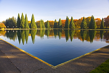
Pond In Eastmorland Park, Portland, Oregon, Usa
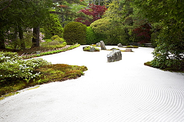
Zen garden

Multiplication of an orchid by tuft division

Make a Amaryllis (Hippeastrum sp) bloom again. 4 Fertilize

Multiplication of an orchid by tuft division

Multiplication of an orchid by tuft division
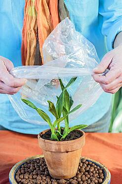
Multiplication of an orchid by tuft division

Make a Amaryllis (Hippeastrum sp) bloom again. 5 Divide
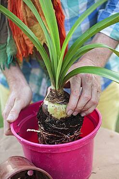
Make a Amaryllis (Hippeastrum sp) bloom again. 3 Repot

Make a Amaryllis (Hippeastrum sp) bloom again. 2. The bulb participates in photosynthesis when exposed to light.

Woman pruning a lavender, a lavandine having finished flowering.
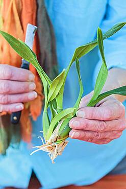
Multiplication of an orchid by tuft division