Results
20 results found
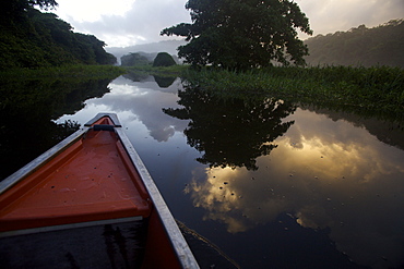
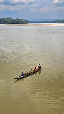
Boating and observing fauna and flora in the everglade area of Kaw, French Guiana, South America
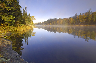
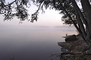
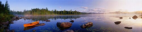
Misty morning on Hoe Lake, Boundary Waters Canoe Area Wilderness, Superior National Forest, Minnesota, United States of America, North America
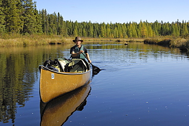
Canoeing on Hoe Lake, Boundary Waters Canoe Area Wilderness, Superior National Forest, Minnesota, United States of America, North America
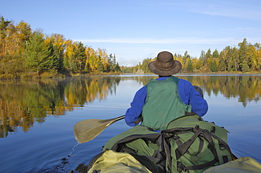
Canoeing on the Louse River, Boundary Waters Canoe Area Wilderness, Superior National Forest, Minnesota, United States of America, North America
Locals in a canoe on the Sangha river, Dzanga Sangha National Park, UNESCO, Central African Republic

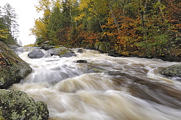
Waterfall, Louse River, Boundary Waters Canoe Area Wilderness, Superior National Forest, Minnesota, United States of America, North America
Rapids between Mora Lake and Little Saganaga Lake, Boundary Waters Canoe Area Wilderness, Superior National Forest, Minnesota, United States of America, North America
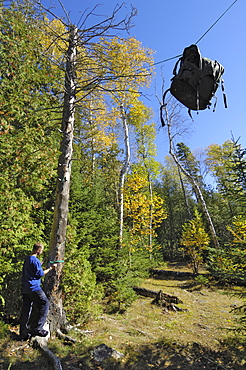
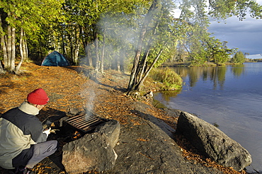
Bear Hang, food bag hung between two trees to protect it from bears, Boundary Waters Canoe Area Wilderness, Superior National Forest, Minnesota, United States of America, North America
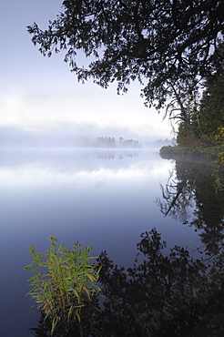
Misty morning, Malberg Lake, Boundary Waters Canoe Area Wilderness, Superior National Forest, Minnesota, United States of America, North America
Camp on Malberg Lake, Boundary Waters Canoe Area Wilderness, Superior National Forest, Minnesota, United States of America, North America
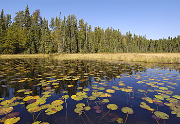
Water lilies on the Frost River, Boundary Waters Canoe Area Wilderness, Superior National Forest, Minnesota, United States of America, North America
Misty morning, Malberg Lake, Boundary Waters Canoe Area Wilderness, Superior National Forest, Minnesota, United States of America, North America
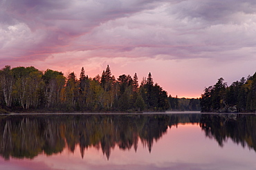
Sunset over Malberg Lake, Boundary Waters Canoe Area Wilderness, Superior National Forest, Minnesota, United States of America, North America
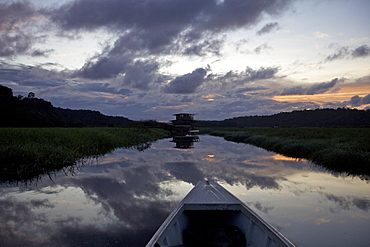
Boating and observing fauna and flora in the everglade area of Kaw, and floating lodge of the marsh in background, French Guiana, South America
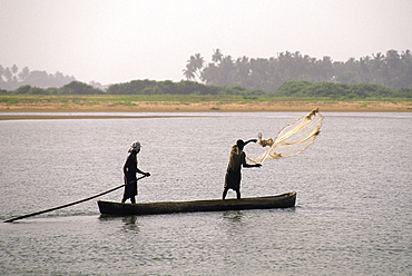
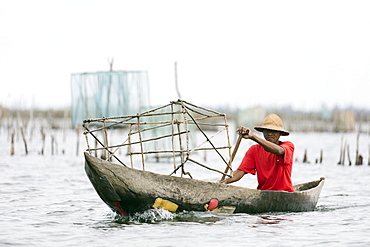
Canoe net fishermen on Mono River mouth in Grand-Popo area, Benin,Gulf of Guinea,West Africa
Windham Bay and the Chuck River Wilderness Area, Southeast Alaska, United States of America, North America
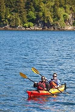
Kayaking in Windham Bay in the Chuck River Wilderness Area, Southeast Alaska, United States of America, North America
Pangalanes Lakes canal system, fishing nets, Tamatave, eastern area, Madagascar, Africa

Dug out canoe on the River Nile at Mongala, southern area, Sudan, Africa
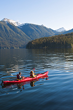
Kayaking in Windham Bay in the Chuck River Wilderness Area, Southeast Alaska, United States of America, North America

Guam, Micronesia: outrigger canoe paddlers at sunset at Tumon Bay resort area.
Wild Pond North Hudson Area Adirondacks NY

Family in paddle boat, Moraine Lake, Banff National Park, Alberta, Canada
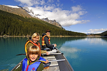
Family in paddle boat, Moraine Lake, Banff National Park, Alberta, Canada

Tam Coc region near Ninh Binh, dry Halong Bay, Vietnam, Southeast Asia, Asia
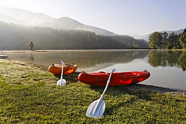
2 kayaks at the bathing lake and camping area Zenz near the mountain Hochschwab, Pichl-Grossdorf, Styria, Austria
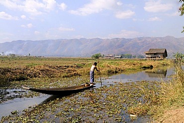
Intha Man with a canoe surrounded by Common Water Hyacinth (Eichhornia crassipes), Inle Lake, Shan State, Myanmar, Southeast Asia, Asia
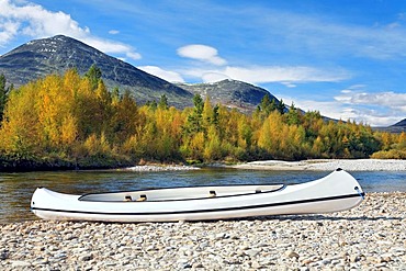
Canoe on the Atna river bank in Rondane National Park, Norway, Scandinavia, Europe

Local paddling in wooden canoe, Volta River, Ghana, Africa
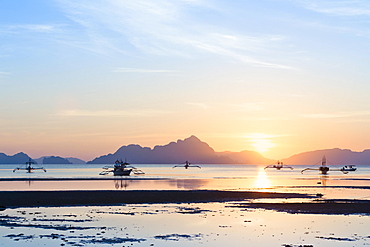
Sunset view from Corong Corong beach near El Nido, Bacuit archipelago, Palawan island, Philippines, Asia
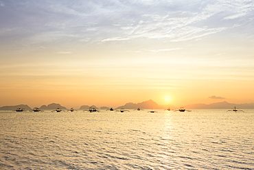
Outrigger canoes at sunset, view from Corong Corong beach near El Nido, Bacuit archipelago, Palawan island, Philippines, Asia
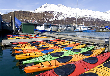
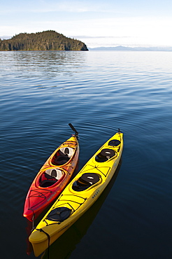
Sea kayaks, Valdez Small Boat Harbour, Prince William Sound, Alaska, USA

Camp on gravel bar, tent and canoe, Pelly Mountains behind, upper Liard River, Yukon Territory, Canada
Two men in a canoe, canoeists paddling, canoeing upper Liard River, Pelly Mountains behind, Yukon Territory, Canada, North America
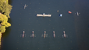
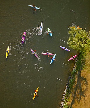
Aerial view, boat race, regatta on the Ruhr river, Essen-Kettwig, Essen, Ruhrgebiet region, North Rhine-Westphalia, Germany, Europe

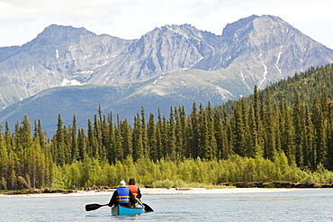
Canoeists on the Wind River, canoeing, paddling a canoe, Northern Mackenzie Mountains behind, Yukon Territory, Canada
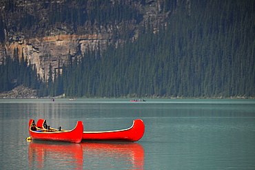
Canoe on Moraine Lake, Valley of the Ten Peaks, Banff National Park, Canadian Rockies, Alberta, Canada
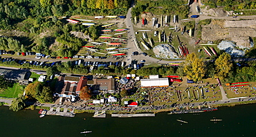
Aerial view, boat race, regatta on the Ruhr river, Essen-Kettwig, Essen, Ruhrgebiet region, North Rhine-Westphalia, Germany, Europe

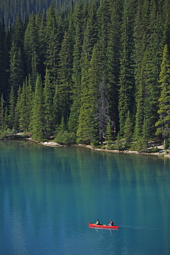
Tourists in a canoe, Lake Louise, Banff National Park, Canadian Rocky Mountains, Alberta, Canada
Historic Native American canoes, Lake Louise, Banff National Park, Canadian Rocky Mountains, Alberta, Canada
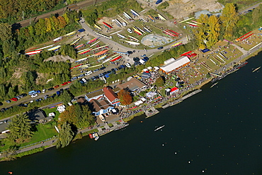
Aerial view, boat race, regatta on the Ruhr river, Essen-Kettwig, Essen, Ruhrgebiet region, North Rhine-Westphalia, Germany, Europe
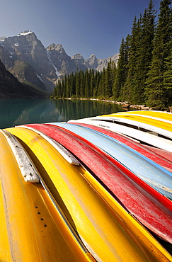
Canoes on Moraine Lake, Valley of the Ten Peaks, Banff National Park, Canadian Rockies, Alberta, Canada
Aerial view, Hohenlimburg district, Hagen, Ruhrgebiet area, North Rhine-Westphalia, Germany, Europe

Nimoa Island - here the island mission will impress. The five-sided church features murals of island life and all mission buildings are surrounded by well maintained paths and gardens filled with flowering plants. Edged by jungle-covered mountains, postcard beaches and crystal clear waters - an island paradise indeed! The Louisiade Archipelago is a string of ten larger volcanic islands frequently fringed by coral reefs, and 90 smaller coral islands located 200 km southeast of New Guinea, stretching over more than 160 km and spread over an ocean area of 26,000 km? between the Solomon Sea to the north and the Coral Sea to the south. The aggregate land area of the islands is about 1,790 km? (690 square miles), with Vanatinai (formerly Sudest or Tagula as named by European claimants on Western maps) being the largest. Sideia Island and Basilaki Island lie closest to New Guinea, while Misima, Vanatinai, and Rossel islands lie further east. The archipelago is divided into the Local Level Government (LLG) areas Loui!

Nimoa Island - here the island mission will impress. The five-sided church features murals of island life and all mission buildings are surrounded by well maintained paths and gardens filled with flowering plants. Edged by jungle-covered mountains, postcard beaches and crystal clear waters - an island paradise indeed! The Louisiade Archipelago is a string of ten larger volcanic islands frequently fringed by coral reefs, and 90 smaller coral islands located 200 km southeast of New Guinea, stretching over more than 160 km and spread over an ocean area of 26,000 km? between the Solomon Sea to the north and the Coral Sea to the south. The aggregate land area of the islands is about 1,790 km? (690 square miles), with Vanatinai (formerly Sudest or Tagula as named by European claimants on Western maps) being the largest. Sideia Island and Basilaki Island lie closest to New Guinea, while Misima, Vanatinai, and Rossel islands lie further east. The archipelago is divided into the Local Level Government (LLG) areas Loui!

Nimoa Island - here the island mission will impress. The five-sided church features murals of island life and all mission buildings are surrounded by well maintained paths and gardens filled with flowering plants. Edged by jungle-covered mountains, postcard beaches and crystal clear waters - an island paradise indeed! The Louisiade Archipelago is a string of ten larger volcanic islands frequently fringed by coral reefs, and 90 smaller coral islands located 200 km southeast of New Guinea, stretching over more than 160 km and spread over an ocean area of 26,000 km? between the Solomon Sea to the north and the Coral Sea to the south. The aggregate land area of the islands is about 1,790 km? (690 square miles), with Vanatinai (formerly Sudest or Tagula as named by European claimants on Western maps) being the largest. Sideia Island and Basilaki Island lie closest to New Guinea, while Misima, Vanatinai, and Rossel islands lie further east. The archipelago is divided into the Local Level Government (LLG) areas Louisiade Rural (western part, with Misima), and Yaleyamba (western part, with Rossell and Tagula islands. The LLG areas are part of Samarai-Murua District district of Milne Bay. The seat of the Louisiade Rural LLG is Bwagaoia on Misima Island, the population center of the archipelago.
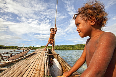
Children playing with a outrigger canoe in the village of Hessessai Bay at PanaTinai (Panatinane)island in the Louisiade Archipelago in Milne Bay Province, Papua New Guinea. The island has an area of 78 km2. The Louisiade Archipelago is a string of ten larger volcanic islands frequently fringed by coral reefs, and 90 smaller coral islands located 200 km southeast of New Guinea, stretching over more than 160 km and spread over an ocean area of 26,000 km? between the Solomon Sea to the north and the Coral Sea to the south. The aggregate land area of the islands is about 1,790 km? (690 square miles), with Vanatinai (formerly Sudest or Tagula as named by European claimants on Western maps) being the largest. Sideia Island and Basilaki Island lie closest to New Guinea, while Misima, Vanatinai, and Rossel islands lie further east. The archipelago is divided into the Local Level Government (LLG) areas Louisiade Rural (western part, with Misima), and Yaleyamba (western part, with Rossell and Tagula islands. The LLG areas are part of Samarai-Murua District district of Milne Bay. The seat of the Louisiade Rural LLG is Bwagaoia on Misima Island, the population center of the archipelago.PanaTinai (Panatinane) is an island in the Louisiade Archipelago in Milne Bay Province, Papua New Guinea.

Nimoa Island - here the island mission will impress. The five-sided church features murals of island life and all mission buildings are surrounded by well maintained paths and gardens filled with flowering plants. Edged by jungle-covered mountains, postcard beaches and crystal clear waters - an island paradise indeed! The Louisiade Archipelago is a string of ten larger volcanic islands frequently fringed by coral reefs, and 90 smaller coral islands located 200 km southeast of New Guinea, stretching over more than 160 km and spread over an ocean area of 26,000 km? between the Solomon Sea to the north and the Coral Sea to the south. The aggregate land area of the islands is about 1,790 km? (690 square miles), with Vanatinai (formerly Sudest or Tagula as named by European claimants on Western maps) being the largest. Sideia Island and Basilaki Island lie closest to New Guinea, while Misima, Vanatinai, and Rossel islands lie further east. The archipelago is divided into the Local Level Government (LLG) areas Louisiade Rural (western part, with Misima), and Yaleyamba (western part, with Rossell and Tagula islands. The LLG areas are part of Samarai-Murua District district of Milne Bay. The seat of the Louisiade Rural LLG is Bwagaoia on Misima Island, the population center of the archipelago.

Nimoa Island - here the island mission will impress. The five-sided church features murals of island life and all mission buildings are surrounded by well maintained paths and gardens filled with flowering plants. Edged by jungle-covered mountains, postcard beaches and crystal clear waters - an island paradise indeed! The Louisiade Archipelago is a string of ten larger volcanic islands frequently fringed by coral reefs, and 90 smaller coral islands located 200 km southeast of New Guinea, stretching over more than 160 km and spread over an ocean area of 26,000 km? between the Solomon Sea to the north and the Coral Sea to the south. The aggregate land area of the islands is about 1,790 km? (690 square miles), with Vanatinai (formerly Sudest or Tagula as named by European claimants on Western maps) being the largest. Sideia Island and Basilaki Island lie closest to New Guinea, while Misima, Vanatinai, and Rossel islands lie further east. The archipelago is divided into the Local Level Government (LLG) areas Louisiade Rural (western part, with Misima), and Yaleyamba (western part, with Rossell and Tagula islands. The LLG areas are part of Samarai-Murua District district of Milne Bay. The seat of the Louisiade Rural LLG is Bwagaoia on Misima Island, the population center of the archipelago.

Nimoa Island - here the island mission will impress. The five-sided church features murals of island life and all mission buildings are surrounded by well maintained paths and gardens filled with flowering plants. Edged by jungle-covered mountains, postcard beaches and crystal clear waters - an island paradise indeed! The Louisiade Archipelago is a string of ten larger volcanic islands frequently fringed by coral reefs, and 90 smaller coral islands located 200 km southeast of New Guinea, stretching over more than 160 km and spread over an ocean area of 26,000 km? between the Solomon Sea to the north and the Coral Sea to the south. The aggregate land area of the islands is about 1,790 km? (690 square miles), with Vanatinai (formerly Sudest or Tagula as named by European claimants on Western maps) being the largest. Sideia Island and Basilaki Island lie closest to New Guinea, while Misima, Vanatinai, and Rossel islands lie further east. The archipelago is divided into the Local Level Government (LLG) areas Loui!
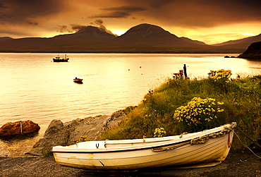
Boat On The Shore At Sunset, Island Of Islay, Scotland
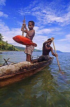
Fisherman on canoe Fergusson island Papua New Guinea
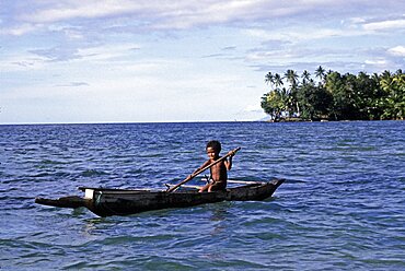
Boy and outrigger canoe Fergusson island Papua New Guinea