Results
22 results found

Church of Santa Chiara, Lecce, Salento, Apulia, Italy
Chiesa della Madonna del Carmine (Church of Our Lady of Mount Carmel), Manduria, Taranto, Apulia, Italy
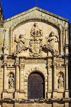
Co-cathedral of Ruvo di Puglia, Ruvo di Puglia, Bari, Apulia, Italy

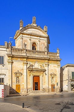
Church of San Ferdinando, Bari, Apulia, Italy
Church of San Vito a Mare, Mazara del Vallo, Trapani, Sicily, Italy, Mediterranean, Europe
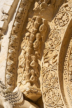
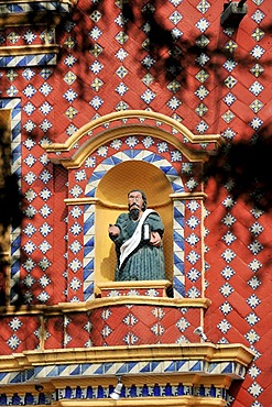
Santiago Apostol Church, detailed view, Tlatelolco Archaeological Site, Plaza de las Tres Culturas, Mexico City, Mexico
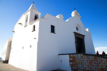
White church in Forio, Ischia, Phlegrean Islands, Gulf of Naples, Campania, Italy

View of a classic stave church preserved in the city of Oslo, Norway

Santo Domingo de Guzman Church, interior detailCity of Puebla, Puebla State, Mexico
The Church of Santo Domingo de Guzman, detailed view, Oaxaca de Juarez, Oaxaca State, Mexico
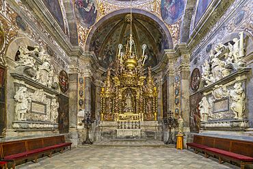
Interior of St. Paul's Cathedral, Mdina, Malta
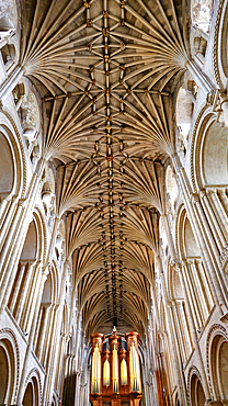
Interior, Norwich Cathedral, Norfolk, UK

Chapel of the Rosario, interior detail, Santo Domingo de Guzman Church, City of Puebla, Puebla State, Mexico
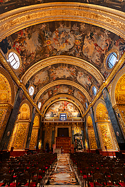
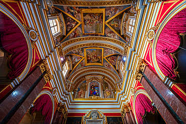
Interior of St. John's Co-Cathedral, UNESCO, Valletta, Malta
Brazzaville, Republic of Congo
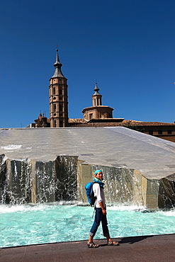
Woman beside water features of Plaza del Pilar, overlooking the Basilica de Nuestra Senora del Pilar, Zaragoza, Aragon, Spain

Book market, monument to Iwan Fyedorovich, Dominican church and monastery with Rocco Baroque and Classical features, Old Town, UNESCO World Heritage Site, Lviv, Ukraine, Europe
Altarpiece of the Most Pure, Metropolitan and Primatial Cathedral Basilica of Santa Thecla, Tarragona, Catalonia, Spain
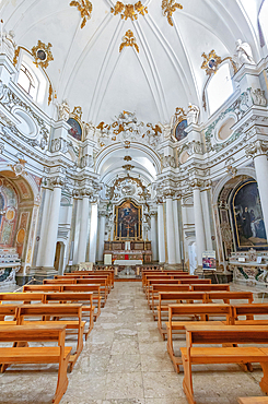
Chiesa di Santa Chiara interior, Noto, UNESCO, Noto Valley, Sicily, Italy
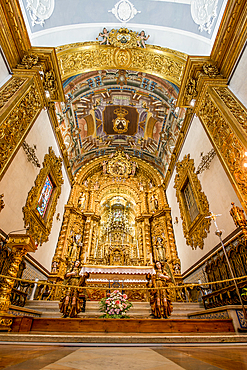
Church of the Third Order of Our Lady of Mount Carmel (Igreja da Ordem Terceira de Nossa Senhora do Monte do Carmo), Faro, Algarve, Portugal
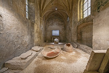
Church of St-Honorat, Alyscamps, Arles, Bouches du Rhone, Provence-Alpes-Cote d'Azur, France
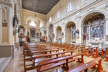
Church of San Domenico, Pisanelli Square, Tricase, Lecce, Salento, Apulia, Italy, Europe
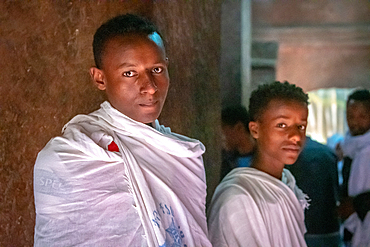
A pair of young men in shawls inside of Bet Giyorgis (Church of St. George) in Lalibela, Ethiopia

Portrait of an Ethiopian woman outside of the rock hewn monolithic church of Bet Maryam (Church of St. Mary) in Lalibela, Ethiopia
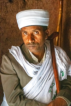
Portrait of a man inside the rock hewn monolithic church of Bet Giyorgis (Church of St. George) in Lalibela, Ethiopia
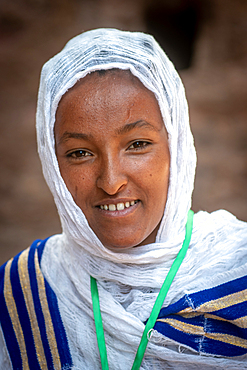
Portrait of an Ethiopian woman outside of Bet Medhane Alem (Church of the World Savior) in Lalibela, Ethiopia
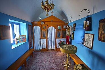
The interior of the church features icons and decorative elements in blue and orange, chapel, church, Agios Isidoros, rocky islet, Gourna Bay, Kokkali, Leros, Dodecanese, Greek Islands, Greece
Statue of an evangelist with indigenous features in the facade of the church of Iglesia Santa Maria de Tonantzintla, San Pedro Cholula, Puebla, Mexico, Latin America, North America

The steeples of St. Florin Church in Koblenz, Rhineland-Pfalatinate Germany
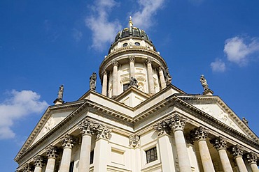
French Dome, Gendarme market, Friedrichstadt, Berlin, Germany, Europe
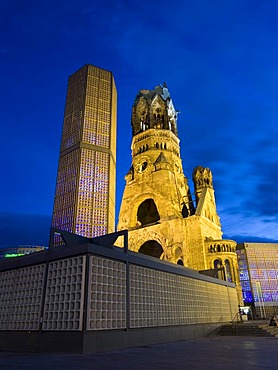
Emperor Wilhelm memory church at Breitscheidplatz, Kurfurstendamm at night, Berlin, Germany, Europe
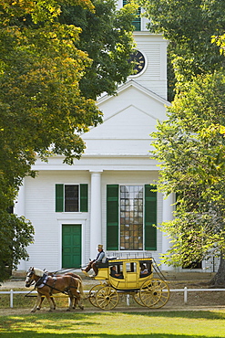
A living museum recreating colonial life in New England, Old Sturbridge Village in Sturbridge, features an authentic stagecoach from the period which visitors can ride..

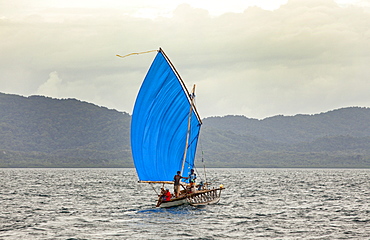
Nimoa Island - here the island mission will impress. The five-sided church features murals of island life and all mission buildings are surrounded by well maintained paths and gardens filled with flowering plants. Edged by jungle-covered mountains, postcard beaches and crystal clear waters - an island paradise indeed! The Louisiade Archipelago is a string of ten larger volcanic islands frequently fringed by coral reefs, and 90 smaller coral islands located 200 km southeast of New Guinea, stretching over more than 160 km and spread over an ocean area of 26,000 km? between the Solomon Sea to the north and the Coral Sea to the south. The aggregate land area of the islands is about 1,790 km? (690 square miles), with Vanatinai (formerly Sudest or Tagula as named by European claimants on Western maps) being the largest. Sideia Island and Basilaki Island lie closest to New Guinea, while Misima, Vanatinai, and Rossel islands lie further east. The archipelago is divided into the Local Level Government (LLG) areas Loui!

Nimoa Island - here the island mission will impress. The five-sided church features murals of island life and all mission buildings are surrounded by well maintained paths and gardens filled with flowering plants. Edged by jungle-covered mountains, postcard beaches and crystal clear waters - an island paradise indeed! The Louisiade Archipelago is a string of ten larger volcanic islands frequently fringed by coral reefs, and 90 smaller coral islands located 200 km southeast of New Guinea, stretching over more than 160 km and spread over an ocean area of 26,000 km? between the Solomon Sea to the north and the Coral Sea to the south. The aggregate land area of the islands is about 1,790 km? (690 square miles), with Vanatinai (formerly Sudest or Tagula as named by European claimants on Western maps) being the largest. Sideia Island and Basilaki Island lie closest to New Guinea, while Misima, Vanatinai, and Rossel islands lie further east. The archipelago is divided into the Local Level Government (LLG) areas Loui!

Nimoa Island - here the island mission will impress. The five-sided church features murals of island life and all mission buildings are surrounded by well maintained paths and gardens filled with flowering plants. Edged by jungle-covered mountains, postcard beaches and crystal clear waters - an island paradise indeed! The Louisiade Archipelago is a string of ten larger volcanic islands frequently fringed by coral reefs, and 90 smaller coral islands located 200 km southeast of New Guinea, stretching over more than 160 km and spread over an ocean area of 26,000 km? between the Solomon Sea to the north and the Coral Sea to the south. The aggregate land area of the islands is about 1,790 km? (690 square miles), with Vanatinai (formerly Sudest or Tagula as named by European claimants on Western maps) being the largest. Sideia Island and Basilaki Island lie closest to New Guinea, while Misima, Vanatinai, and Rossel islands lie further east. The archipelago is divided into the Local Level Government (LLG) areas Louisiade Rural (western part, with Misima), and Yaleyamba (western part, with Rossell and Tagula islands. The LLG areas are part of Samarai-Murua District district of Milne Bay. The seat of the Louisiade Rural LLG is Bwagaoia on Misima Island, the population center of the archipelago.
Nimoa Island - here the island mission will impress. The five-sided church features murals of island life and all mission buildings are surrounded by well maintained paths and gardens filled with flowering plants. Edged by jungle-covered mountains, postcard beaches and crystal clear waters - an island paradise indeed! The Louisiade Archipelago is a string of ten larger volcanic islands frequently fringed by coral reefs, and 90 smaller coral islands located 200 km southeast of New Guinea, stretching over more than 160 km and spread over an ocean area of 26,000 km? between the Solomon Sea to the north and the Coral Sea to the south. The aggregate land area of the islands is about 1,790 km? (690 square miles), with Vanatinai (formerly Sudest or Tagula as named by European claimants on Western maps) being the largest. Sideia Island and Basilaki Island lie closest to New Guinea, while Misima, Vanatinai, and Rossel islands lie further east.

Nimoa Island - here the island mission will impress. The five-sided church features murals of island life and all mission buildings are surrounded by well maintained paths and gardens filled with flowering plants. Edged by jungle-covered mountains, postcard beaches and crystal clear waters - an island paradise indeed! The Louisiade Archipelago is a string of ten larger volcanic islands frequently fringed by coral reefs, and 90 smaller coral islands located 200 km southeast of New Guinea, stretching over more than 160 km and spread over an ocean area of 26,000 km? between the Solomon Sea to the north and the Coral Sea to the south. The aggregate land area of the islands is about 1,790 km? (690 square miles), with Vanatinai (formerly Sudest or Tagula as named by European claimants on Western maps) being the largest. Sideia Island and Basilaki Island lie closest to New Guinea, while Misima, Vanatinai, and Rossel islands lie further east. The archipelago is divided into the Local Level Government (LLG) areas Louisiade Rural (western part, with Misima), and Yaleyamba (western part, with Rossell and Tagula islands. The LLG areas are part of Samarai-Murua District district of Milne Bay. The seat of the Louisiade Rural LLG is Bwagaoia on Misima Island, the population center of the archipelago.

Nimoa Island - here the island mission will impress. The five-sided church features murals of island life and all mission buildings are surrounded by well maintained paths and gardens filled with flowering plants. Edged by jungle-covered mountains, postcard beaches and crystal clear waters - an island paradise indeed! The Louisiade Archipelago is a string of ten larger volcanic islands frequently fringed by coral reefs, and 90 smaller coral islands located 200 km southeast of New Guinea, stretching over more than 160 km and spread over an ocean area of 26,000 km? between the Solomon Sea to the north and the Coral Sea to the south. The aggregate land area of the islands is about 1,790 km? (690 square miles), with Vanatinai (formerly Sudest or Tagula as named by European claimants on Western maps) being the largest. Sideia Island and Basilaki Island lie closest to New Guinea, while Misima, Vanatinai, and Rossel islands lie further east. The archipelago is divided into the Local Level Government (LLG) areas Louisiade Rural (western part, with Misima), and Yaleyamba (western part, with Rossell and Tagula islands. The LLG areas are part of Samarai-Murua District district of Milne Bay. The seat of the Louisiade Rural LLG is Bwagaoia on Misima Island, the population center of the archipelago.

Nimoa Island - here the island mission will impress. The five-sided church features murals of island life and all mission buildings are surrounded by well maintained paths and gardens filled with flowering plants. Edged by jungle-covered mountains, postcard beaches and crystal clear waters - an island paradise indeed! The Louisiade Archipelago is a string of ten larger volcanic islands frequently fringed by coral reefs, and 90 smaller coral islands located 200 km southeast of New Guinea, stretching over more than 160 km and spread over an ocean area of 26,000 km? between the Solomon Sea to the north and the Coral Sea to the south. The aggregate land area of the islands is about 1,790 km? (690 square miles), with Vanatinai (formerly Sudest or Tagula as named by European claimants on Western maps) being the largest. Sideia Island and Basilaki Island lie closest to New Guinea, while Misima, Vanatinai, and Rossel islands lie further east. The archipelago is divided into the Local Level Government (LLG) areas Loui!
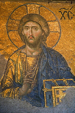
Religious Mosaic, Istanbul, Turkey
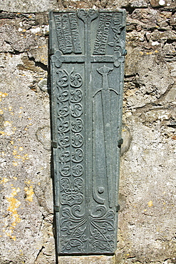
Clonca Church, Clonca, County Donegal, Ireland