Results
4 results found
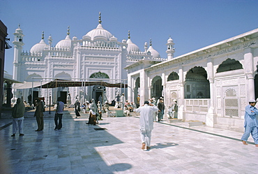
Data Durbar Shrine, Lahore, Pakistan
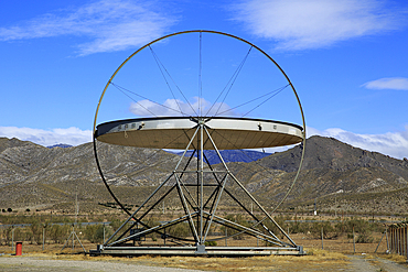
Large heliostat EuroDish solar energy scientific research centre, Tabernas, Almeria, Andalusia, Spain, Europe
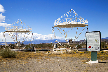
Parabolic discs at the solar energy scientific research centre, Tabernas, Almeria, Andalusia, Spain, Europe

AI generated image of a Group of humanoid robots working on computers in a data center
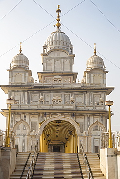
Gurudwara Data Bhandhi Chhod Shikh Temple, Gwalior Fort, Gwalior, Madhya Pradesh, India, Asia
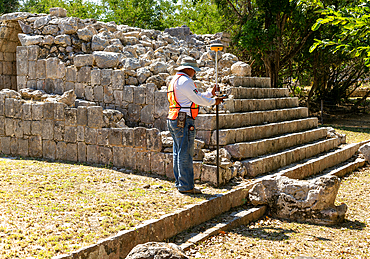
Surveyor at work, Temple of Panels (Templo de los Tableros Esculpidos), Mayan ruins, Chichen Itza, UNESCO World Heritage Site, Yucatan, Mexico, North America
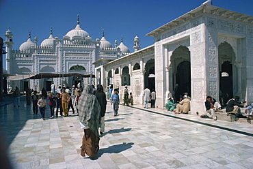
Groups of people at the Data Durbar Shrine in Lahore, Pakistan, Asia
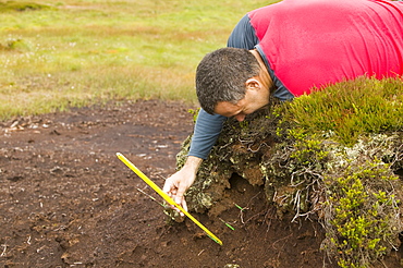
A scientist looking at peat erosion in the north Pennines, Cumbria, England, United Kingdom, Europe
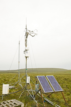
Scientific instruments to measure the carbon balance from peat bogs which is changing due to climate change in the north Pennines at Moorhouse, Cumbria, England, United Kingdom, Europe
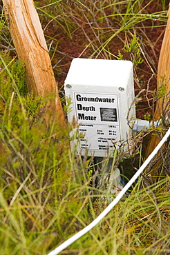
Scientific instruments to measure the carbon balance from peat bogs which is changing due to climate change in the north Pennines at Moorhouse, Cumbria, England, United Kingdom, Europe
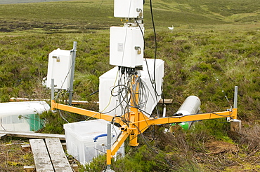
Scientific instruments to measure the carbon balance from peat bogs which is changing due to climate change in the north Pennines at Moorhouse, Cumbria, England, United Kingdom, Europe
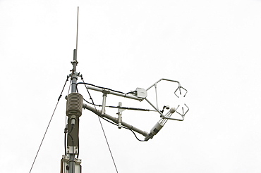
Scientific instruments to measure the carbon balance from peat bogs which is changing due to climate change in the north Pennines at Moorhouse, Cumbria, England, United Kingdom, Europe
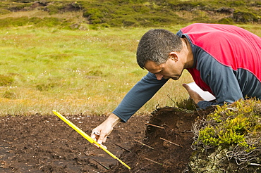
A scientist looking at peat erosion in the north Pennines, Cumbria, England, United Kingdom, Europe

Caucasian scientist using digital tablet in greenhouse

Caucasian scientist using digital tablet in greenhouse

Technicians examining computer in server room

Hispanic technician checking technology in server room

Hispanic technician using computer in server room
Technician using digital tablet in server room

Mixed race technician holding digital tablet in server room

Mixed race technician using digital tablet in server room

Close up of computer keyboard, files and cell phone on office desk

Mixed race scientist pipetting liquid into test tubes in laboratory

Technicians walking in server room

Mixed race scientist dropping leaf in test tube

Blurred view of technicians pushing cart in server room

Close up of computer keyboard, files, cell phone and eyeglasses on office desk

Mixed race scientist using digital tablet in laboratory

Mixed race technician examining computer in server room

Caucasian scientist using digital tablet in greenhouse

Mixed Race woman texting on cell phone near computer

Circuit board in x-ray of skull
Departure schedule at airport

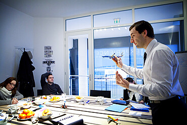
Business people meeting in office

Business people talking about paperwork on wall

Mixed race security guard watching monitors in control room

Mixed race scientist using digital tablet in laboratory
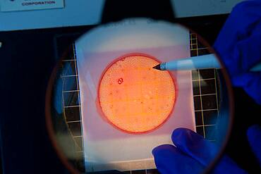
Scientist counting cultures on a petri dish

Scientist counting cultures on a petri dish
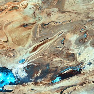
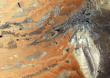
Great Salt Desert, Landsat 7

Europe, Sentinel-3A satellite image
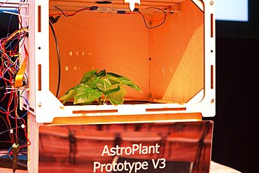
AstroPlant desktop greenhouse space research
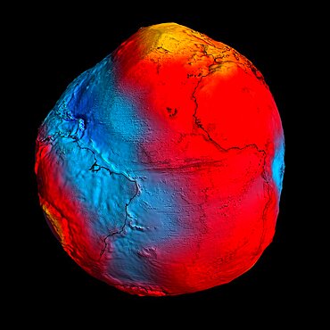
Earth's Geoid
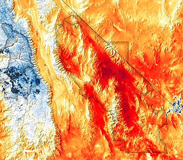
Hottest Temperatures Recorded at Death Valley, Satellite Data Map
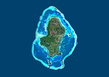
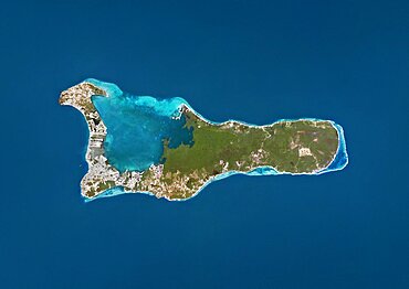
Satellite view of Wallis Island, part of Wallis and Futuna Islands. This image was compiled from data acquired by Landsat 8 satellite in 2014.

Satellite view of Cuba and Jamaica. This image was compiled from data acquired by Landsat satellites.
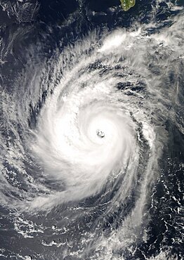
Hurricane Norbert, Pacific Ocean, In 2008, True Colour Satellite Image. Hurricane Norbert on 8 October 2008 over the Pacific ocean off Mexico. True-colour satellite image using MODIS data.
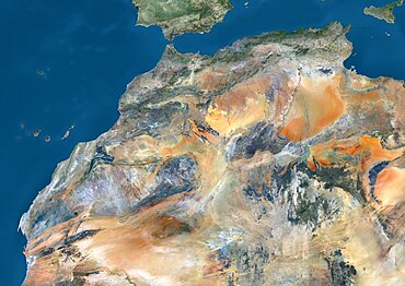
Satellite view of Algeria, Morocco and Tunisia. This image was compiled from data acquired in 2014 by Landsat 8 satellite.
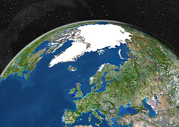
Satellite view of Europe in winter, with partial snow cover. This image was compiled from data acquired by Landsat 7 & 8 satellites.
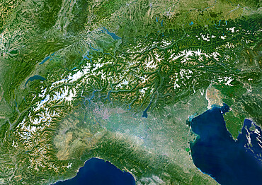
The Alps, Europe, True Colour Satellite Image. The Alps, seen from space. Mosaic of satellite images of the Alps, using LANDSAT data
Satellite view of Turks and Caicos Islands. This image was compiled from data acquired by Landsat satellites.
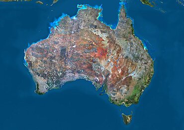
Satellite view of Australia. This image was compiled from data acquired by Landsat 8 satellite in 2014.
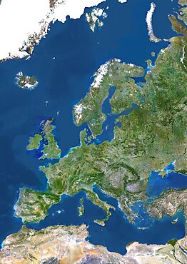
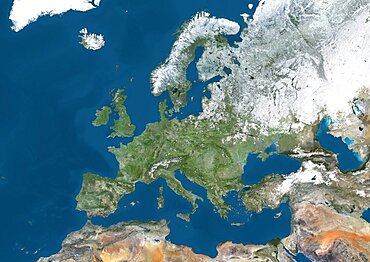
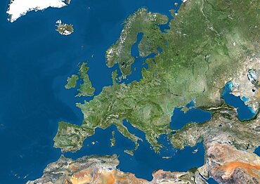
Europe, True Colour Satellite Image. True colour satellite image of Europe. This image in Lambert Conformal Conic projection was compiled from data acquired by LANDSAT 5 & 7 satellites.
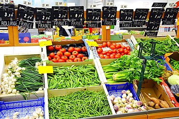
Supermarket
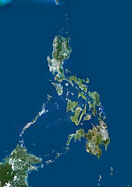
Philippines, Asia, True Colour Satellite Image. Satellite view of the Philippines. This image was compiled from data acquired by LANDSAT 5 & 7 satellites.
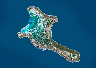
Satellite view of Christmas Island, Kiribati. This image was compiled from data acquired by Landsat 8 satellite in 2014.
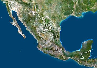
Mexico, North America, True Colour Satellite Image With Border. Satellite view of Mexico (with border). This image was compiled from data acquired by LANDSAT 5 & 7 satellites.
Reportage in the Fear of Flying treatment centre in Paris, France
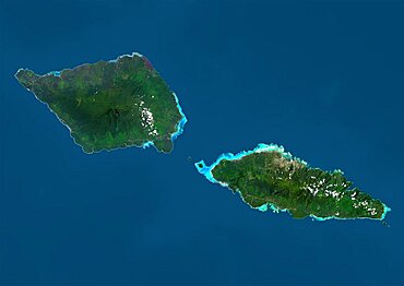
Satellite view of Samoa that consists of two large islands, Upolu and Savaii. This image was compiled from data acquired by Landsat 8 satellite in 2014.
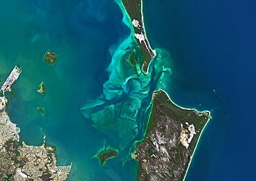
Satellite view of Moreton Bay, Queensland, Australia. This image was compiled from data acquired in 2014 by Landsat 8 satellite.
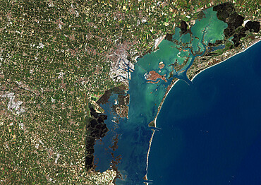
Venice, Italy, True Colour Satellite Image. Venice, France. True colour satellite image of the city of Venice that stretches across numerous small islands in the marshy Venetian Lagoon. Image taken on 26 August 2001 using LANDSAT 7 data.

Asia At Night, True Colour Satellite Image. True colour satellite image of Asia at night. This image in Lambert Azimuthal Equal Area projection was compiled from data acquired by LANDSAT 5 & 7 satellites.

Sea Of Japan, Asia, True Colour Satellite Image. True colour satellite image of the Sea of Japan, a sea of the western Pacific Ocean. It is bordered by Japan, South Korea, North Korea and Russia. Composite image using LANDSAT 5 data.
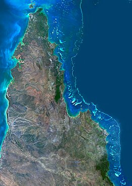
Satellite view of the Northern Great Barrier Reef along the east coast of Cape York Peninsula in north Australia. This image was compiled from data acquired in 2014 by Landsat 8 satellite.
Satellite view of Uluru Ayers Rock, Northern Territory, Australia. This image was compiled from data acquired by Landsat satellites.
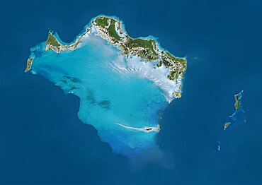
Satellite view of Grand Cayman. It is the largest of the three Cayman Islands. This image was compiled from data acquired by Landsat satellites.

Oman, Middle East, Asia, True Colour Satellite Image With Border. Satellite view of Oman (with border). This image was compiled from data acquired by LANDSAT 5 & 7 satellites.
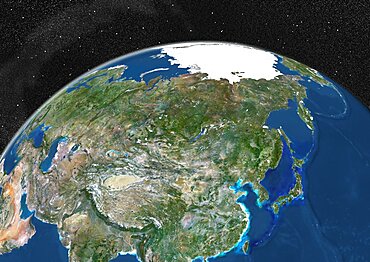
Globe Showing Asia, True Colour Satellite Image. True colour satellite image of the Earth showing Asia and the North Pole. This image in orthographic projection was compiled from data acquired by LANDSAT 5 & 7 satellites.
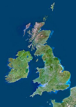
United Kingdom, Europe, True Colour Satellite Image With Border. Satellite view of Bulgaria (with border). This image was compiled from data acquired by LANDSAT 5 & 7 satellites.
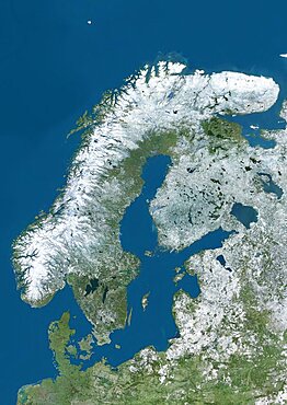
Satellite view of Northern Europe showing Scandinavia and the Baltic States in winter, with partial snow cover. This image was compiled from data acquired by Landsat 7 & 8 satellites.
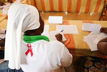
Photo essay in Lome, Togo. AIDS prevention workshop in Loyola Hope Center.
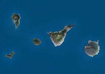
Satellite view of La Palma, Tenerife and Gran Canaria, Canary Islands, Spain. The smallest islands of La Gomera and El Hierro are also shown. This image was compiled from data acquired by Landsat 8 satellite in 2014.
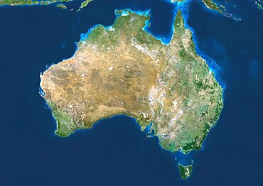
Australia, True Colour Satellite Image. Australia, true colour satellite image. This image was compiled from data acquired by LANDSAT 5 & 7 satellites.

New Orleans, Louisiana, Usa, True Colour Satellite Image. New Orleans, Louisiana, USA. True colour satellite image of the city of New Orleans, taken on 17 January 2000, using LANDSAT 7 data.
Satellite view of Europe. This image was compiled from data acquired by Landsat 7 & 8 satellites.
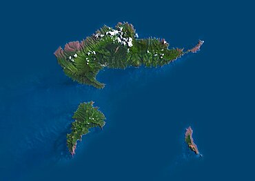
Satellite view of Hiva Oa, the second largest island in the Marquesas Islands, in French Polynesia. This image was compiled from data acquired by Landsat 8 satellite in 2014.
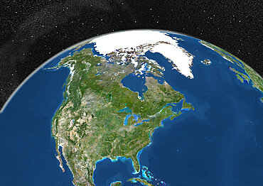
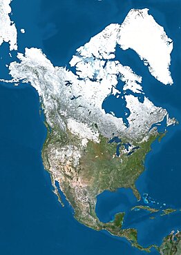
Globe Showing Northern America, True Colour Satellite Image. True colour satellite image of the Earth showing Greenland, the North Pole and Northern America. This image in orthographic projection was compiled from data acquired by LANDSAT 5 & 7 satellites.
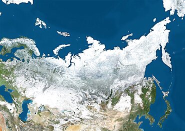
Satellite view of Russia and Central Asia in winter, with partial snow cover. This image was compiled from data acquired by Landsat 7 & 8 satellites.
Al Ayn, United Arab Emirates, True Colour Satellite Image. True colour satellite image of Al Ayn in the United Arab Emirates, located in the Emirate of Abu Dhabi. Image taken on 23 August 2000 using LANDSAT 7 data.
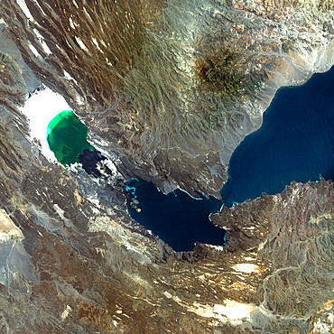
Ardoukoba Volcano, Djibouti, True Colour Satellite Image. Ardoukoba, Djibouti, true colour satellite image. Ardoukoba is a volcano located close to Assal Lake in Djibouti. Image taken on 13 May 2000 using LANDSAT data. Print size 30 x 30 cm.
Satellite view of North America in winter, with partial snow cover. This image was compiled from data acquired by Landsat 7 & 8 satellites.
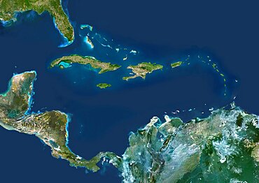
Caribbean Islands, True Colour Satellite Image. Caribbean Islands, true colour satellite image. This image was compiled from data acquired by LANDSAT 5 & 7 satellites.

Puerto Rico And The Virgin Islands, True Colour Satellite Image. Puerto Rico and the Virgin Islands. True colour satellite image showing Puerto Rico (west) and the Virgin islands (east). Composite image using data from LANDSAT 5 & 7satellites.
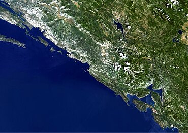
Dubrovnik, Croatia, True Colour Satellite Image. Dubrovnik, Croatia. True colour satellite image of Dubrovnik, capital city of Croatia. Image taken on 6 July 2001, using LANDSAT 7 data.
Hurricane Gordon, Atlantic Ocean, In 2006, True Colour Satellite Image. Hurricane Gordon on 14 September 2006 over the Atlantic ocean. True-colour satellite image using MODIS data.
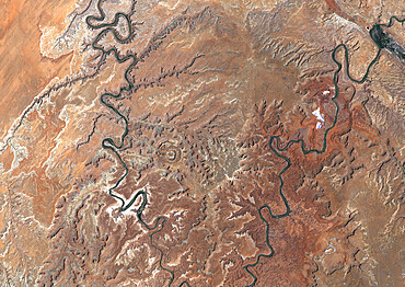
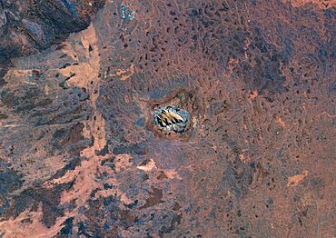
Upheaval Dome Meteor Impact Crater, Utah, Usa, True Colour Satellite Image. True colour satellite image of Upheaval Dome impact structure, Utah, US (age : 65 million years ; diameter : 5 km). Image taken on 17 June 1989 using LANDSAT data.
Globe Showing Europe, True Colour Satellite Image. True colour satellite image of the Earth showing Greenland, the North Pole and Europe. This image in orthographic projection was compiled from data acquired by LANDSAT 5 & 7 satellites.
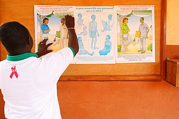
Photo essay in Lome, Togo. AIDS prevention in Loyola Hope Center.

Typhoon Mitag, Philippine Sea, Asia, In 2002, True Colour Satellite Image. Typhoon Mitag on 6 March 2002 in the Philippine Sea, north of the Philippines (lower left-hand corner of the image). True-colour satellite image using MODIS data.

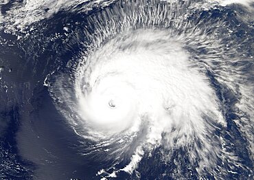
Hurricane Wilma, Atlantic Ocean, On 24/10/2005, True Colour Satellite Image. Hurricane Wilma on 24 October 2005 over Florida, US. True-colour satellite image using MODIS data.
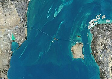
Satellite view of the King Fahd Causeway, a series of bridges and causeways connecting Saudi Arabia and Bahrain. This image was compiled from data acquired in 2014 by Landsat 8 satellite.
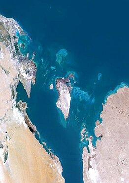
Bahrain, Middle East, Asia, True Colour Satellite Image. Satellite view of Bahrain . This image was compiled from data acquired by LANDSAT 5 & 7 satellites.

Haiti And Dominican Republic, True Colour Satellite Image. Haiti and Dominican Republic, true colour satellite image. This image was compiled from data acquired by LANDSAT 5 & 7 satellites.

Satellite view of Africa. This image was compiled from data acquired by Landsat 7 & 8 satellites.
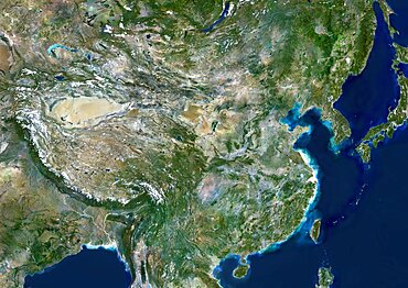
China, True Colour Satellite Image. People's Republic of China, true colour satellite image. This image was compiled from data acquired by LANDSAT 5 & 7 satellites.
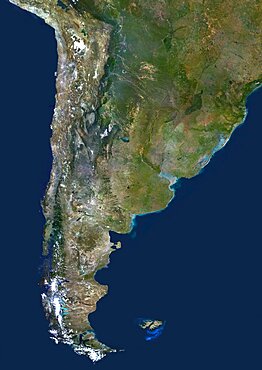
Chile And Argentina, True Colour Satellite Image. Chile & Argentina, true colour satellite image. This image was compiled from data acquired by LANDSAT 5 & 7 satellites.
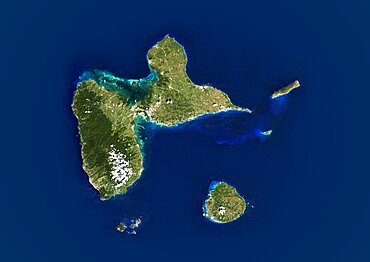
Guadeloupe, French Overseas, Caribbean, True Colour Satellite Image. Satellite view of Guadeloupe, France. This image was compiled from data acquired by LANDSAT 5 & 7 satellites.
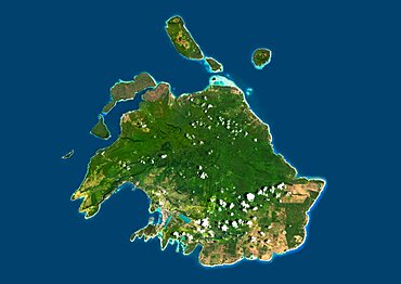
Satellite view of Efate, Vanuatu. It is the most populous island of Vanuatu archipelago. This image was compiled from data acquired by Landsat 8 satellite in 2014.
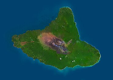
Satellite view of Ambrym, a volcanic island in the archipelago of Vanuatu. This image was compiled from data acquired by Landsat 8 satellite in 2014.
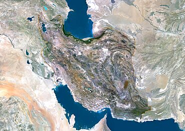
Iran, Middle East, Asia, True Colour Satellite Image With Border And Mask. Satellite view of Iran (with border and mask). This image was compiled from data acquired by LANDSAT 5 & 7 satellites.