Results
2 results found
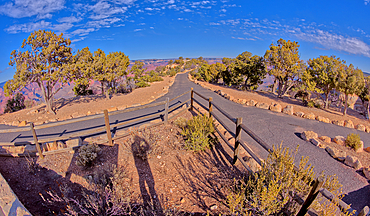
The divided paved entry pathway to the Powell Memorial from the parking lot off Hermit Road, Grand Canyon, Arizona, United States of America, North America
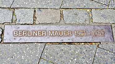
Plaque marking the site of the Berlin Wall in Potsdamerplatz, Berlin, Germany
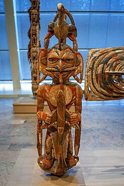
New Ireland Malagan funerary statue in at the Metropolitan Museum of Art museum, New York, USA. New Ireland is part of the Bismarck Archipelago, situated north of New Guinea, and has an estimated population of 100,000. The Dutch first encountered the island in 1616, and today New Ireland is a province of Papua New Guinea. Nineteen different languages are spoken on the island, and it is divided by a chain of mountains into three distinct regions: northern, central, and southeastern. The art of New Ireland traditionally centered on mortuary ceremonies and feasts to honor the dead. In northern New Ireland, the name given to these elaborate ceremonies is malagan, which is also the term used for the carved and painted sculptures associated with the ceremonies.
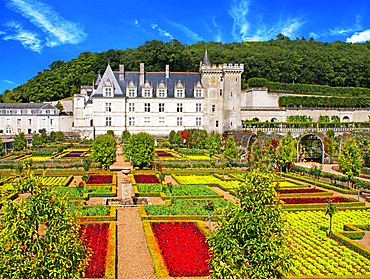
The castle and the gardens of Villandry, Loire Valley, France. The beautiful castle and gardens at Villandry, UNESCO World Heritage Site, Indre et Loire, Centre, France, Europe These gardens are divided into different areas; an ornamental next to the castle (dedicated to the tender love, passionate love, the unfaithful love and tragic love); a water garden around the pond; and a garden of medicinal herbs; aromatic; and horticulture.
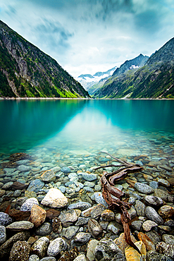
The Schlegeis reservoir in Austria
Symbol of a once divided city, Berlin, Germany
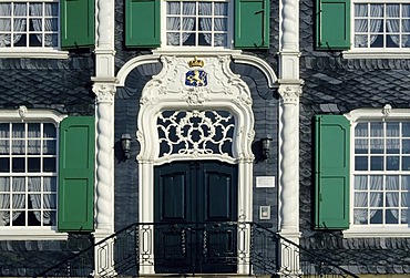
Rococo portal, local heritage museum, Remscheid-Hasten, Bergisches Land, North Rhine-Westphalia, , Germany
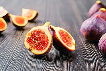
Fresh figs, whole and cut on slices on wooden table
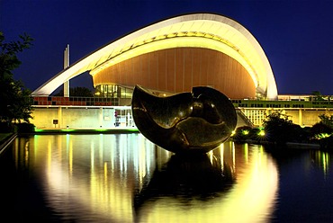
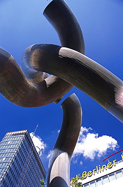
Haus der Kulturen der Welt, HKW, House of World Cultures, with bronze sculpture "Large Divided Oval: Butterfly" by Henry Moore, former Berlin Congress Hall, the "pregnant oyster", built for the Internationale Bauausstellung Interbau 1957 International Bui
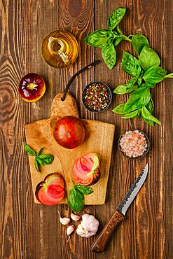
Fresh meaty tomato on wooden cutting board with basil and spice

Beautiful sporty fit woman practices yoga asana Ardha matsyendrasana, half spinal twist pose isolated on white

Halved Common fig (Ficus carica), studio shot against black background
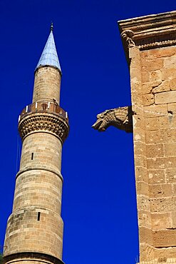
Lefkosa, Lefkosia, divided capital of Northern Cyprus, Old Town, Selimiye Mosque Tower, former St. Sophia Cathedral, Northern Cyprus
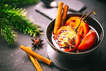
Christmas dessert - flamed tamarillo in hot wine punch with cinnamon and anise on black background

Christmas dessert - flamed tamarillo in hot wine punch with cinnamon and anise on black background

Appetizing fresh oysters with lemon on the deep dish on ice. Cheese with spices and tasty bread. Served with knives, fork, spoon and plate. White background. Copy space
Guacamole dip or spread with open sandwiches and ham on wooden kitchen table
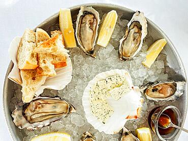
Appetizing fresh oysters with lemon on the deep dish on ice. Cheese with spices and tasty bread. Served with knives, fork, spoon and plate. White background. Copy space

Round ring shaped spritz biscuits with half side glazed with chocolate and topped with coconut sprinkles

Child holding globe studio
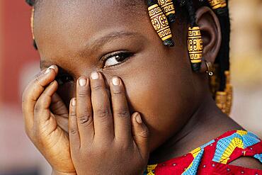
Close up african girl covering her face
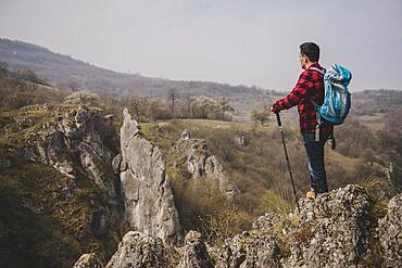
Side view rambler with backpack enjoying nature

Couple listening music earphones beach winter
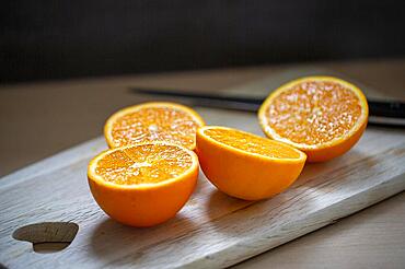
Delicious juicy oranges lie sliced on a wooden board
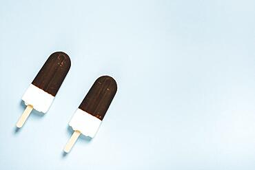
Pair ice cream half chocolate sticks

Lamps arab restaurant
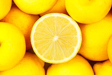
Lemons Fruits Lemon fruit from above
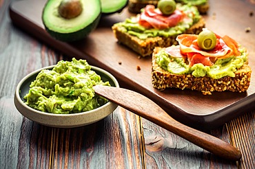
Guacamole dip or spread with open sandwiches and ham on wooden kitchen table

Black father cute son reading book couch
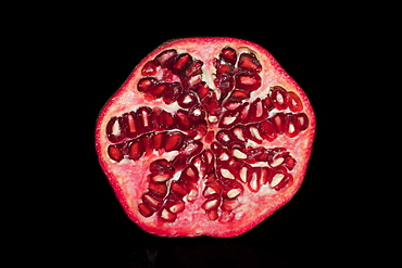
Halved pomegranate (Punica granatum), studio photography with black background
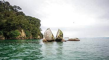
Cleaved rock, Split Apple Rock, Abel Tasman National Park, Tasman Region, Southland, New Zealand, Oceania
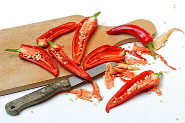
Red sliced peppers on wooden board with knife, Germany, Europe
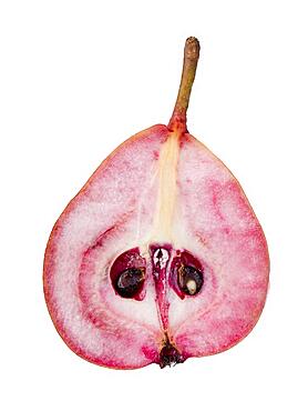
Pear variety Westphalian Blood Pear, halved, cutout
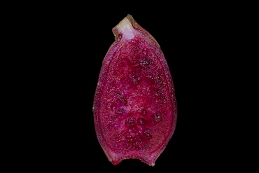
Halved ripe cactus fruit, studio photography with black background
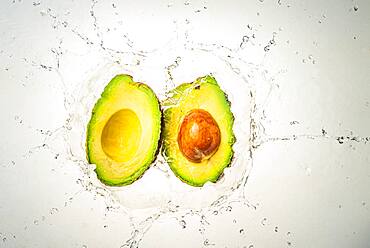
Two halves of avocado splashing into clear water, light background
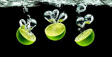
Three lime halves, splashing into water against black
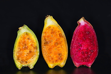
Halved cactus fruits in three different states of ripeness, studio photography with black background

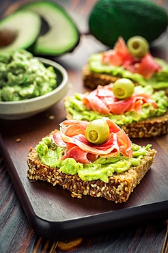
Half slice of healthy wholegrain toast bread topped with smoked salmon fish, red onions and spring onions and cucumber on horseradish
The Louisiade Archipelago is a string of ten larger volcanic islands frequently fringed by coral reefs, and 90 smaller coral islands located 200 km southeast of New Guinea, stretching over more than 160 km and spread over an ocean area of 26,000 km? between the Solomon Sea to the north and the Coral Sea to the south. The aggregate land area of the islands is about 1,790 km? (690 square miles), with Vanatinai (formerly Sudest or Tagula as named by European claimants on Western maps) being the largest.Sideia Island and Basilaki Island lie closest to New Guinea, while Misima, Vanatinai, and Rossel islands lie further east. The archipelago is divided into the Local Level Government (LLG) areas Louisiade Rural (western part, with Misima), and Yaleyamba (western part, with Rossell and Tagula islands. The LLG areas are part of Samarai-Murua District district of Milne Bay. The seat of the Louisiade Rural LLG is Bwagaoia on Misima Island, the population center of the archipelago.
The Louisiade Archipelago is a string of ten larger volcanic islands frequently fringed by coral reefs, and 90 smaller coral islands located 200 km southeast of New Guinea, stretching over more than 160 km and spread over an ocean area of 26,000 km? between the Solomon Sea to the north and the Coral Sea to the south. The aggregate land area of the islands is about 1,790 km? (690 square miles), with Vanatinai (formerly Sudest or Tagula as named by European claimants on Western maps) being the largest. Sideia Island and Basilaki Island lie closest to New Guinea, while Misima, Vanatinai, and Rossel islands lie further east. The archipelago is divided into the Local Level Government (LLG) areas Louisiade Rural (western part, with Misima), and Yaleyamba (western part, with Rossell and Tagula islands. The LLG areas are part of Samarai-Murua District district of Milne Bay. The seat of the Louisiade Rural LLG is Bwagaoia on Misima Island, the population center of the archipelago.

Nimoa Island - here the island mission will impress. The five-sided church features murals of island life and all mission buildings are surrounded by well maintained paths and gardens filled with flowering plants. Edged by jungle-covered mountains, postcard beaches and crystal clear waters - an island paradise indeed! The Louisiade Archipelago is a string of ten larger volcanic islands frequently fringed by coral reefs, and 90 smaller coral islands located 200 km southeast of New Guinea, stretching over more than 160 km and spread over an ocean area of 26,000 km? between the Solomon Sea to the north and the Coral Sea to the south. The aggregate land area of the islands is about 1,790 km? (690 square miles), with Vanatinai (formerly Sudest or Tagula as named by European claimants on Western maps) being the largest. Sideia Island and Basilaki Island lie closest to New Guinea, while Misima, Vanatinai, and Rossel islands lie further east. The archipelago is divided into the Local Level Government (LLG) areas Loui!

Nimoa Island - here the island mission will impress. The five-sided church features murals of island life and all mission buildings are surrounded by well maintained paths and gardens filled with flowering plants. Edged by jungle-covered mountains, postcard beaches and crystal clear waters - an island paradise indeed! The Louisiade Archipelago is a string of ten larger volcanic islands frequently fringed by coral reefs, and 90 smaller coral islands located 200 km southeast of New Guinea, stretching over more than 160 km and spread over an ocean area of 26,000 km? between the Solomon Sea to the north and the Coral Sea to the south. The aggregate land area of the islands is about 1,790 km? (690 square miles), with Vanatinai (formerly Sudest or Tagula as named by European claimants on Western maps) being the largest. Sideia Island and Basilaki Island lie closest to New Guinea, while Misima, Vanatinai, and Rossel islands lie further east. The archipelago is divided into the Local Level Government (LLG) areas Loui!

Nimoa Island - here the island mission will impress. The five-sided church features murals of island life and all mission buildings are surrounded by well maintained paths and gardens filled with flowering plants. Edged by jungle-covered mountains, postcard beaches and crystal clear waters - an island paradise indeed! The Louisiade Archipelago is a string of ten larger volcanic islands frequently fringed by coral reefs, and 90 smaller coral islands located 200 km southeast of New Guinea, stretching over more than 160 km and spread over an ocean area of 26,000 km? between the Solomon Sea to the north and the Coral Sea to the south. The aggregate land area of the islands is about 1,790 km? (690 square miles), with Vanatinai (formerly Sudest or Tagula as named by European claimants on Western maps) being the largest. Sideia Island and Basilaki Island lie closest to New Guinea, while Misima, Vanatinai, and Rossel islands lie further east. The archipelago is divided into the Local Level Government (LLG) areas Louisiade Rural (western part, with Misima), and Yaleyamba (western part, with Rossell and Tagula islands. The LLG areas are part of Samarai-Murua District district of Milne Bay. The seat of the Louisiade Rural LLG is Bwagaoia on Misima Island, the population center of the archipelago.
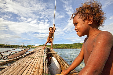
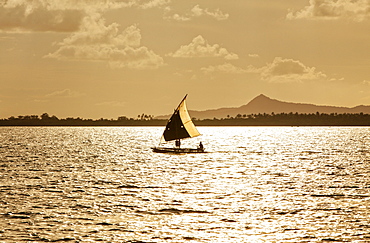
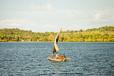
Children playing with a outrigger canoe in the village of Hessessai Bay at PanaTinai (Panatinane)island in the Louisiade Archipelago in Milne Bay Province, Papua New Guinea. The island has an area of 78 km2. The Louisiade Archipelago is a string of ten larger volcanic islands frequently fringed by coral reefs, and 90 smaller coral islands located 200 km southeast of New Guinea, stretching over more than 160 km and spread over an ocean area of 26,000 km? between the Solomon Sea to the north and the Coral Sea to the south. The aggregate land area of the islands is about 1,790 km? (690 square miles), with Vanatinai (formerly Sudest or Tagula as named by European claimants on Western maps) being the largest. Sideia Island and Basilaki Island lie closest to New Guinea, while Misima, Vanatinai, and Rossel islands lie further east. The archipelago is divided into the Local Level Government (LLG) areas Louisiade Rural (western part, with Misima), and Yaleyamba (western part, with Rossell and Tagula islands. The LLG areas are part of Samarai-Murua District district of Milne Bay. The seat of the Louisiade Rural LLG is Bwagaoia on Misima Island, the population center of the archipelago.PanaTinai (Panatinane) is an island in the Louisiade Archipelago in Milne Bay Province, Papua New Guinea.

Nimoa Island - here the island mission will impress. The five-sided church features murals of island life and all mission buildings are surrounded by well maintained paths and gardens filled with flowering plants. Edged by jungle-covered mountains, postcard beaches and crystal clear waters - an island paradise indeed! The Louisiade Archipelago is a string of ten larger volcanic islands frequently fringed by coral reefs, and 90 smaller coral islands located 200 km southeast of New Guinea, stretching over more than 160 km and spread over an ocean area of 26,000 km? between the Solomon Sea to the north and the Coral Sea to the south. The aggregate land area of the islands is about 1,790 km? (690 square miles), with Vanatinai (formerly Sudest or Tagula as named by European claimants on Western maps) being the largest. Sideia Island and Basilaki Island lie closest to New Guinea, while Misima, Vanatinai, and Rossel islands lie further east. The archipelago is divided into the Local Level Government (LLG) areas Louisiade Rural (western part, with Misima), and Yaleyamba (western part, with Rossell and Tagula islands. The LLG areas are part of Samarai-Murua District district of Milne Bay. The seat of the Louisiade Rural LLG is Bwagaoia on Misima Island, the population center of the archipelago.

Nimoa Island - here the island mission will impress. The five-sided church features murals of island life and all mission buildings are surrounded by well maintained paths and gardens filled with flowering plants. Edged by jungle-covered mountains, postcard beaches and crystal clear waters - an island paradise indeed! The Louisiade Archipelago is a string of ten larger volcanic islands frequently fringed by coral reefs, and 90 smaller coral islands located 200 km southeast of New Guinea, stretching over more than 160 km and spread over an ocean area of 26,000 km? between the Solomon Sea to the north and the Coral Sea to the south. The aggregate land area of the islands is about 1,790 km? (690 square miles), with Vanatinai (formerly Sudest or Tagula as named by European claimants on Western maps) being the largest. Sideia Island and Basilaki Island lie closest to New Guinea, while Misima, Vanatinai, and Rossel islands lie further east. The archipelago is divided into the Local Level Government (LLG) areas Louisiade Rural (western part, with Misima), and Yaleyamba (western part, with Rossell and Tagula islands. The LLG areas are part of Samarai-Murua District district of Milne Bay. The seat of the Louisiade Rural LLG is Bwagaoia on Misima Island, the population center of the archipelago.

Nimoa Island - here the island mission will impress. The five-sided church features murals of island life and all mission buildings are surrounded by well maintained paths and gardens filled with flowering plants. Edged by jungle-covered mountains, postcard beaches and crystal clear waters - an island paradise indeed! The Louisiade Archipelago is a string of ten larger volcanic islands frequently fringed by coral reefs, and 90 smaller coral islands located 200 km southeast of New Guinea, stretching over more than 160 km and spread over an ocean area of 26,000 km? between the Solomon Sea to the north and the Coral Sea to the south. The aggregate land area of the islands is about 1,790 km? (690 square miles), with Vanatinai (formerly Sudest or Tagula as named by European claimants on Western maps) being the largest. Sideia Island and Basilaki Island lie closest to New Guinea, while Misima, Vanatinai, and Rossel islands lie further east. The archipelago is divided into the Local Level Government (LLG) areas Loui!
Lush,bright green grass in farm fields along the rugged coastline of County Kerry, Ballyferriter, County Kerry, Ireland
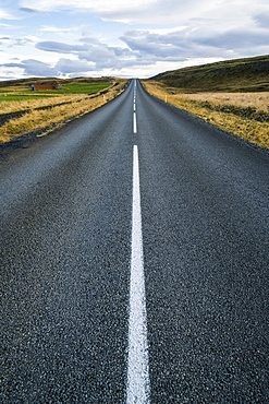
Road leading into the distance, Iceland
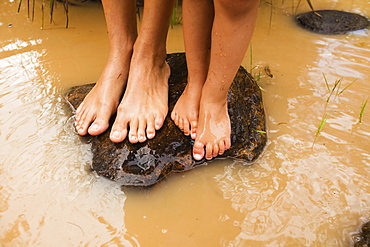
Bare Feet Standing On A Rock In Murky Water In Currumbin Creek, Currumbin, Gold Coast, Queensland, Australia
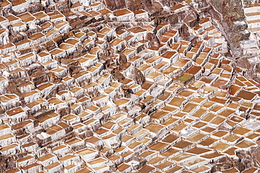
Family Owned Salt Ponds In Sacred Valley Near Urubama, Maras, Cusco, Peru
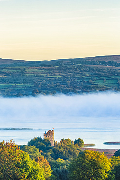
Castlebawn Tower house on the banks of Lough Derg surrounded in fog on an autumn morning; Clare, Ireland

Aerial view of farm buildings and grassy farmland separated by stone walls along the coastal mountainside; Terceira, Azores
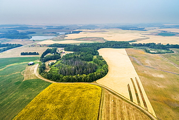
Aerial view of a patch work of different crops in a field, including sunflowers in bloom, and golden grains, with pockets of treed areas, Erickson, Manitoba, Canada

Old stone cross gravestone in graveyard with patchwork of fields in the background; Cornwall County, England
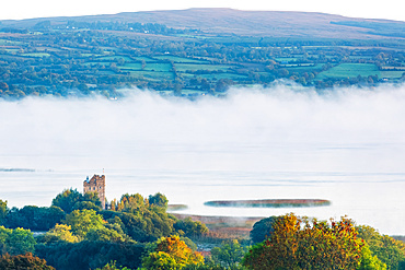
Castlebawn Tower house on the banks of Lough Derg surrounded in fog on an autumn morning; Clare, Ireland
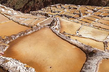
Family Owned Salt Ponds In Sacred Valley Near Urubama, Maras, Cusco, Peru
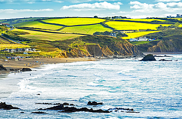
A patchwork of hilly fields bordered by trees and shrubs along the cliffs with blue sky and clouds; Cornwall County, England

Aerial image of the agricultural land on the island of Oahu, Oahu, Hawaii, United States of America
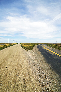
Fork In The Road, Saskatchewan, Canada
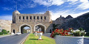
OMAN Muscat Muscat Gate Museum Crenellated gatehouse with archways over roads divided by central strip of grass with white tubs of red and white flowers.
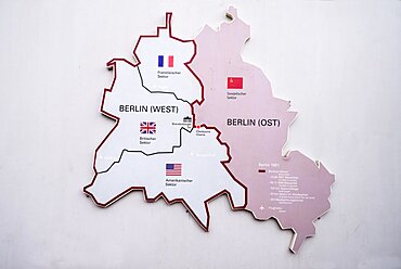
Germany, Berlin, Checkpoint Charlie, Open air exhibition showing map of divided Berlin.
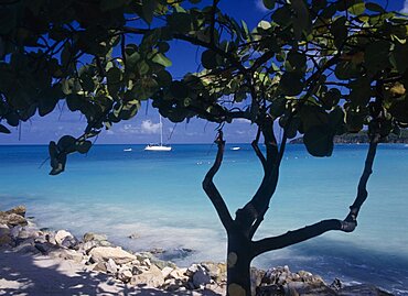
WEST INDIES Antigua Dickenson Bay View across clear aquamarine water towards distant yachts divided and partly framed by tree in shadow in the foreground.
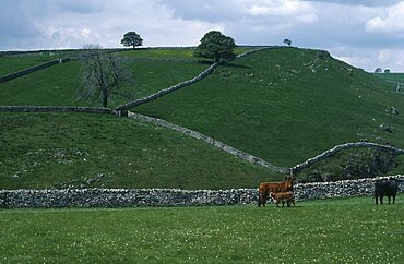
Dovedale, Pastureland divided by dry stone walls with cattle and calf in foreground, Peak District, Derbyshire, England, United Kingdom
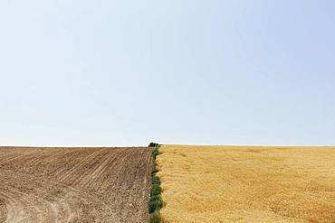
Summer wheat field divided by weeds and harvest half, Whitman County, Palouse, Washington