Results
3 results found
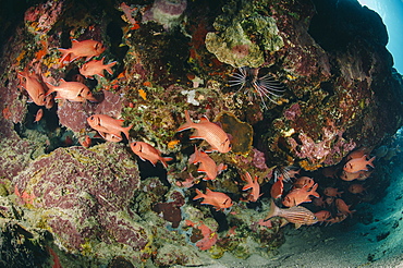
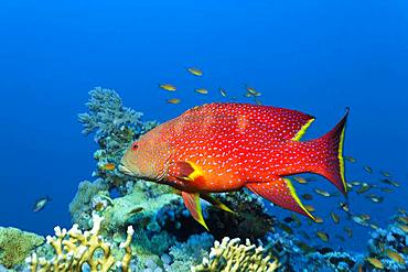
Small school of Blotcheye soldierfish (White edged soldier fish) (Myripristis murdjan), Naama Bay, Sharm El Sheikh, Red Sea, Egypt, North Africa, Africa
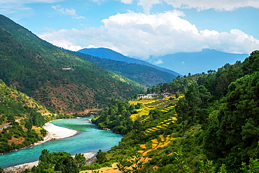
Punakha landscape edged by Pho Chhu River and the Himalayas, Punakha, Bhutan, Asia

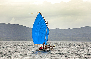
A tiny sail ship on the mountain edged Lake Wakatipu near Queenstown, Otago, South Island, New Zealand, Pacific
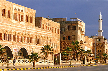
Syria, Mediterranean Coast, Tartus, Seafront Avenue Edged By Palms, Remnants Of Walls Of Fortress Built By The French Crusaders Can Be Seen On The Ground Floor Of Later Buildings
Yellow-edged lyretail grouper (Variola louti) transitional phase, Rongelap, Marshall Islands, Micronesia, Pacific
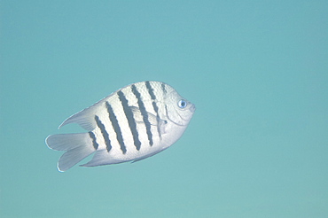
bengal sergeant (abudefduf bengalensis) wild, day, marine protected area, diving off Coral Bay, Ningaloo reef, Western Australia, Indian Ocean. MORE INFO: has rounded, white-edged tail lobes.
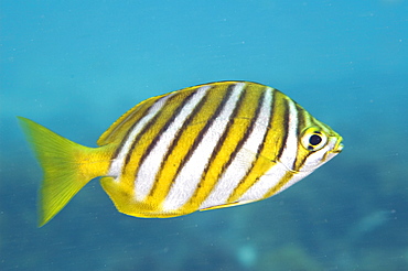
footballer sweep (neatypus obliquus) diagonal yellow bands are edged in black and stand out against the silvery-blue body, wild, day, marine protected area, reef, in small schools diving off Rottnest Island, Western Australia, Indian Ocean. MORE INFO: other name stripey, eating green algae as they sweep over the reef.
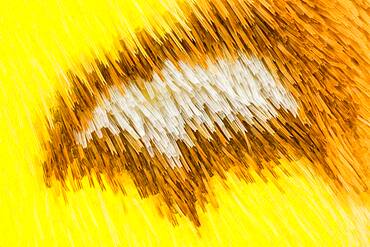
This species is unmistakable within its range, with bright yellow wings marked with small brown patches along the costa of the forewing and a small brown-edged white stigma, also on the forewing.
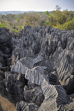
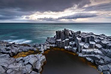
sharp-edged karst landscape, Tsingy de Bemaraha National Park, Madagascar, Mahajanga Province, Africa, UNESCO World Heritage Site
Svartifoss waterfall in the Skaftafell National Park Iceland during a summer day
View from Cape Dyrholaey, rock formations Reynisdrangar and Mount Reynisfjall, Vik i Myrdal, Suourland, Iceland, Europe
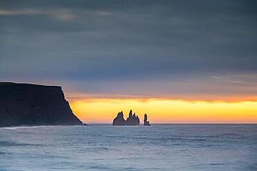
View from Cape Dyrholaey at sunrise, rock formations Reynisdrangar and Mount Reynisfjall, Vik i Myrdal, Suourland, Iceland, Europe

View from Cape Dyrholaey at sunrise, rock formations Reynisdrangar and Mount Reynisfjall, Vik i Myrdal, Suourland, Iceland, Europe
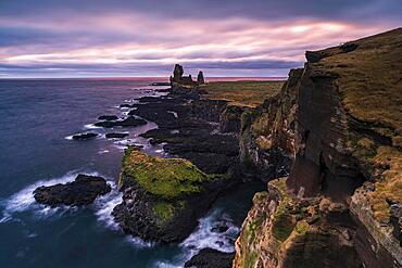
Basalt rock Londrangar, cliff, Hellnar, Snaefellsnes Peninsula, West Iceland, Iceland, Europe
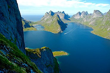
Big rock of Navaren and rough mountains with fjord Kjerkfjorden Moskenesoya Lofoten Norway
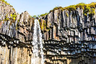
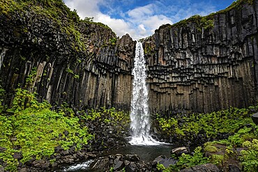
Svartifoss, Skaftafell National Park, Sudurland, South Iceland, Iceland, Europe

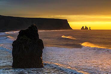
Reynisdrangar, stormy sea at sunrise, near Reynisfjara, Sudurland, South Iceland, Iceland, Europe
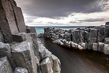
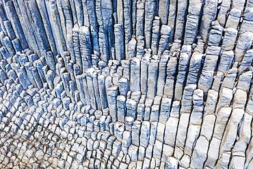
Coastal basalt cliffs, basalt columns, Blackhead, Dunedin, Otago, South Island, New Zealand, Oceania
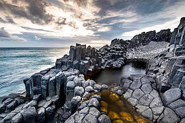
Coastal basalt cliffs, basalt columns, Blackhead, Dunedin, Otago, South Island, New Zealand, Oceania

Basalt rock formation Los Organos, Organ Pipe Rock, near Vallehermoso, aerial view, La Gomera, Canary Islands, Spain, Europe

Svartifoss, Skaftafell National Park, Sudurland, South Iceland, Iceland, Europe
Coastal basalt cliffs, basalt columns, Blackhead, Dunedin, Otago, South Island, New Zealand, Oceania

Reynisdrangar, stormy sea in the morning light near Reynisfjara, Sudurland, Southern Iceland, Iceland, Europe
Basalt rock formation Los Organos, Organ Pipe Rock, near Vallehermoso, aerial view, La Gomera, Canary Islands, Spain, Europe
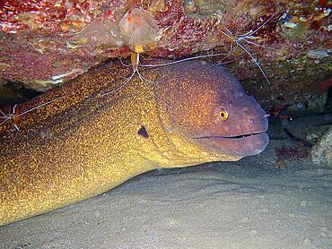
Yellow-edged moray (Gymnothorax flavimarginatus) at cleaning station with pacific cleaner shrimp (Lysmata amboinensis), Sodwana Bay National Park dive site, Maputaland Marine Reserve, KwaZulu Natal, South Africa, Africa
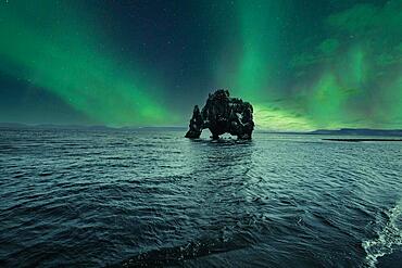
Hvitserkur landscape at night with beautiful Northern Lights. Iceland
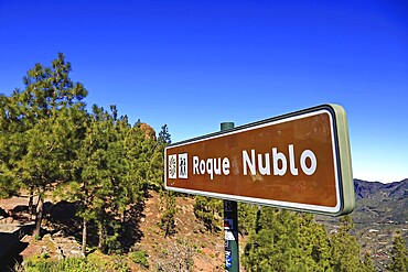
Roque Nublo
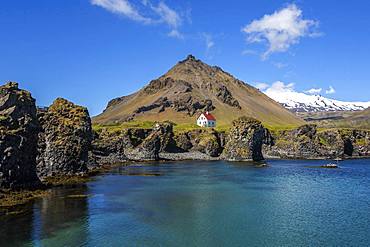
Lonely house on the basalt coast near the harbour, behind the mountain Stapafell and the glacier Snaefelljoekull, Arnarstapi, peninsula Snaefellsness, Iceland, Europe
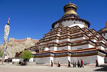
Tibetan pilgrims at kora around Kumbum Pelkor Chode Monastery Gyantse Tibet China

Reynisdrangar, stormy sea at sunrise, near Reynisfjara, Sudurland, South Iceland, Iceland, Europe
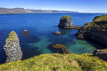
Steep coast, basalt coast near Arnarstapi, behind the mountains of the peninsula Snaefellsness, Iceland, Europe
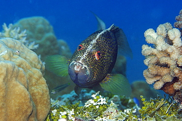
Yellow-edged lyretail (Variola louti) floats over coral reef, Red Sea, Egypt, Africa

Nimoa Island - here the island mission will impress. The five-sided church features murals of island life and all mission buildings are surrounded by well maintained paths and gardens filled with flowering plants. Edged by jungle-covered mountains, postcard beaches and crystal clear waters - an island paradise indeed! The Louisiade Archipelago is a string of ten larger volcanic islands frequently fringed by coral reefs, and 90 smaller coral islands located 200 km southeast of New Guinea, stretching over more than 160 km and spread over an ocean area of 26,000 km? between the Solomon Sea to the north and the Coral Sea to the south. The aggregate land area of the islands is about 1,790 km? (690 square miles), with Vanatinai (formerly Sudest or Tagula as named by European claimants on Western maps) being the largest. Sideia Island and Basilaki Island lie closest to New Guinea, while Misima, Vanatinai, and Rossel islands lie further east. The archipelago is divided into the Local Level Government (LLG) areas Loui!

Nimoa Island - here the island mission will impress. The five-sided church features murals of island life and all mission buildings are surrounded by well maintained paths and gardens filled with flowering plants. Edged by jungle-covered mountains, postcard beaches and crystal clear waters - an island paradise indeed! The Louisiade Archipelago is a string of ten larger volcanic islands frequently fringed by coral reefs, and 90 smaller coral islands located 200 km southeast of New Guinea, stretching over more than 160 km and spread over an ocean area of 26,000 km? between the Solomon Sea to the north and the Coral Sea to the south. The aggregate land area of the islands is about 1,790 km? (690 square miles), with Vanatinai (formerly Sudest or Tagula as named by European claimants on Western maps) being the largest. Sideia Island and Basilaki Island lie closest to New Guinea, while Misima, Vanatinai, and Rossel islands lie further east. The archipelago is divided into the Local Level Government (LLG) areas Loui!

Nimoa Island - here the island mission will impress. The five-sided church features murals of island life and all mission buildings are surrounded by well maintained paths and gardens filled with flowering plants. Edged by jungle-covered mountains, postcard beaches and crystal clear waters - an island paradise indeed! The Louisiade Archipelago is a string of ten larger volcanic islands frequently fringed by coral reefs, and 90 smaller coral islands located 200 km southeast of New Guinea, stretching over more than 160 km and spread over an ocean area of 26,000 km? between the Solomon Sea to the north and the Coral Sea to the south. The aggregate land area of the islands is about 1,790 km? (690 square miles), with Vanatinai (formerly Sudest or Tagula as named by European claimants on Western maps) being the largest. Sideia Island and Basilaki Island lie closest to New Guinea, while Misima, Vanatinai, and Rossel islands lie further east. The archipelago is divided into the Local Level Government (LLG) areas Louisiade Rural (western part, with Misima), and Yaleyamba (western part, with Rossell and Tagula islands. The LLG areas are part of Samarai-Murua District district of Milne Bay. The seat of the Louisiade Rural LLG is Bwagaoia on Misima Island, the population center of the archipelago.
Nimoa Island - here the island mission will impress. The five-sided church features murals of island life and all mission buildings are surrounded by well maintained paths and gardens filled with flowering plants. Edged by jungle-covered mountains, postcard beaches and crystal clear waters - an island paradise indeed! The Louisiade Archipelago is a string of ten larger volcanic islands frequently fringed by coral reefs, and 90 smaller coral islands located 200 km southeast of New Guinea, stretching over more than 160 km and spread over an ocean area of 26,000 km? between the Solomon Sea to the north and the Coral Sea to the south. The aggregate land area of the islands is about 1,790 km? (690 square miles), with Vanatinai (formerly Sudest or Tagula as named by European claimants on Western maps) being the largest. Sideia Island and Basilaki Island lie closest to New Guinea, while Misima, Vanatinai, and Rossel islands lie further east.

Nimoa Island - here the island mission will impress. The five-sided church features murals of island life and all mission buildings are surrounded by well maintained paths and gardens filled with flowering plants. Edged by jungle-covered mountains, postcard beaches and crystal clear waters - an island paradise indeed! The Louisiade Archipelago is a string of ten larger volcanic islands frequently fringed by coral reefs, and 90 smaller coral islands located 200 km southeast of New Guinea, stretching over more than 160 km and spread over an ocean area of 26,000 km? between the Solomon Sea to the north and the Coral Sea to the south. The aggregate land area of the islands is about 1,790 km? (690 square miles), with Vanatinai (formerly Sudest or Tagula as named by European claimants on Western maps) being the largest. Sideia Island and Basilaki Island lie closest to New Guinea, while Misima, Vanatinai, and Rossel islands lie further east. The archipelago is divided into the Local Level Government (LLG) areas Louisiade Rural (western part, with Misima), and Yaleyamba (western part, with Rossell and Tagula islands. The LLG areas are part of Samarai-Murua District district of Milne Bay. The seat of the Louisiade Rural LLG is Bwagaoia on Misima Island, the population center of the archipelago.

Nimoa Island - here the island mission will impress. The five-sided church features murals of island life and all mission buildings are surrounded by well maintained paths and gardens filled with flowering plants. Edged by jungle-covered mountains, postcard beaches and crystal clear waters - an island paradise indeed! The Louisiade Archipelago is a string of ten larger volcanic islands frequently fringed by coral reefs, and 90 smaller coral islands located 200 km southeast of New Guinea, stretching over more than 160 km and spread over an ocean area of 26,000 km? between the Solomon Sea to the north and the Coral Sea to the south. The aggregate land area of the islands is about 1,790 km? (690 square miles), with Vanatinai (formerly Sudest or Tagula as named by European claimants on Western maps) being the largest. Sideia Island and Basilaki Island lie closest to New Guinea, while Misima, Vanatinai, and Rossel islands lie further east. The archipelago is divided into the Local Level Government (LLG) areas Louisiade Rural (western part, with Misima), and Yaleyamba (western part, with Rossell and Tagula islands. The LLG areas are part of Samarai-Murua District district of Milne Bay. The seat of the Louisiade Rural LLG is Bwagaoia on Misima Island, the population center of the archipelago.

Nimoa Island - here the island mission will impress. The five-sided church features murals of island life and all mission buildings are surrounded by well maintained paths and gardens filled with flowering plants. Edged by jungle-covered mountains, postcard beaches and crystal clear waters - an island paradise indeed! The Louisiade Archipelago is a string of ten larger volcanic islands frequently fringed by coral reefs, and 90 smaller coral islands located 200 km southeast of New Guinea, stretching over more than 160 km and spread over an ocean area of 26,000 km? between the Solomon Sea to the north and the Coral Sea to the south. The aggregate land area of the islands is about 1,790 km? (690 square miles), with Vanatinai (formerly Sudest or Tagula as named by European claimants on Western maps) being the largest. Sideia Island and Basilaki Island lie closest to New Guinea, while Misima, Vanatinai, and Rossel islands lie further east. The archipelago is divided into the Local Level Government (LLG) areas Loui!
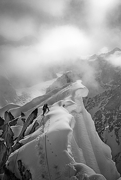
CJ Pearson navigates the knife-edged and corniced ridge of Peak 11,300 in the Alaska Range, United States of America
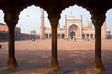
Jama Masjid Mosque Delhi, the courtyard at a mosque, with a colonnade with scalloped edged arches.
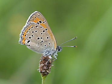
Purple-edged Copper on Plantago, Franche-Comté France

Purple-edged Copper on Groundsel, Franche-Comté France