Results
2 results found
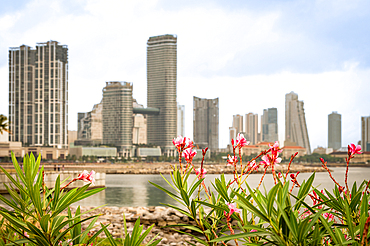
Port City, Colombo, Sri Lanka
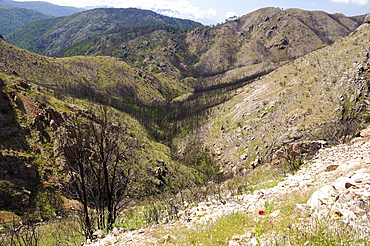
Aftermath of a major forest fire within Corsica's National Park (Parc Naturel Regional de Corse), a year on, with large area of forest and maquis scrub destroyed and first flush of regrowth by grasses and flowers, near Aullene, Corsica, France.

Flowering Crabapple tree blossoms at the Yakima Area Arboretum in Yakima, Washington.
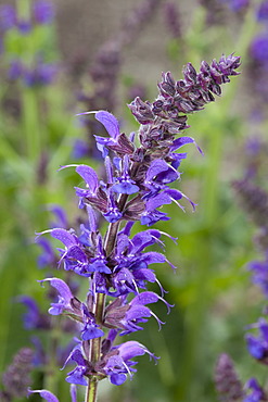
Woodland sage (Salvia nemorosa "May Night"), Maximilianpark, Maxipark, Hamm, Ruhr Area, North Rhine-Westphalia, Germany, Europe
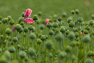
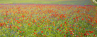
Poppy field, Armschlag, Waldviertel, Forest Quarter, Lower Austria, Austria, Europe
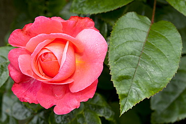
Climbing Rose, Rosanna (Rosa), Westphalia Park, Dortmund, Ruhr Area, North Rhine-Westphalia, Germany, Europe
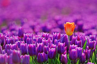
Tulips (Tulipa sp.), Lisse, South Holland, Holland, Netherlands, Europe

Field of tulips (Tulipa), Texel, The Netherlands, Europe

Hybrid Tea Rose, Orient Express (Rosa), Westphalia Park, Dortmund, Ruhr Area, North Rhine-Westphalia, Germany, Europe

Poppy field, Armschlag, Waldviertel, Forest Quarter, Lower Austria, Austria, Europe

Blossom, epicactus (Epiphyllum Pegasus), Botanical Garden, Bochum, Ruhr area, North Rhine-Westphalia, Germany, Europe
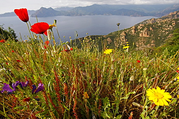
Wild flowers and poppies at the Gulf of Porto, Corsica Island, France, Europe
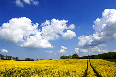
Field of rape (Brassica napus) in bloom, Krembz, Mecklenburg-Western Pomerania, Germany, Europe

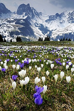
Meadow filled with crocuses (Crocus), foehn, lenticular clouds near Gerold, Wetterstein Range, Upper Bavaria, Bavaria, Germany
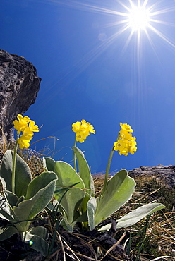
Bear's Ear Primroses (Primula auricula L.), Kalk Alps National Park, Upper Austria, Austria, Europe
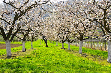
Apricot trees (Prunus armeniaca) in bloom, Wachau, Austria's biggest apricot growing area, Lower Austria, Austria, Europe
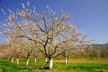
Apricot trees (Prunus armeniaca) in bloom, Wachau, Austria's biggest apricot growing area, Lower Austria, Austria, Europe
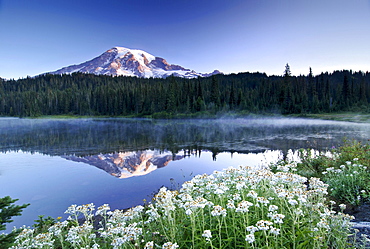
Mt Rainier reflected in a lake, flower meadow at front, Mount Rainier National Park, Washington, USA, North America
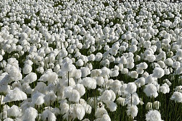
Field of Cottongrass (Eriophorum), Torngat Mountains National Park, Newfoundland and Labrador, Canada, Arctic
Myrtos, Crete, Greece, Europe

Blooming Azaleas shrub, Rombergpark botanical garden, Dortmund, Ruhrgebiet region, North Rhine-Westphalia, Germany, Europe
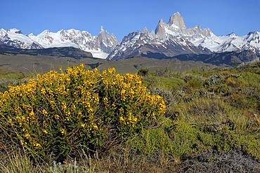
Mt. Cerro Torre and Mt. Fitz Roy, El Chalten, Andes, Patagonia, Argentina, South America
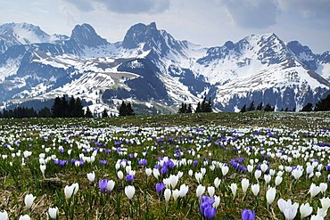
A field of blooming crocuses (Crocus vernus) near the Gurnigel Pass, the snowy Alps at the back, Bern, Switzerland, Europe

Killary Harbour with rhododendron shrubs, Connemara, County Galway, Republic of Ireland, Europe

Rhododendron shrubs on the Killary Harbour, Connemara, County Galway, Republic of Ireland, Europe
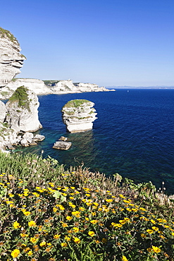
Free-standing rock Grain de Sable on the rocky coast near Bonifacio, Strait of Bonifacio, Corsica, France, Europe
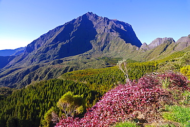
View of Mt. Piton de Neige in the Salazie volcano crater, blooming heather at front, La Reunion island, Indian Ocean
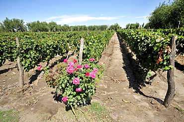
Winegrowing, Malbec grape variety, roses are used as indicators for an infestation of the vines by insects, Maipu, Mendoza Province, Argentina, South America

Dandelions in front of Latemargebirge, Latemar mountain range, Deutschnofen area, South Tyrol, Italy, Europe

Boardwalk in the Naturschutzgebiet Dosenmoor nature reserve, regenerating and partially preserved bog, Kreis Neumuenster county, Schleswig-Holstein, Germany, Europe

Boardwalk in the Naturschutzgebiet Dosenmoor nature reserve, regenerating and partially preserved bog, Kreis Neumuenster county, Schleswig-Holstein, Germany, Europe
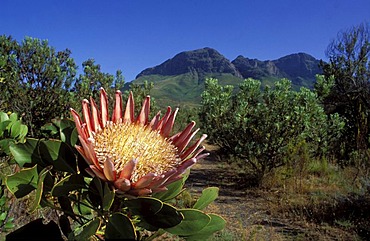
King Protea (Protea cynaroides), in endangered fynbos habitat, Helderberg Nature Reserve, near Cape Town, Western Cape, South Africa, Africa
Svartisen glacier, Holandsfjord, Norway, Scandinavia, Europe
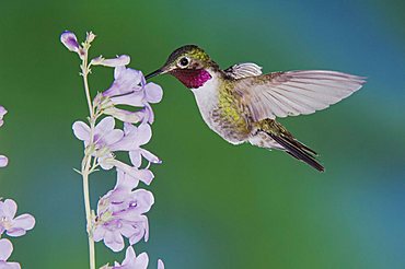
Broad-tailed Hummingbird (Selasphorus platycercus), male in flight feeding on Rocky Mountain Penstemon (Penstemon strictus), Rocky Mountain National Park, Colorado, USA
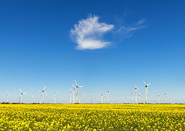
Wind turbines in rape fields in front of blue sky, Norderwoehrden, Schleswig-Holstein, Germany, Europe
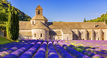
The Romanesque Cistercian Abbey of Notre Dame of Senanque set amongst flowering lavender fields, near Gordes, Provence, France, Europe

Flowering strip, flowering area with poppy flowers (Papaver rhoeas) and cornflowers (Centaurea cyanus), North Rhine-Westphalia, Germany, Europe

Cultivated Almond trees (Prunus dulcis) in full blossom, Almeria province, Andalusia, Spain, Europe

Field of Tulips (Tulipa sp.), near Lisse, South Holland, Holland, Netherlands, Europe
Blooming crocuses (Crocus vernus) near the Gurnigel Pass, the snowy Alps at the back, Bern, Switzerland, Europe
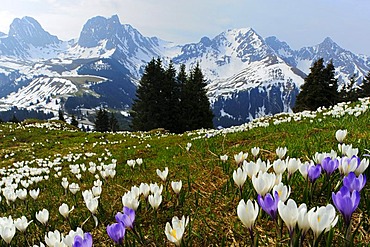
Blooming crocuses (Crocus vernus) near the Gurnigel Pass, the snowy Alps at the back, Bern, Switzerland, Europe

Medieval town of Gmuend/Carinthia, Liesertal Valley, Carinthia, Austria, Europe
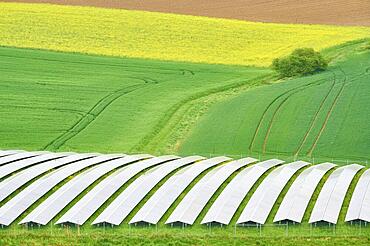
Landscape, solar area, fields, rape field, blossom, spring, Miltenberg, Spessart, Bavaria, Germany, Europe

Flowering meadow viewed by tourists, Piano Grande or Great Plain, Monti Sibillini National Park near the village of Castelluccio, Umbria, Italy, Europe
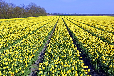
Field of Tulips (Tulipa spec.) near Lisse, Netherlands, Europe

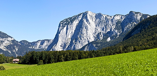
Malerwinkel, painter's viewpoint, Ramsau Church, Reiteralpen Alps near Berchtesgaden, Upper Bavaria, Germany, Europe

Primula (Primula clusiana), Kalkalpen National Park, Upper Austria, Austria, Europe
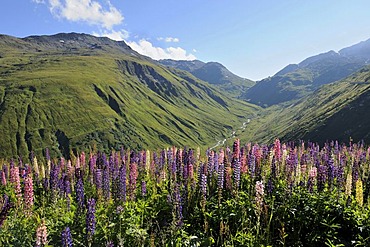
View from the summit of the Furka Pass in the direction of Urnerland, with wild Large-leaved Lupines, Big-leaved Lupines (Lupinus polyphyllus), Uri, Switzerland, Europe
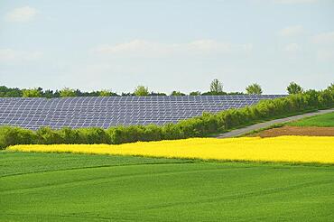
Landscape, solar area, fields, rape field, blossom, spring, Miltenberg, Spessart, Bavaria, Germany, Europe
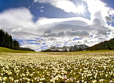
Meadow filled with crocuses (Crocus), foehn, lenticular clouds near Gerold, Wetterstein Range, Upper Bavaria, Bavaria, Germany
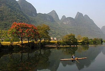
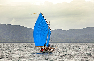
Chinese fisherman with a straw hat on a bamboo raft fishing near Yangshuo in Yulong River in front of flowering trees and karst rocks, Yangshuo, Guilin, Guanxi, China, Asia
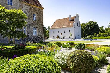
Flower garden in the Obernberg castle area, Obernberg am Inn, Innviertel, Upper Austria, Austria, Europe
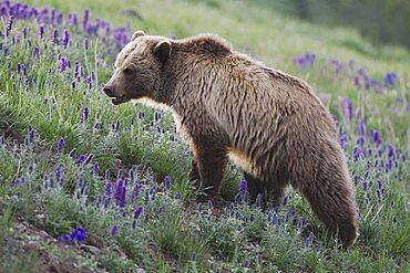
Grizzly Bear (Ursus arctos horribilis), adult in blooming Purple Fringe (Phacelia sericea) flowers, Yellowstone National Park, Wyoming, USA
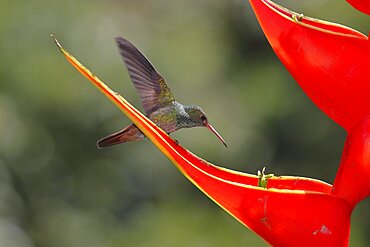
Rufous-tailed hummingbird (Amazilia tzacatl) on scarlet lobster-claw (Heliconia bihai), Sarapiqui area, Costa Rica, Central America
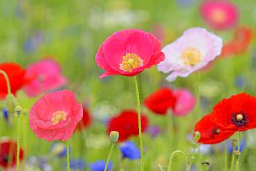
Flowering strip, flowering area with poppy flowers (Papaver rhoeas) and cornflowers (Centaurea cyanus), North Rhine-Westphalia, Germany, Europe

Tulips (Tulipa spec.)

Blooming crocuses (Crocus vernus) near the Gurnigel Pass, the snowy Alps at the back, Bern, Switzerland, Europe

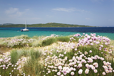
Flowers, bay on Cukurbag peninsula, Kas, Lycian coast, Antalya Province, Mediterranean, Turkey, Eurasia
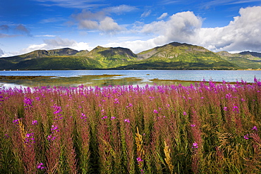
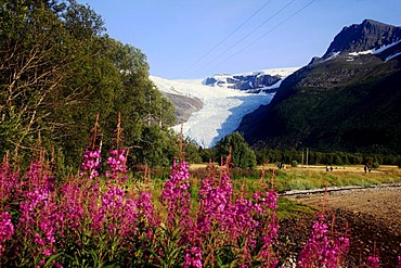
Willow herb, Risoysundet, island of Hinnoya Iinnasuolu, Vesteralen, Norway, Scandinavia, Europe

TV Tower, so-called Florian, roses in bloom, rose garden, Westfalenpark, Dortmund, Ruhrgebiet region, North Rhine-Westphalia, Germany, Europe

Snake River, Schwabacher Landing, in front of the Teton Range, Grand Teton National Park, Wyoming, United States of America, USA

Pond with water lily (Nymphaea), reflection, Westfalenpark, Dortmund, Ruhrgebiet region, North Rhine-Westphalia, Germany, Europe

City panorama seen from Philosophers' Walk, Heidelberg, Neckar, Palatinate, Baden-Wuerttemberg, Germany, Europe
Flowering cloves on the beach of Porto Puddu, Sardinia, Italy, Europe

Cityscape with Old Bridge or Karl-Theodor Bridge, Heidelberg, Neckar, Palatinate, Baden-Wuerttemberg, Germany, Europe

Vineyards and poppy field, Ardeche, Rhone-Alpes, France, Europe

Pond with water lily (Nymphaea), Westfalenpark, Dortmund, Ruhrgebiet region, North Rhine-Westphalia, Germany, Europe

Pink roses, climbing roses, rose garden, Westfalenpark, Dortmund, Ruhrgebiet region, North Rhine-Westphalia, Germany, Europe

Hiking trail around Schliffkopf mountain in the Black Forest, Baden-Wuerttemberg, Germany, Europe
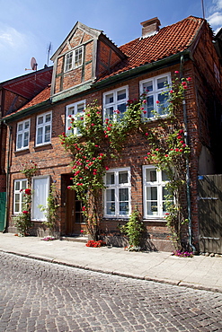
Historic old town, Eutin, Naturpark Holsteinische Schweiz, nature park, Schleswig-Holstein, Germany, Europe

Pilgrimage Church of St. Coloman near Fuessen, Thannheim Mountains, spring, East Allgaeu, Allgaeu, Bavaria, Germany, Europe
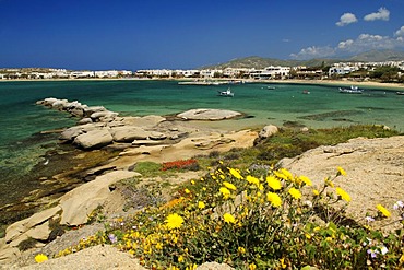
Aghia Anna beach, Naxos, Cyclades, Greece, Europe

Rocky coastline with a view to Bonifacio, Strait of Bonifacio, Corsica, France, Europe

Sunflowers (Helianthus annuus)
Chapel at Lake Hegratsrieder near Buching, East Allgaeu, Allgaeu, Bavaria, Germany, Europe

Flowering tulips, spring in Westfalenpark, Dortmund, Ruhr Area, North Rhine-Westphalia, Germany, Europe
The Altes Land fruit growing area during the cherry blossom, Lower Elbe, Lower Saxony, North Germany, Germany, Europe
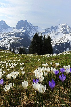
Blooming crocuses (Crocus vernus) near the Gurnigel Pass, the snowy Alps at the back, Bern, Switzerland, Europe

Elbe river landscape in Kirchwerder, Vier- und Marschlande area, Hamburg, Germany, Europe

The village of Perce on the gulf of the St. Lawrence River, Gaspe peninsula, Gaspesie, Quebec, Canada

Roses in bloom, rose garden, Westfalenpark, Dortmund, Ruhrgebiet region, North Rhine-Westphalia, Germany, Europe

Cliffs of Moher, County Clare, Ireland, Europe

View over valley and blooms, Ciudad Velha, Cidade Velha, island of Santiago, Cabo Verde, Africa

Dry grasslands, Moenchgut, Moenchgut Nature Reserve, Southeast Ruegen Biosphere Reserve, Ruegen, Mecklenburg-Western Pomerania, Germany, Europe

TV Tower, so-called Florian, roses in bloom, rose garden, Westfalenpark, Dortmund, Ruhrgebiet region, North Rhine-Westphalia, Germany, Europe
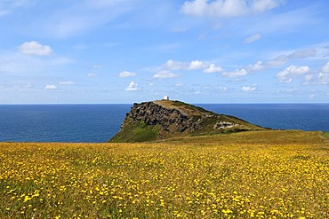
Rugged cliffs on the coast near Boscastle, National Coastwatch observation tower at the back, flowering meadow at the front, Boscastle, Cornwall, England, United Kingdom, Europe

Fence lined with flowers along the hiking trail around Schliffkopf mountain, Black Forest, Baden-Wuerttemberg, Germany, Europe

Weinschloessl castle, Kellerschloessel castle, Duernstein, Wachau valley, Waldviertel region, Lower Austria, Austria, Europe
Green flowering alpine pasture in front of rugged mountains, Tressensattel gap, Altaussee, Salzkammergut, Austria, Europe

Houses in the town of Gargallo in the afternoon sun, Teruel Province, Spain, Europe

View towards Oberstdorf and the Allgaeu Alps, Allgaeu, Bavaria, Germany, Europe
Monti Sibillini National Park, Flowering Pian Grande, July, Castelluccio di Norcia, Umbria, Italy, Europe

Nimoa Island - here the island mission will impress. The five-sided church features murals of island life and all mission buildings are surrounded by well maintained paths and gardens filled with flowering plants. Edged by jungle-covered mountains, postcard beaches and crystal clear waters - an island paradise indeed! The Louisiade Archipelago is a string of ten larger volcanic islands frequently fringed by coral reefs, and 90 smaller coral islands located 200 km southeast of New Guinea, stretching over more than 160 km and spread over an ocean area of 26,000 km? between the Solomon Sea to the north and the Coral Sea to the south. The aggregate land area of the islands is about 1,790 km? (690 square miles), with Vanatinai (formerly Sudest or Tagula as named by European claimants on Western maps) being the largest. Sideia Island and Basilaki Island lie closest to New Guinea, while Misima, Vanatinai, and Rossel islands lie further east. The archipelago is divided into the Local Level Government (LLG) areas Loui!

Nimoa Island - here the island mission will impress. The five-sided church features murals of island life and all mission buildings are surrounded by well maintained paths and gardens filled with flowering plants. Edged by jungle-covered mountains, postcard beaches and crystal clear waters - an island paradise indeed! The Louisiade Archipelago is a string of ten larger volcanic islands frequently fringed by coral reefs, and 90 smaller coral islands located 200 km southeast of New Guinea, stretching over more than 160 km and spread over an ocean area of 26,000 km? between the Solomon Sea to the north and the Coral Sea to the south. The aggregate land area of the islands is about 1,790 km? (690 square miles), with Vanatinai (formerly Sudest or Tagula as named by European claimants on Western maps) being the largest. Sideia Island and Basilaki Island lie closest to New Guinea, while Misima, Vanatinai, and Rossel islands lie further east. The archipelago is divided into the Local Level Government (LLG) areas Loui!

Nimoa Island - here the island mission will impress. The five-sided church features murals of island life and all mission buildings are surrounded by well maintained paths and gardens filled with flowering plants. Edged by jungle-covered mountains, postcard beaches and crystal clear waters - an island paradise indeed! The Louisiade Archipelago is a string of ten larger volcanic islands frequently fringed by coral reefs, and 90 smaller coral islands located 200 km southeast of New Guinea, stretching over more than 160 km and spread over an ocean area of 26,000 km? between the Solomon Sea to the north and the Coral Sea to the south. The aggregate land area of the islands is about 1,790 km? (690 square miles), with Vanatinai (formerly Sudest or Tagula as named by European claimants on Western maps) being the largest. Sideia Island and Basilaki Island lie closest to New Guinea, while Misima, Vanatinai, and Rossel islands lie further east. The archipelago is divided into the Local Level Government (LLG) areas Louisiade Rural (western part, with Misima), and Yaleyamba (western part, with Rossell and Tagula islands. The LLG areas are part of Samarai-Murua District district of Milne Bay. The seat of the Louisiade Rural LLG is Bwagaoia on Misima Island, the population center of the archipelago.
Nimoa Island - here the island mission will impress. The five-sided church features murals of island life and all mission buildings are surrounded by well maintained paths and gardens filled with flowering plants. Edged by jungle-covered mountains, postcard beaches and crystal clear waters - an island paradise indeed! The Louisiade Archipelago is a string of ten larger volcanic islands frequently fringed by coral reefs, and 90 smaller coral islands located 200 km southeast of New Guinea, stretching over more than 160 km and spread over an ocean area of 26,000 km? between the Solomon Sea to the north and the Coral Sea to the south. The aggregate land area of the islands is about 1,790 km? (690 square miles), with Vanatinai (formerly Sudest or Tagula as named by European claimants on Western maps) being the largest. Sideia Island and Basilaki Island lie closest to New Guinea, while Misima, Vanatinai, and Rossel islands lie further east.

Nimoa Island - here the island mission will impress. The five-sided church features murals of island life and all mission buildings are surrounded by well maintained paths and gardens filled with flowering plants. Edged by jungle-covered mountains, postcard beaches and crystal clear waters - an island paradise indeed! The Louisiade Archipelago is a string of ten larger volcanic islands frequently fringed by coral reefs, and 90 smaller coral islands located 200 km southeast of New Guinea, stretching over more than 160 km and spread over an ocean area of 26,000 km? between the Solomon Sea to the north and the Coral Sea to the south. The aggregate land area of the islands is about 1,790 km? (690 square miles), with Vanatinai (formerly Sudest or Tagula as named by European claimants on Western maps) being the largest. Sideia Island and Basilaki Island lie closest to New Guinea, while Misima, Vanatinai, and Rossel islands lie further east. The archipelago is divided into the Local Level Government (LLG) areas Louisiade Rural (western part, with Misima), and Yaleyamba (western part, with Rossell and Tagula islands. The LLG areas are part of Samarai-Murua District district of Milne Bay. The seat of the Louisiade Rural LLG is Bwagaoia on Misima Island, the population center of the archipelago.

Nimoa Island - here the island mission will impress. The five-sided church features murals of island life and all mission buildings are surrounded by well maintained paths and gardens filled with flowering plants. Edged by jungle-covered mountains, postcard beaches and crystal clear waters - an island paradise indeed! The Louisiade Archipelago is a string of ten larger volcanic islands frequently fringed by coral reefs, and 90 smaller coral islands located 200 km southeast of New Guinea, stretching over more than 160 km and spread over an ocean area of 26,000 km? between the Solomon Sea to the north and the Coral Sea to the south. The aggregate land area of the islands is about 1,790 km? (690 square miles), with Vanatinai (formerly Sudest or Tagula as named by European claimants on Western maps) being the largest. Sideia Island and Basilaki Island lie closest to New Guinea, while Misima, Vanatinai, and Rossel islands lie further east. The archipelago is divided into the Local Level Government (LLG) areas Louisiade Rural (western part, with Misima), and Yaleyamba (western part, with Rossell and Tagula islands. The LLG areas are part of Samarai-Murua District district of Milne Bay. The seat of the Louisiade Rural LLG is Bwagaoia on Misima Island, the population center of the archipelago.

Nimoa Island - here the island mission will impress. The five-sided church features murals of island life and all mission buildings are surrounded by well maintained paths and gardens filled with flowering plants. Edged by jungle-covered mountains, postcard beaches and crystal clear waters - an island paradise indeed! The Louisiade Archipelago is a string of ten larger volcanic islands frequently fringed by coral reefs, and 90 smaller coral islands located 200 km southeast of New Guinea, stretching over more than 160 km and spread over an ocean area of 26,000 km? between the Solomon Sea to the north and the Coral Sea to the south. The aggregate land area of the islands is about 1,790 km? (690 square miles), with Vanatinai (formerly Sudest or Tagula as named by European claimants on Western maps) being the largest. Sideia Island and Basilaki Island lie closest to New Guinea, while Misima, Vanatinai, and Rossel islands lie further east. The archipelago is divided into the Local Level Government (LLG) areas Loui!
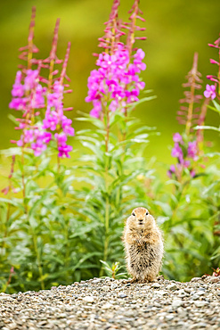
An Arctic Ground Squirrel (Urocitellus parryii) looks at camera while feeding in late summer. Fireweed (Chamaenerion angustifolium) is in bloom in the Hatcher Pass area near Palmer, South-Central Alaska; Alaska, United States of America