Results
35 results found
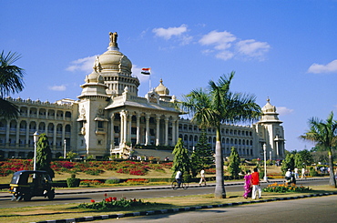
State Legislature & Secretariat building, Bangalore, Karnataka State, India
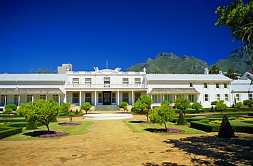
Tuynhuys, Presidential office, Cape Town, South Africa
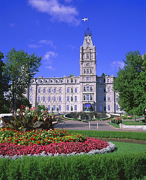
Parliament Building, Quebec City, Quebec, Canada, North America
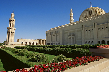
Sultan Qaboos Grand Mosque, built in 2001, with a prayer hall accommodating 20000, Ghubrah, Muscat, Oman, Middle East
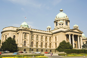
Federal Parliament Building, Belgrade, Serbia, Europe

Casa de Aldeman Ortiz, Plaza Mayor, Trinidad, UNESCO World Heritage Site, Sancti Spiritus, Cuba, West Indies, Central America
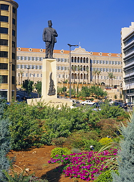
Parliament, Grand Serail, Beirut, Lebanon, Middle East, North Africa
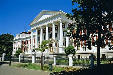
Houses of Parliament, Cape Town, Cape Province, South Africa, Africa
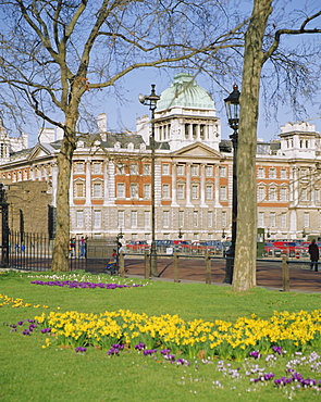
Horse Guards and the Old Admiralty building in spring, London, England, UK
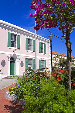
Parliament Building, Nassau, New Providence Island, Bahamas, West Indies, Central America
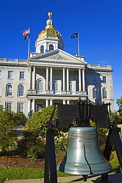
Liberty Bell at the State Capitol, Concord, New Hampshire, New England, United States of America, North America
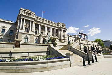
Library of Congress, Washington D.C. (District of Columbia), United States of America, North America
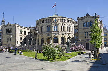
The Parliament building, Oslo, Norway, Scandinavia, Europe
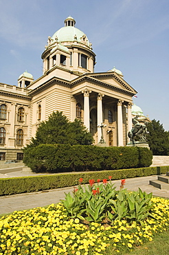
Federal Parliament Building, Belgrade, Serbia, Europe
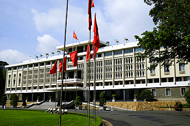
The Reunification (Independence) Palace, formerly building of the South Vietnamese government, Ho Chi Minh City, Vietnam
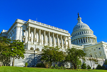
View of the United States Capitol Building, Washington, D.C., United States of America
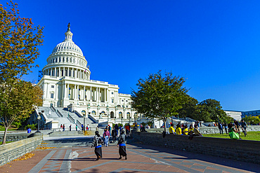
View of the United States Capitol Building, Washington, D.C., United States of America
City Hall of Lourdes, a market town in the Pyrenees, Lourdes, Hautes-Pyrenees, Occitanie, southwestern France
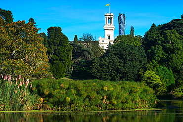
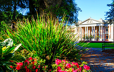
Royal Botanic Gardens with Government House, Melbourne, Victoria, Australia, Pacific
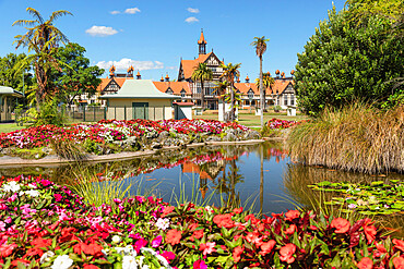
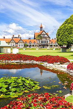
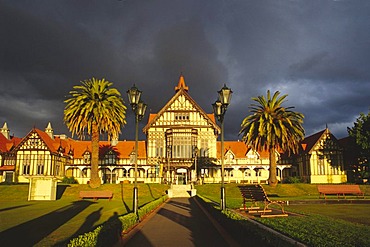
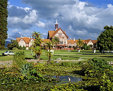
Government Garden, Rotorua, Bay of Plenty, North Island, New Zealand, Pacific
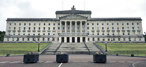
Stormont, Seat of Government, Belfast, Ulster, Northern Ireland, United Kingdom, Europe
Supreme Court Gardens, Perth City, Western Australia, Australia, Pacific

Government Garden, Rotorua, Bay of Plenty, North Island, New Zealand, Pacific
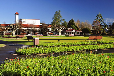
Government Gardens, Rotorua, Bay of Plenty, North Island, New Zealand, Pacific
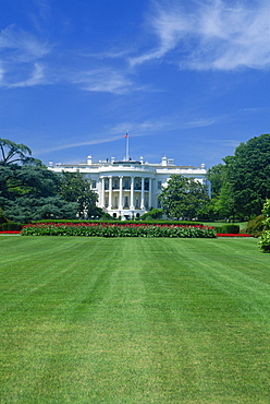
The White House, Washington D.C., United States of America, North America
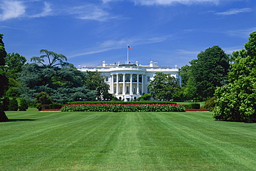
The White House, Washington D.C., United States of America, North America
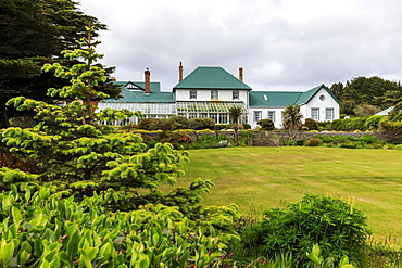
Government House, 1845, conservatory, green iron roof, beautiful grounds, Stanley, Port Stanley, Falkland Islands, South America
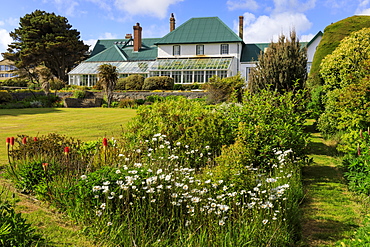
Government House, 1845, conservatory, green iron roof, beautiful grounds, blue sky, Stanley, Port Stanley, Falkland Islands, South America
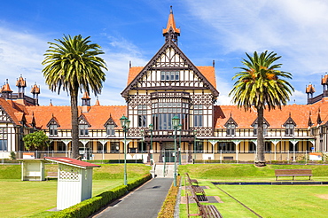
Tudor style Rotorua Museum and Government Gardens, Rotorua, North Island, New Zealand, Pacific
Tudor style Rotorua Museum and Government Gardens, Rotorua, North Island, New Zealand, Pacific

Hotel de Ville (People's Committee Building) with public garden in foreground at dusk, Ho Chi Minh City (Saigon), Vietnam, Indochina, Southeast Asia, Asia
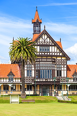
Tudor style Rotorua Museum and Government Gardens, Rotorua, North Island, New Zealand, Pacific
La Mairie, municipal building on the Via Garibaldi, Genoa (Genova), Liguria, Italy, Europe
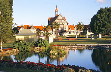
Government Gardens with bath-house dating from 1908, now the Museum of Rotorua, Rotorua, South Auckland, North Island, New Zealand, Pacific

The White House, Washington D.C., United States of America (USA), North America

The Utah State Capitol Building, completed at a cost of 2.7 million dollars in 1916, its rotunda is 165ft tall, the building is home of the Senate and House of Representatives, Salt Lake City, Utah, United States of America (USA), North America
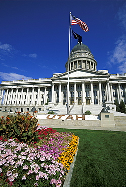
The Utah State Capitol Building, completed at a cost of 2.7 million dollars in 1916, its rotunda is 165ft tall, the building is home of the Senate and House of Representatives, Salt Lake City, Utah, United States of America (USA), North America
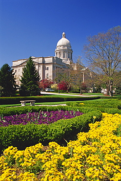
State Capitol Building, Frankfort, Kentucky, United States of America, North America
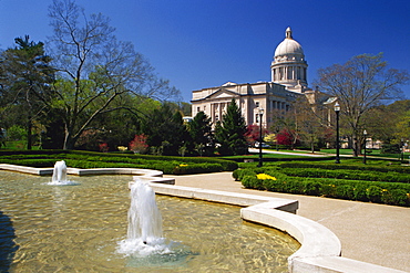
State Capitol Building, Frankfort, Kentucky, United States of America, North America
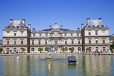
The Senate, Luxembourg Palace, Luxembourg Gardens, Paris, France, Europe
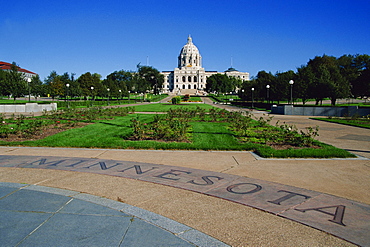
State Capitol, St. Paul, Minnesota, United States of America, North America

03/04/2009. São Jorge government sponsored research centre and Botanic Gardens. Locals carrying hay bails along main road. Praia, São Jorge botanical gardens. , Sao Tiago Island. Cape Verde

03/04/2009. São Jorge government sponsored research centre and Botanic Gardens, Botanic Gardens. Praia, Sao Tiago Island. Cape Verde

Botanic Gardens, Bourganvilia, 03/04/2009. São Jorge government sponsored research centre. Praia, Sao Tiago Island. Cape Verde
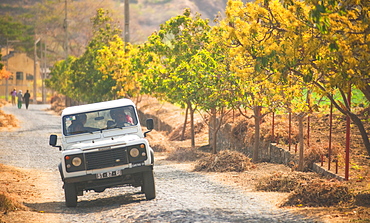
Botanic Gardens, 03/04/2009. São Jorge government sponsored research centre and Botanic Gardens, 4 x 4, strawberry fields. Praia, Sao Tiago Island. Cape Verde
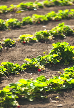
Botanic Gardens, strawberrys, arid soil, 03/04/2009. São Jorge government sponsored research centre. Praia, Sao Tiago Island. Cape Verde
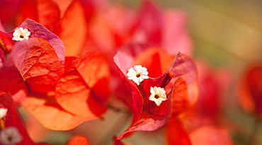
Botanic Gardens, Bourganvilia, 03/04/2009. São Jorge government sponsored research centre. Praia, Sao Tiago Island. Cape Verde
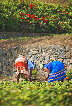
Botanic Gardens, 03/04/2009. São Jorge government sponsored research centre and Botanic Gardens, Women picking strawberries. Praia, Sao Tiago Island. Cape Verde
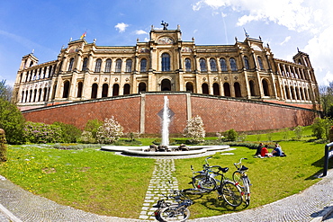
Young people in front of the Maximilianeum, Munich, Upper Bavaria, Germany

View of the Kremlin wall from the Alexander Garden side, Moscow, Russia
Bath House in the Government Gardens, today it hosts the Museum of Art and History, stormy atmosphere, Rotorua, North Island, New Zealand
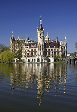
Schweriner Schloss castle, seat of the Landtag parliament of Mecklenburg-Western Pomerania, Federal Garden Show, Schwerin, Mecklenburg-Western Pomerania, Germany, Europe

Aerial view of Unions building and Nelson Mandela garden, offices of the President and Government, Pretoria, South Africa, Africa

View of the Kremlin wall from the side of the Alexander Garden, Moscow, Russia

Castle Bellevue, domicile of the Federal President, Berlin, Germany
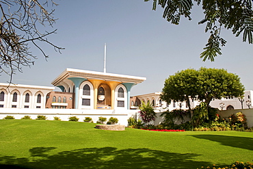
Main building of the Al Alam Palace, as seen from the side across the garden, in Muscat, Oman, Middle East
Bath House, Government Gardens, Museum of Art and History, Rotorua, North Island, New Zealand
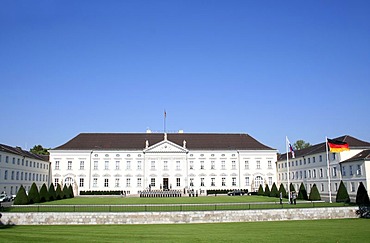
Castle Bellevue, Berlin, Germany

View from the garden, Bundeskanzleramt Federal Chancellery, Berlin, Germany, Europe

View from the garden, Bundeskanzleramt Federal Chancellery, Berlin, Germany, Europe
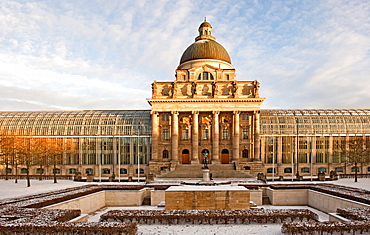
Bavarian State Chancellery at the Court Garden, with the central part of the Bavarian army museum building and its dome integrated that was destroyed during the Second World War, Munich, Bavaria, Germany, Europe
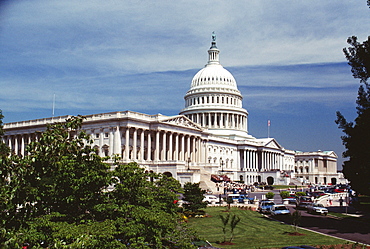
Low angle view of a government building, Capitol Building, Washington DC, USA
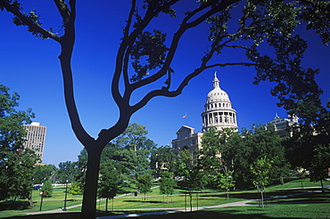
Garden in front of a government building, Texas State Capitol, Texas, USA
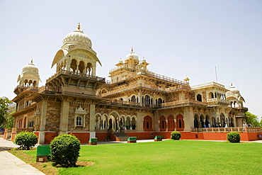
Low angle view of a museum, Government Central Museum, Jaipur, Rajasthan, India

Facade of a government building, Capitol Building, Washington DC, USA

Nimoa Island - here the island mission will impress. The five-sided church features murals of island life and all mission buildings are surrounded by well maintained paths and gardens filled with flowering plants. Edged by jungle-covered mountains, postcard beaches and crystal clear waters - an island paradise indeed! The Louisiade Archipelago is a string of ten larger volcanic islands frequently fringed by coral reefs, and 90 smaller coral islands located 200 km southeast of New Guinea, stretching over more than 160 km and spread over an ocean area of 26,000 km? between the Solomon Sea to the north and the Coral Sea to the south. The aggregate land area of the islands is about 1,790 km? (690 square miles), with Vanatinai (formerly Sudest or Tagula as named by European claimants on Western maps) being the largest. Sideia Island and Basilaki Island lie closest to New Guinea, while Misima, Vanatinai, and Rossel islands lie further east. The archipelago is divided into the Local Level Government (LLG) areas Loui!

Nimoa Island - here the island mission will impress. The five-sided church features murals of island life and all mission buildings are surrounded by well maintained paths and gardens filled with flowering plants. Edged by jungle-covered mountains, postcard beaches and crystal clear waters - an island paradise indeed! The Louisiade Archipelago is a string of ten larger volcanic islands frequently fringed by coral reefs, and 90 smaller coral islands located 200 km southeast of New Guinea, stretching over more than 160 km and spread over an ocean area of 26,000 km? between the Solomon Sea to the north and the Coral Sea to the south. The aggregate land area of the islands is about 1,790 km? (690 square miles), with Vanatinai (formerly Sudest or Tagula as named by European claimants on Western maps) being the largest. Sideia Island and Basilaki Island lie closest to New Guinea, while Misima, Vanatinai, and Rossel islands lie further east. The archipelago is divided into the Local Level Government (LLG) areas Loui!

Nimoa Island - here the island mission will impress. The five-sided church features murals of island life and all mission buildings are surrounded by well maintained paths and gardens filled with flowering plants. Edged by jungle-covered mountains, postcard beaches and crystal clear waters - an island paradise indeed! The Louisiade Archipelago is a string of ten larger volcanic islands frequently fringed by coral reefs, and 90 smaller coral islands located 200 km southeast of New Guinea, stretching over more than 160 km and spread over an ocean area of 26,000 km? between the Solomon Sea to the north and the Coral Sea to the south. The aggregate land area of the islands is about 1,790 km? (690 square miles), with Vanatinai (formerly Sudest or Tagula as named by European claimants on Western maps) being the largest. Sideia Island and Basilaki Island lie closest to New Guinea, while Misima, Vanatinai, and Rossel islands lie further east. The archipelago is divided into the Local Level Government (LLG) areas Louisiade Rural (western part, with Misima), and Yaleyamba (western part, with Rossell and Tagula islands. The LLG areas are part of Samarai-Murua District district of Milne Bay. The seat of the Louisiade Rural LLG is Bwagaoia on Misima Island, the population center of the archipelago.

Nimoa Island - here the island mission will impress. The five-sided church features murals of island life and all mission buildings are surrounded by well maintained paths and gardens filled with flowering plants. Edged by jungle-covered mountains, postcard beaches and crystal clear waters - an island paradise indeed! The Louisiade Archipelago is a string of ten larger volcanic islands frequently fringed by coral reefs, and 90 smaller coral islands located 200 km southeast of New Guinea, stretching over more than 160 km and spread over an ocean area of 26,000 km? between the Solomon Sea to the north and the Coral Sea to the south. The aggregate land area of the islands is about 1,790 km? (690 square miles), with Vanatinai (formerly Sudest or Tagula as named by European claimants on Western maps) being the largest. Sideia Island and Basilaki Island lie closest to New Guinea, while Misima, Vanatinai, and Rossel islands lie further east. The archipelago is divided into the Local Level Government (LLG) areas Louisiade Rural (western part, with Misima), and Yaleyamba (western part, with Rossell and Tagula islands. The LLG areas are part of Samarai-Murua District district of Milne Bay. The seat of the Louisiade Rural LLG is Bwagaoia on Misima Island, the population center of the archipelago.

Nimoa Island - here the island mission will impress. The five-sided church features murals of island life and all mission buildings are surrounded by well maintained paths and gardens filled with flowering plants. Edged by jungle-covered mountains, postcard beaches and crystal clear waters - an island paradise indeed! The Louisiade Archipelago is a string of ten larger volcanic islands frequently fringed by coral reefs, and 90 smaller coral islands located 200 km southeast of New Guinea, stretching over more than 160 km and spread over an ocean area of 26,000 km? between the Solomon Sea to the north and the Coral Sea to the south. The aggregate land area of the islands is about 1,790 km? (690 square miles), with Vanatinai (formerly Sudest or Tagula as named by European claimants on Western maps) being the largest. Sideia Island and Basilaki Island lie closest to New Guinea, while Misima, Vanatinai, and Rossel islands lie further east. The archipelago is divided into the Local Level Government (LLG) areas Louisiade Rural (western part, with Misima), and Yaleyamba (western part, with Rossell and Tagula islands. The LLG areas are part of Samarai-Murua District district of Milne Bay. The seat of the Louisiade Rural LLG is Bwagaoia on Misima Island, the population center of the archipelago.

Nimoa Island - here the island mission will impress. The five-sided church features murals of island life and all mission buildings are surrounded by well maintained paths and gardens filled with flowering plants. Edged by jungle-covered mountains, postcard beaches and crystal clear waters - an island paradise indeed! The Louisiade Archipelago is a string of ten larger volcanic islands frequently fringed by coral reefs, and 90 smaller coral islands located 200 km southeast of New Guinea, stretching over more than 160 km and spread over an ocean area of 26,000 km? between the Solomon Sea to the north and the Coral Sea to the south. The aggregate land area of the islands is about 1,790 km? (690 square miles), with Vanatinai (formerly Sudest or Tagula as named by European claimants on Western maps) being the largest. Sideia Island and Basilaki Island lie closest to New Guinea, while Misima, Vanatinai, and Rossel islands lie further east. The archipelago is divided into the Local Level Government (LLG) areas Loui!
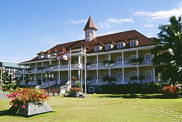
French Polynesia, Tahiti, Papeete, City Hall building downtown, exterior view from distance
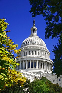
USA, Washington DC, Capitol Building,The building's dome with Statue of Freedom on top seen from Capitol Gardens.
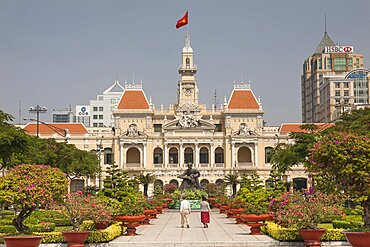
Vietnam, Ho Chi Minh City, Peoples Committee Building formerly Hotel de Ville.

Albania, Tirane, Tirana, Exterior facade of government buildings and Ethem Bey Mosque on Skanderbeg Square.

White house

White house