Results
2 results found
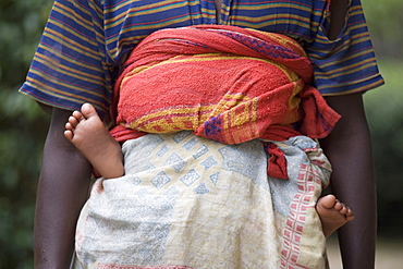
Village of Masango, Cibitoke Province, Burundi, Africa
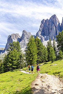
Hikers walking on the Adolf Munkel trail at foot of the Odle, Val di Funes, South Tyrol, Dolomites, Italy, Europe

Mother playing with feet of baby daughter laying on bed

Black woman standing on one leg holding foot

Mixed Race woman leaning on banister stretching leg
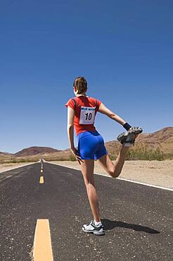
Mixed Race female runner stretching

Mixed race athlete stretching outdoors

Father kissing feet of baby son on bed

Mother playing with feet of baby son laying on bed

African American man stretching leg on bleachers

African American man stretching leg on bleachers

Caucasian artist relaxing with feet on table

Caucasian mother holding foot of baby son

Caucasian mother painting toenails of daughter on staircase

Caucasian woman stretching on gymnasium floor

Expectant mother taking cell phone selfie on floor with Caucasian daughter

Caucasian mother holding baby son in lap

Mixed Race woman standing on balance trainer in gymnasium

Mother holding baby son in lap

Mother kissing foot of baby son

Mixed Race woman stretching legs on floor at gymnasium

Mixed race athlete stretching outdoors
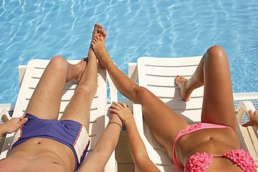
Young couple at a swimming pool, detail of the legs
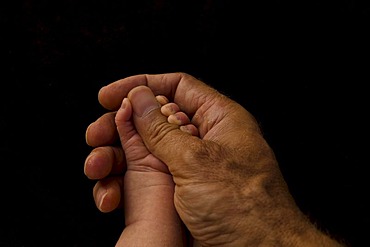
Father's hand holding baby's hand

Family holiday in summer. Young Caucasian family foot walking barefoot sandy beach, shore river water. Dad mom holding hands two children, brothers. Big friendly family with two children near lake

Three participants of the UTMB are running in the hills of Chamonix. The famous peaks of the Mont Blanc range are in the background. The Ultra-Trail du Mont-Blanc (also referred to as UTMB) is a single-stage mountain ultramarathon. It takes place once a year in the Alps, across France, Italy and Switzerland. The distance is approximately 166 kilometres (103 mi), with a total elevation gain of around 9,600 m. It is widely regarded as one of the most difficult foot races in Europe. It's certainly one of the largest with over two thousand starters. The combined participation in all of the events is approaching 10 thousand runners. While the best runners complete the loop in slightly more than 20 hours, most runners take 30 to 45 hours to reach the finish line.

Entrance arch to Santa Monica Pier, from the Pacific Coast Highway. A popular excursion spot for more than a century, the Santa Monica Pier draws crowds daily. From Wikipedia: "The Santa Monica Pier is a large double-jointed pier located at the foot of Colorado Avenue in Santa Monica, California and is a prominent, 100-year-old landmark. The pier contains Pacific Park, a family amusement park with its one-of-a-kind, state-of-the-art, solar paneled Ferris wheel. It also has an original carousel hippodrome from the 1920s, the Santa Monica Pier Aquarium operated by Heal the Bay, shops, entertainers, a video arcade, a trapeze school, pubs, and restaurants. The west end of the pier is a popular location for anglers.

Male hiker filters water on a cliff-pinched patio near Deer Creek Falls in the Grand Canyon outside of Fredonia, Arizona November 2011. The 21.4-mile loop starts at the Bill Hall trailhead on the North Rim and descends 2000-feet in 2.5-miles through Coconino Sandstone to the level Esplanada then descends further into the lower canyon through a break in the 400-foot-tall Redwall to access Surprise Valley. Hikers connect Thunder River and Tapeats Creek to a route along the Colorado River and climb out Deer Creek.
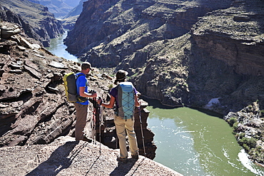
Hikers overlook the Colorado River as they exit the Deer Creek Narrows in the Grand Canyon outside of Fredonia, Arizona November 2011. The 21.4-mile loop starts at the Bill Hall trailhead on the North Rim and descends 2000-feet in 2.5-miles through Coconino Sandstone to the level Esplanada then descends further into the lower canyon through a break in the 400-foot-tall Redwall to access Surprise Valley. Hikers connect Thunder River and Tapeats Creek to a route along the Colorado River and climb out Deer Creek.
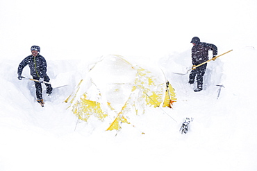
Two climbers dig out their tent after a snowstorm covered them in 14k camp on Mount McKinley, Alaska. Climbers are advised to spare no expense on a expedition-quality tent as it can mean the difference between life and death during a ferocious storm on Denali. Extra poles and repair materials are important in case of damage caused by storms. Plan to take extra pickets, wands or deadmen for tent anchors. Never leave a tent without anchoring it securely. Tents are lost each year due to sudden gusts of wind while the tent was left unattended or drying. Every climbing season High Mountain Rangers of the Denali National Park Service are called to help climbers in need. If possible the patient is brought down to base camp on foot, only in life threatening conditions a helicopter is called to evacuate the patient to a hospital in Anchorage.
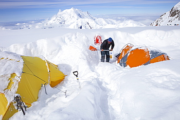
A mountain ranger is digging out tents after a snowstorm covered them during the night in 14k camp on Mount McKinley, Alaska. Climbers are advised to spare no expense on a expedition-quality tent as it can mean the difference between life and death during a ferocious storm on Denali. Extra poles and repair materials are important in case of damage caused by storms. Plan to take extra pickets, wands or deadmen for tent anchors. Never leave a tent without anchoring it securely. Tents are lost each year due to sudden gusts of wind while the tent was left unattended or drying. Every climbing season High Mountain Rangers of the Denali National Park Service are called to help climbers in need. If possible the patient is brought down to base camp on foot, only in life threatening conditions a helicopter is called to evacuate the patient to a hospital in Anchorage.
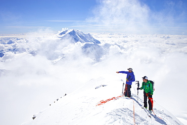
High Mountain Rangers Tom Ditola and David Weber are taking a rest on the West Rib on Mount McKinley, Alaska. Mount Hunter in the background. They are above the clouds in blue sky and the sun is shining. Mount McKinley, native name Denali, is the highest mountain peak in North America, with a summit elevation of 20,321 feet (6,194 m) above sea level. At some 18,000 feet (5,500 m), the base-to-peak rise is considered the largest of any mountain situated entirely above sea level. Measured by topographic prominence, it is the third most prominent peak after Mount Everest and Aconcagua. Located in the Alaska Range in the interior of the U.S. state of Alaska, McKinley is the centerpiece of Denali National Park and Preserve. Every climbing season High Mountain Rangers of the Denali National Park Service are called to help climbers in need. If possible the patient is brought down to base camp on foot, only in life threatening conditions a helicopter is called to evacuate the patient to a hospital in Anchorage.
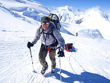
Mountain ranger Brian Scheele on this way to Windy Corner on Mount McKinley, also know as Denali, in Alaska. He is pulling a sled, that together with his heavy backpack is containing all the gear like tents, clothing and food. Every climbing season High Mountain Rangers of the Denali National Park Service are called to help climbers in need. If possible the patient is brought down to Basecamp on foot, only in life threatening conditions a helicopter is called to evacuate the patient to a hospital in Anchorage. Mount McKinley, native name Denali, is the highest mountain peak in North America, with a summit elevation of 20,321 feet (6,194 m) above sea level. At some 18,000 feet (5,500 m), the base-to-peak rise is considered the largest of any mountain situated entirely above sea level. Measured by topographic prominence, it is the third most prominent peak after Mount Everest and Aconcagua. Located in the Alaska Range in the interior of the U.S. state of Alaska, McKinley is the centerpiece of Denali National Park and Preserve.
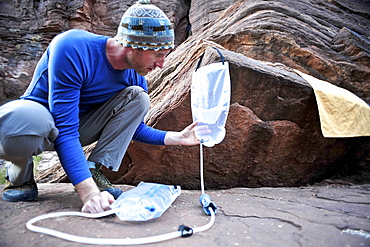
Male hiker filters water on a cliff-pinched patio near Deer Creek Falls in the Grand Canyon outside of Fredonia, Arizona November 2011. The 21.4-mile loop starts at the Bill Hall trailhead on the North Rim and descends 2000-feet in 2.5-miles through Coconino Sandstone to the level Esplanada then descends further into the lower canyon through a break in the 400-foot-tall Redwall to access Surprise Valley. Hikers connect Thunder River and Tapeats Creek to a route along the Colorado River and climb out Deer Creek.
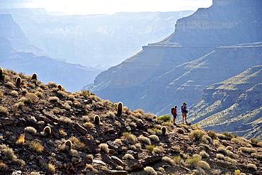
Hikers on the sandstone Esplanade of the Thunder River Trail below the North Rim of the Grand Canyon outside Fredonia, Arizona November 2011. The 21.4-mile loop descends 2000-feet in 2.5-miles through Coconino Sandstone from the Bill Hall trailhead to connect the Thunder River and Deer Creeks trails. Hikers descend into the lower canyon through a break in the 400-foot-tall Redwall to access Surprise Valley, Deer Creek, Tapeats Creek via Thunder River and even the Colorado River.
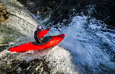
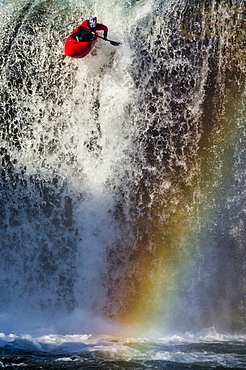
Spanish whitewater kayaker drops down the 40-foot "Tobalina Falls" in Pedrosa de Tobalina, Spain.
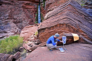
Male hiker filters water on a cliff-pinched patio near Deer Creek Falls in the Grand Canyon outside of Fredonia, Arizona November 2011. The 21.4-mile loop starts at the Bill Hall trailhead on the North Rim and descends 2000-feet in 2.5-miles through Coconino Sandstone to the level Esplanada then descends further into the lower canyon through a break in the 400-foot-tall Redwall to access Surprise Valley. Hikers connect Thunder River and Tapeats Creek to a route along the Colorado River and climb out Deer Creek.
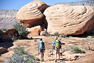
Hikers on the sandstone Esplanade of the Thunder River Trail below the North Rim of the Grand Canyon outside Fredonia, Arizona November 2011. The 21.4-mile loop descends 2000-feet in 2.5-miles through Coconino Sandstone from the Bill Hall trailhead to connect the Thunder River and Deer Creeks trails. Hikers descend into the lower canyon through a break in the 400-foot-tall Redwall to access Surprise Valley, Deer Creek, Tapeats Creek via Thunder River and even the Colorado River.
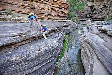
Hikers walk along Deer Creek Narrows in the Grand Canyon outside of Fredonia, Arizona November 2011. The 21.4-mile loop starts at the Bill Hall trailhead on the North Rim and descends 2000-feet in 2.5-miles through Coconino Sandstone to the level Esplanada then descends further into the lower canyon through a break in the 400-foot-tall Redwall to access Surprise Valley. Hikers connect Thunder River and Tapeats Creek to a route along the Colorado River and climb out Deer Creek.
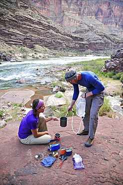
Hikers cook dinner on a cliff-pinched patio above camp and the Colorado River near Deer Creek Falls in the Grand Canyon outside of Fredonia, Arizona November 2011. The 21.4-mile loop starts at the Bill Hall trailhead on the North Rim and descends 2000-feet in 2.5-miles through Coconino Sandstone to the level Esplanada then descends further into the lower canyon through a break in the 400-foot-tall Redwall to access Surprise Valley. Hikers connect Thunder River and Tapeats Creek to a route along the Colorado River and climb out Deer Creek.
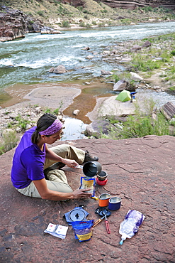
Female hiker cooks dinner on a cliff-pinched patio above camp and the Colorado River near Deer Creek Falls in the Grand Canyon outside of Fredonia, Arizona November 2011. The 21.4-mile loop starts at the Bill Hall trailhead on the North Rim and descends 2000-feet in 2.5-miles through Coconino Sandstone to the level Esplanada then descends further into the lower canyon through a break in the 400-foot-tall Redwall to access Surprise Valley. Hikers connect Thunder River and Tapeats Creek to a route along the Colorado River and climb out Deer Creek.
Hikers follow a route along the Colorado River that connect Tapeats Creek and Thunder River to Deer Creek in the Grand Canyon outside of Fredonia, Arizona November 2011. The 21.4-mile loop starts at the Bill Hall trailhead on the North Rim and descends 2000-feet in 2.5-miles through Coconino Sandstone to the level Esplanada then descends further into the lower canyon through a break in the 400-foot-tall Redwall to access Surprise Valley. Hikers connect Thunder River and Tapeats Creek to a route along the Colorado River and climb out Deer Creek.
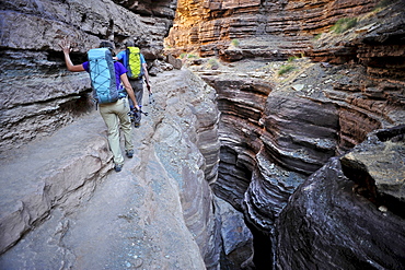
Hikers walk along Deer Creek Narrows in the Grand Canyon outside of Fredonia, Arizona November 2011. The 21.4-mile loop starts at the Bill Hall trailhead on the North Rim and descends 2000-feet in 2.5-miles through Coconino Sandstone to the level Esplanada then descends further into the lower canyon through a break in the 400-foot-tall Redwall to access Surprise Valley. Hikers connect Thunder River and Tapeats Creek to a route along the Colorado River and climb out Deer Creek.
Spanish whitewater kayaker drops down the 40-foot "Tobalina Falls" in Pedrosa de Tobalina, Spain.
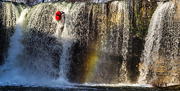
Spanish whitewater kayaker drops down the 40-foot "Tobalina Falls" in Pedrosa de Tobalina, Spain.
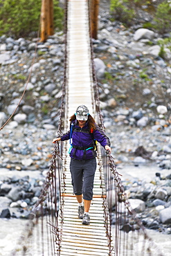
Female hiker crosses a wooden foot bridge on her way to Gulkana Glacier, Alaska, United States of America
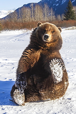
Grizzly bear (Ursus arctos horribilis) is holding up her snowy paw and looking at camera, captive. Alaska Wildlife Conservation Center, Portage, Alaska, United States of America
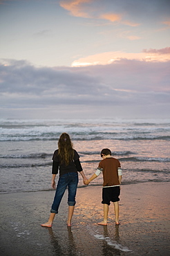
A Mother And Son Hold Hands On A Beach Looking Out At The Water

Wedding rings on a newborn babies toes, Surrey, British Columbia, Canada
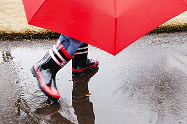
Wellingtons and umbrella
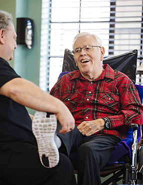
Nurse holding smiling senior man's foot in wheelchair
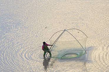
Fishermen on foot, shrimp fishing with net, Xiapu County, Fujiang Province, China
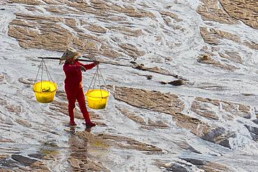
Fisherman on foot, harvesting shells, wearing a yoke with two buckets, Woman, Xiapu County, Fujiang Province, China
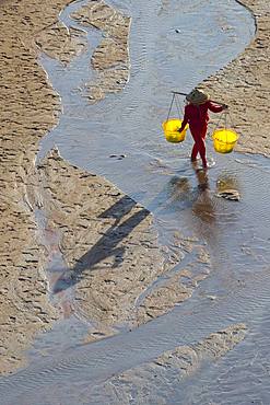
Fisherman on foot, harvesting shells, wearing a yoke with two buckets, Woman, Xiapu County, Fujiang Province, China
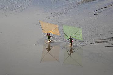
Fishermen on foot, shrimp fishing with net, Xiapu County, Fujiang Province, China