Results
59 results found
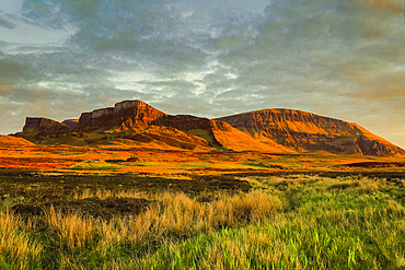
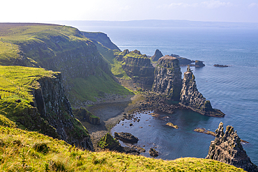
The Trotternish Ridge, a major geological feature of lava flows over Jurassic sediments, a major scenic attraction in the far north east of the island at sunset Golden hour, Flodigarry, Trotternish Peninsula, Skye, Inner Hebrides, Scotland, United Kingdom, Europe
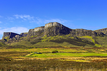
The Trotternish Ridge north of the Quiraing, a major geological feature of lava flows over Jurassic sediments, a major scenic attraction in the far north east of the island, Flodigarry, Trotternish Peninsula, Skye, Inner Hebrides, Scotland, United Kingdom, Europe
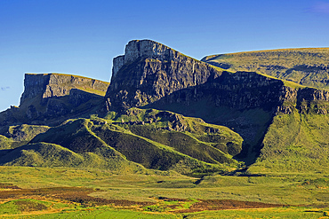
The Trotternish Ridge north of the Quiraing, a major geological feature of lava flows over Jurassic sediments and major scenic attraction in the far north east of the island, Flodigarry, Trotternish Peninsula, Skye, West Inner Hebrides, Scotland, United Kingdom, Europe
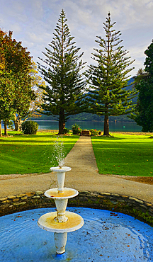
Furneaux Lodge, Marlborough Sound, South Island, New Zealand
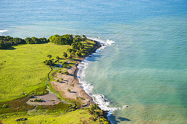
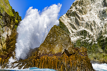
Aerial view of 'Pointe Allegre' (the northest headland of Basse-Terre), Grand Cul-de-sac Marin, Sainte-Rose, Basse-Terre, Guadeloupe
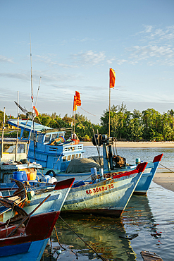
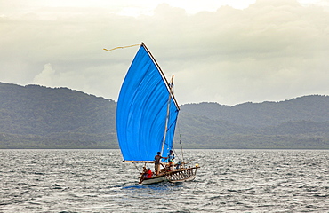
Fishing Boats, Le Bat, Phu Quoc Island, Vietnam
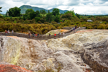
Walking paths through a volcano landscape in Waiotapu Thermal Wonderland, North Island, New Zealand
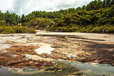
Waiotapu Thermal Wonderland, North Island, New Zealand
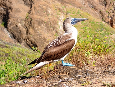
Blue Footed Booby (Sula nebouxii), a marine bird found in the Eastern Pacific whose unusual blue feet feature in courtship rituals, Galapagos, UNESCO World Heritage Site, Ecuador, South America
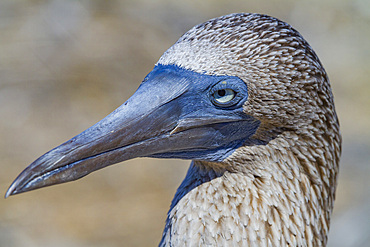
Adult blue-footed booby (Sula nebouxii) in the Galapagos Island Archipelago, UNESCO World Heritage Site, Ecuador, South America
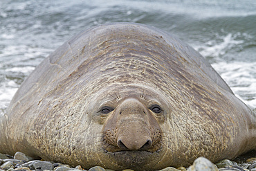
Bull southern elephant seal (Mirounga leonina) on South Georgia Island, Southern Ocean
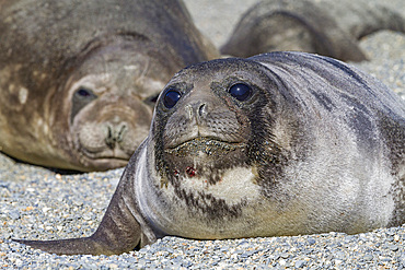
Southern elephant seal (Mirounga leonina) pup, called weaners once their mothers stop nursing, South Georgia Island, Southern Ocean
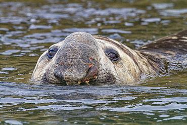
Bull southern elephant seal (Mirounga leonina) on South Georgia Island, Southern Ocean
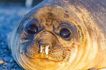
Southern elephant seal (Mirounga leonina) pup, called weaners once their mothers stop nursing, South Georgia Island, Southern Ocean
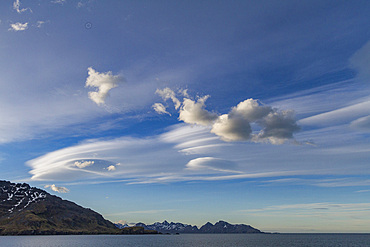
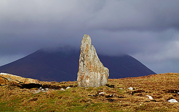
Interesting lenticular cloud formations forming over the island of South Georgia in the Southern Ocean
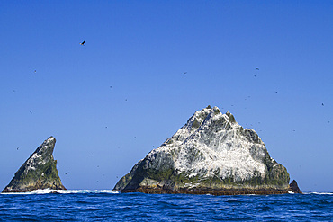
Shag Rocks, Scotia Sea, South Atlantic Ocean
Very remote Shag Rocks, near South Georgia Island in the Scotia Sea, South Atlantic Ocean
Coastal scenery on Achill Island, Co Mayo, Ireland
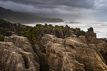
Layered Limestone Columns of Pancake Rocks With Misty Coastline in the Background, Paparoa National Park, New Zealand
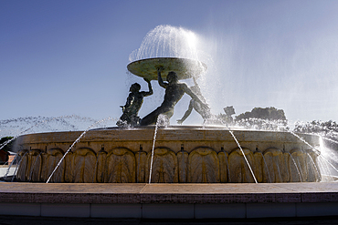
Triton Fountain, Valletta, Malta
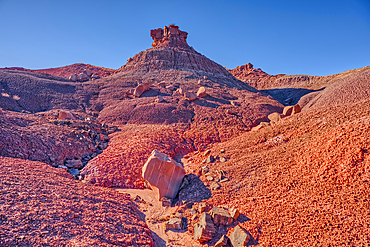
An island of rock in an unnamed canyon that leads to Dead Wash in Petrified Forest National Park, Arizona, United States of America
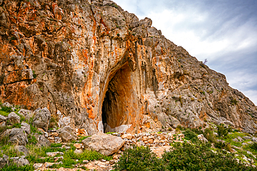
Cave of Elafonisos island with orange rock color painted in white, Greece
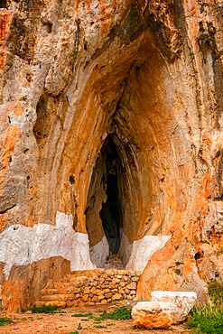
Cave of Elafonisos island with orange rock color painted in white, Greece
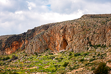
Cave of Elafonisos island with orange rock color painted in white, Greece
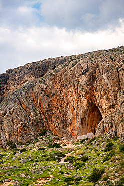
Cave of Elafonisos island with orange rock color painted in white, Greece
The spectacular scenery on the island of Madeira, Atlantic Ocean, Portugal
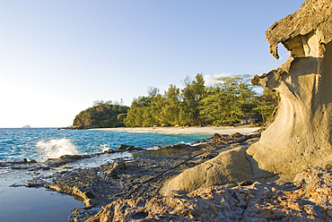
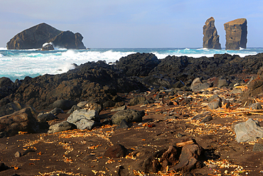
Rocky part of the coast at Tsarabanjina island, Mitsio archipelago, Republic of Madagascar, Indian Ocean
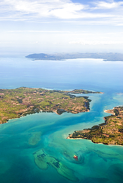
Aerial view over Ambato cape, Nosy Faly island and Nosy Be background , Republic of Madagascar, Indian Ocean
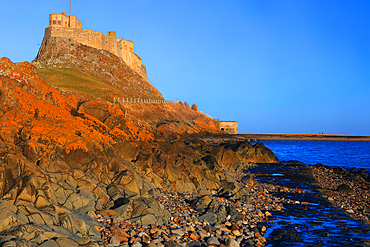
Lindisfarne Castle, Holy Island, Northumberland, England
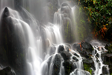
Ribera dos Caldeiroes waterfalls, near Achada, Sao Miguel, Azores Islands, Atlantic, Portugal
Mosteiros and coast, Sao Miguel, Azores Islands, Atlantic, Portugal
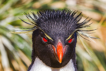
Adult rockhopper penguin (Eudyptes chrysocome chrysocome) at breeding and molting colony on New Island, Falkland Islands
Basalt columns and sea cliffs, Rathlin Island, County Antrim, Ulster, Northern Ireland, United Kingdom
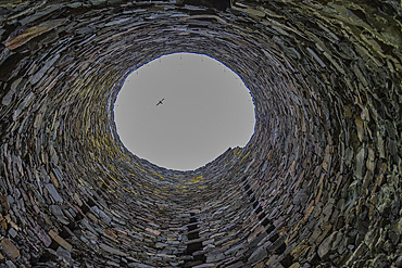
View of the interior of Mousa Broch on Mousa Island in Shetland, Scotland, United Kingdom
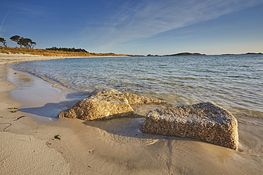
Granite boulders, a typical feature of the Isles of Scilly, seen along the shore in Pentle Bay, on the island of Tresco, Isles of Scilly, England, United Kingdom, Europe
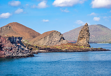
Pinnacle Rock, a volcanic plug on Bartolome Island, one of the most spectacular features of the Galapagos islands, UNESCO World Heritage Site, Ecuador, South America
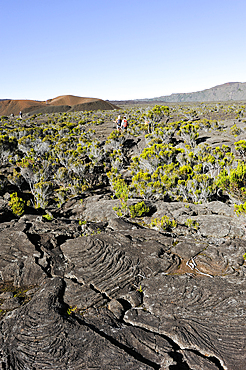
Hikers inside the caldera Enclos Fouque, Piton de la Fournaise, Reunion
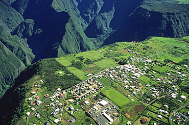
Cilaos River canyon, Reunion
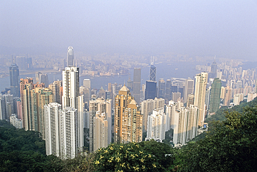
A view from Victoria Peak, looking north over Central district, the harbour and Kowloon,Hong-Kong Island,People's Republic of China,Asia
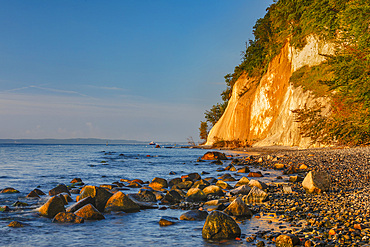
Chalk cliffs, Jasmund National Park, Sassnitz, Rügen Island, Mecklenburg-Western Pomerania, Germany

Famous Palombaggia beach with rocks at sunset, Island of Corsica, France
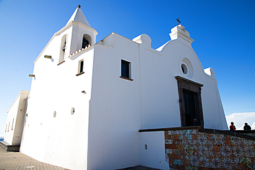
White church in Forio, Ischia, Phlegrean Islands, Gulf of Naples, Campania, Italy
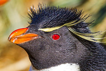
Adult rockhopper penguin (Eudyptes chrysocome chrysocome) at breeding and molting colony on New Island, Falkland Islands
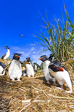
Adult rockhopper penguins (Eudyptes chrysocome chrysocome) at breeding and molting colony on New Island, Falkland Islands
Te Pae, Christchurch Convention Centre, South Island, New Zealand
Luxurious hotel Le Saint Alexis, Boucan Canot beach, Saint-Gilles-les-Bains, Reunion
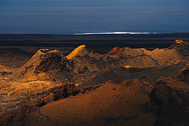
Piton de la Fournaise volcano, Reunion

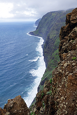
North Coast, Madeira

View from summit of Pico do Areeiro, Madeira
View of New Island in the Falkland Islands

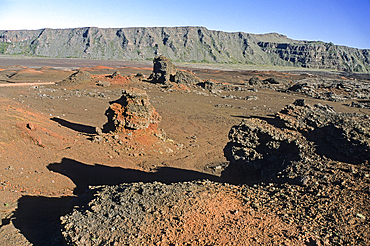
The spectacular scenery of the north coast and volcanic highlands of Saint Anthony, Cape Verde

The spectacular scenery of the north coast and volcanic highlands of Saint Anthony, Cape Verde
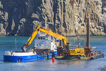
Dredging the harbor on remote Heimaey Island, Iceland
view of Volcanoes and the Volcanic landscape with the Atlantic Ocean in the Timanfaya national park in Lanzarote in the Canary Islands, Spain

View over the fjords Steinfjorden and Ersfjorden from Husfjellet mountain, Senja island, County of Troms, Norway, Northern Europe
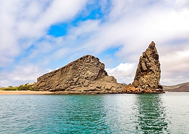
Pinnacle Rock, a volcanic plug on Bartolome Island, one of the most spectacular features of the Galapagos Islands, UNESCO World Heritage Site, Ecuador, South America
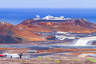
View of Wideawake Airfield on Ascension Island in the southern tropical Atlantic Ocean, South Atlantic Ocean
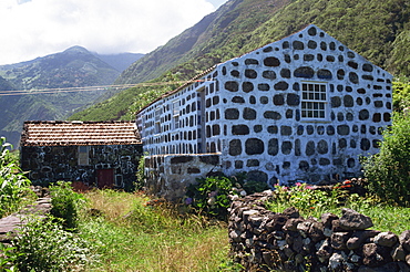
Whitewash between stone, a typical feature of buildings on the island, Sao Jorge, Azores, Portugal, Europe
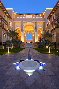
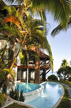
Water feature and architecture at night of luxury hotel, Saadiyat island, Abu Dhabi, United Arab Emirates, Middle East
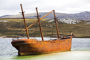
The shipwreck of the Lady Elizabeth on the outskirts of Port Stanley, the capital of the Falkland Islands.
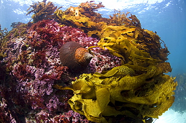
Jourdan's turban (turbo jourdani) large gastropod shell, reddish-brown, Rottnest Island reef, wild, day, marine protected area, free-diving off, cool temperate waters of Western Australia. MORE INFO: Marine plant common kelp, a dominant feature of the underwater landscape. Protected areas are covered in lush growth of diverse algae, also red algea are here.
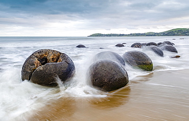
Moeraki Boulders, geological feature, round rock balls, washed by the waves of the surf at high tide, Coastal Otago, Moeraki, South Island, New Zealand, Oceania
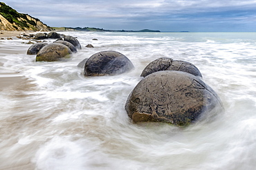
Moeraki Boulders, geological feature, round rock balls, washed by the waves of the surf at high tide, Coastal Otago, Moeraki, South Island, New Zealand, Oceania
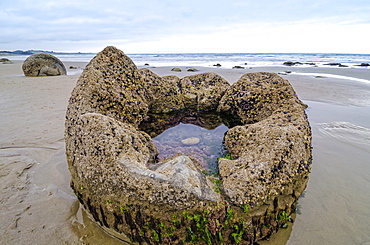
Moeraki Boulders, geological feature, round rock balls, some fragments lying broken in ruins on the beach, Coastal Otago, Moeraki, South Island, New Zealand, Oceania
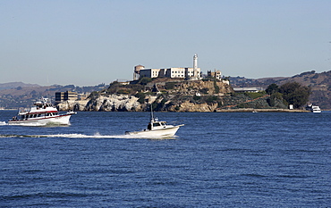
The Isle Alcatraz, a jailhouse, in front of San Francisco, California, USA
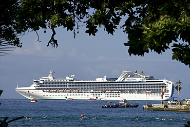
Cruise line at the coast of Big Island, Hawaii, USA

Garden, water feature, manor house, open air museum, La Granja, Esporles, Majorca, Balearic Islands, Spain, Europe
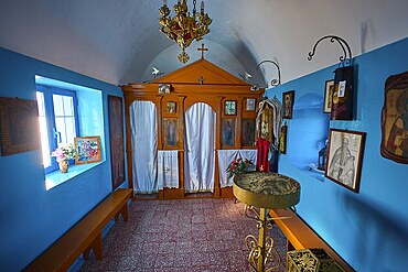
The interior of the church features icons and decorative elements in blue and orange, chapel, church, Agios Isidoros, rocky islet, Gourna Bay, Kokkali, Leros, Dodecanese, Greek Islands, Greece
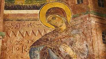
Detail of a fresco with Mary and gentle facial features, monastery, Moni Thari, near Gadouras reservoir, lonely mountain region, Rhodes, Dodecanese, Greek Islands, Greece, Europe
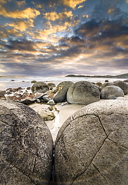
Moeraki Boulders, geological feature, round rock balls, some fragments lying broken in ruins on the beach, Coastal Otago, Moeraki, South Island, New Zealand, Oceania

Nimoa Island - here the island mission will impress. The five-sided church features murals of island life and all mission buildings are surrounded by well maintained paths and gardens filled with flowering plants. Edged by jungle-covered mountains, postcard beaches and crystal clear waters - an island paradise indeed! The Louisiade Archipelago is a string of ten larger volcanic islands frequently fringed by coral reefs, and 90 smaller coral islands located 200 km southeast of New Guinea, stretching over more than 160 km and spread over an ocean area of 26,000 km? between the Solomon Sea to the north and the Coral Sea to the south. The aggregate land area of the islands is about 1,790 km? (690 square miles), with Vanatinai (formerly Sudest or Tagula as named by European claimants on Western maps) being the largest. Sideia Island and Basilaki Island lie closest to New Guinea, while Misima, Vanatinai, and Rossel islands lie further east. The archipelago is divided into the Local Level Government (LLG) areas Loui!

Nimoa Island - here the island mission will impress. The five-sided church features murals of island life and all mission buildings are surrounded by well maintained paths and gardens filled with flowering plants. Edged by jungle-covered mountains, postcard beaches and crystal clear waters - an island paradise indeed! The Louisiade Archipelago is a string of ten larger volcanic islands frequently fringed by coral reefs, and 90 smaller coral islands located 200 km southeast of New Guinea, stretching over more than 160 km and spread over an ocean area of 26,000 km? between the Solomon Sea to the north and the Coral Sea to the south. The aggregate land area of the islands is about 1,790 km? (690 square miles), with Vanatinai (formerly Sudest or Tagula as named by European claimants on Western maps) being the largest. Sideia Island and Basilaki Island lie closest to New Guinea, while Misima, Vanatinai, and Rossel islands lie further east. The archipelago is divided into the Local Level Government (LLG) areas Loui!

Nimoa Island - here the island mission will impress. The five-sided church features murals of island life and all mission buildings are surrounded by well maintained paths and gardens filled with flowering plants. Edged by jungle-covered mountains, postcard beaches and crystal clear waters - an island paradise indeed! The Louisiade Archipelago is a string of ten larger volcanic islands frequently fringed by coral reefs, and 90 smaller coral islands located 200 km southeast of New Guinea, stretching over more than 160 km and spread over an ocean area of 26,000 km? between the Solomon Sea to the north and the Coral Sea to the south. The aggregate land area of the islands is about 1,790 km? (690 square miles), with Vanatinai (formerly Sudest or Tagula as named by European claimants on Western maps) being the largest. Sideia Island and Basilaki Island lie closest to New Guinea, while Misima, Vanatinai, and Rossel islands lie further east. The archipelago is divided into the Local Level Government (LLG) areas Louisiade Rural (western part, with Misima), and Yaleyamba (western part, with Rossell and Tagula islands. The LLG areas are part of Samarai-Murua District district of Milne Bay. The seat of the Louisiade Rural LLG is Bwagaoia on Misima Island, the population center of the archipelago.
Nimoa Island - here the island mission will impress. The five-sided church features murals of island life and all mission buildings are surrounded by well maintained paths and gardens filled with flowering plants. Edged by jungle-covered mountains, postcard beaches and crystal clear waters - an island paradise indeed! The Louisiade Archipelago is a string of ten larger volcanic islands frequently fringed by coral reefs, and 90 smaller coral islands located 200 km southeast of New Guinea, stretching over more than 160 km and spread over an ocean area of 26,000 km? between the Solomon Sea to the north and the Coral Sea to the south. The aggregate land area of the islands is about 1,790 km? (690 square miles), with Vanatinai (formerly Sudest or Tagula as named by European claimants on Western maps) being the largest. Sideia Island and Basilaki Island lie closest to New Guinea, while Misima, Vanatinai, and Rossel islands lie further east.

Nimoa Island - here the island mission will impress. The five-sided church features murals of island life and all mission buildings are surrounded by well maintained paths and gardens filled with flowering plants. Edged by jungle-covered mountains, postcard beaches and crystal clear waters - an island paradise indeed! The Louisiade Archipelago is a string of ten larger volcanic islands frequently fringed by coral reefs, and 90 smaller coral islands located 200 km southeast of New Guinea, stretching over more than 160 km and spread over an ocean area of 26,000 km? between the Solomon Sea to the north and the Coral Sea to the south. The aggregate land area of the islands is about 1,790 km? (690 square miles), with Vanatinai (formerly Sudest or Tagula as named by European claimants on Western maps) being the largest. Sideia Island and Basilaki Island lie closest to New Guinea, while Misima, Vanatinai, and Rossel islands lie further east. The archipelago is divided into the Local Level Government (LLG) areas Louisiade Rural (western part, with Misima), and Yaleyamba (western part, with Rossell and Tagula islands. The LLG areas are part of Samarai-Murua District district of Milne Bay. The seat of the Louisiade Rural LLG is Bwagaoia on Misima Island, the population center of the archipelago.

Nimoa Island - here the island mission will impress. The five-sided church features murals of island life and all mission buildings are surrounded by well maintained paths and gardens filled with flowering plants. Edged by jungle-covered mountains, postcard beaches and crystal clear waters - an island paradise indeed! The Louisiade Archipelago is a string of ten larger volcanic islands frequently fringed by coral reefs, and 90 smaller coral islands located 200 km southeast of New Guinea, stretching over more than 160 km and spread over an ocean area of 26,000 km? between the Solomon Sea to the north and the Coral Sea to the south. The aggregate land area of the islands is about 1,790 km? (690 square miles), with Vanatinai (formerly Sudest or Tagula as named by European claimants on Western maps) being the largest. Sideia Island and Basilaki Island lie closest to New Guinea, while Misima, Vanatinai, and Rossel islands lie further east. The archipelago is divided into the Local Level Government (LLG) areas Louisiade Rural (western part, with Misima), and Yaleyamba (western part, with Rossell and Tagula islands. The LLG areas are part of Samarai-Murua District district of Milne Bay. The seat of the Louisiade Rural LLG is Bwagaoia on Misima Island, the population center of the archipelago.

Nimoa Island - here the island mission will impress. The five-sided church features murals of island life and all mission buildings are surrounded by well maintained paths and gardens filled with flowering plants. Edged by jungle-covered mountains, postcard beaches and crystal clear waters - an island paradise indeed! The Louisiade Archipelago is a string of ten larger volcanic islands frequently fringed by coral reefs, and 90 smaller coral islands located 200 km southeast of New Guinea, stretching over more than 160 km and spread over an ocean area of 26,000 km? between the Solomon Sea to the north and the Coral Sea to the south. The aggregate land area of the islands is about 1,790 km? (690 square miles), with Vanatinai (formerly Sudest or Tagula as named by European claimants on Western maps) being the largest. Sideia Island and Basilaki Island lie closest to New Guinea, while Misima, Vanatinai, and Rossel islands lie further east. The archipelago is divided into the Local Level Government (LLG) areas Loui!
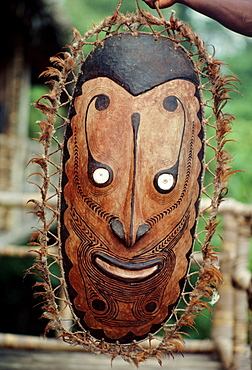
Papua New Guinea, Sepik River, Tribal mask of local native culture
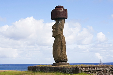
The moai of Ahu Ko te Riku at the Tahai Ceremonial Complex statue, restored by William Mulloy is the only statue to feature inlaid eyes. Hubert Herzog and Tony Saulnier had the pukao (top knot) cut and put in place, Rapa Nui (Easter Island), Chile
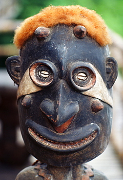
Papua New Guinea, close-up of wood statue, opossum fur on head

New Zealand, North Island, Rotorua Thermal Pools with Maori girls in traditional dress
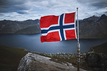
Norway, Senja, Norwegian flag with fjord and mountains in background

Norway, Senja, Man and two tents near Segla mountain at sunset

Norway, Senja, Panoramic view of Segla mountain at sunrise
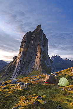
Norway, Senja, Two tents near Segla mountain at sunset