Results
26 results found
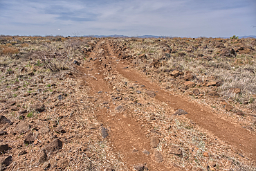
A primitive road in the Agua Fria National Monument that branches off from Forest Service Road 9023 near Silver Creek Canyon Arizona
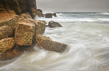
Atlantic surf rolls across granite shoreline rocks, at Porthgwarra Cove, near Land's End, in the far west of Cornwall, Great Britain.
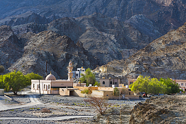
Al Bardah, village on edge of Wadi Bani Awf, NE slope of Jebel Akhdar, Western Hajar Mountains, Al-Dakhiliyah region, Oman, Arabian Peninsula
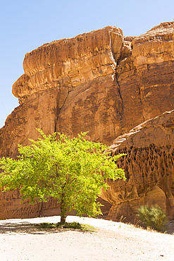
Isolated tree among sandstone rock formation in the desert canyons of the Ashar Valley, Medina Province, Saudi Arabia
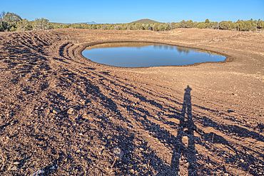
The Thirteen Mile Cattle Tank off of Corva Road in the Kaibab National Forest near Ash Fork Arizona, USA
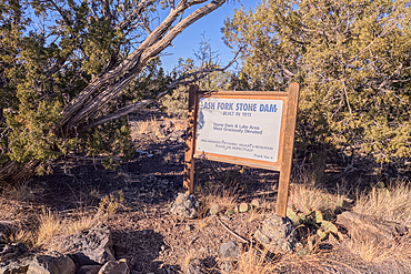
Historical information sign at Stone Dam Lake in the Kaibab National Forest, Arizona, USA
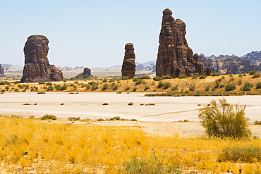
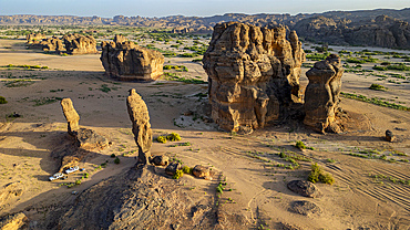
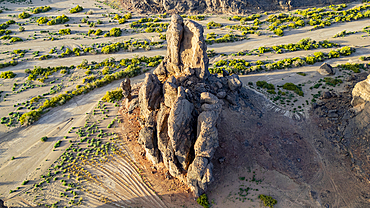
Sandstone rock tower beside a large dry salt lake in the Sharaan Nature Reserve, AlUla, Medina Province, Saudi Arabia
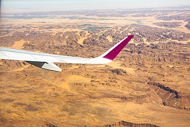
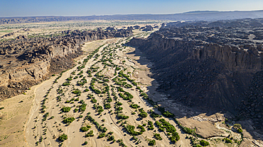
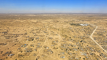
Aerial view from an aircraft of the desert in AlUla region, Medina Province, Saudi Arabia
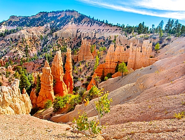
Hoodoos at Bryce Point, Bryce Canyon National Park, Utah, United States of America
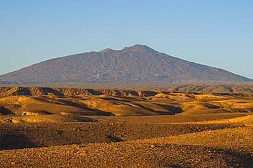
Tousside volcano above Trou du Natron, Tibesti Mountains, Chad
Aerial of the rocky mountains around Zouar, Tibesti Mountains, Chad
Aerial of beautiful rock formations around Zouar, Tibesti Mountains, Chad
Aerial of beautiful rock formations around Zouar, Tibesti Mountains, Chad
Aerial of Abeche, Chad
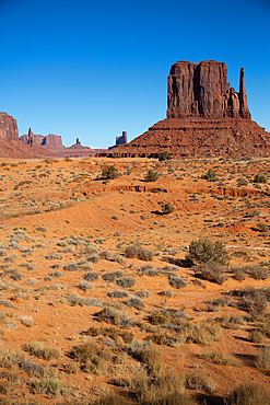
West Mitten Butte, Monument Valley Navajo Tribal Park, Utah, United States of America
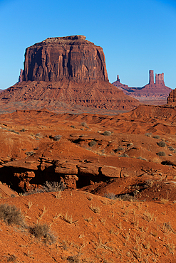
Merrick Butte, Monument Valley Navajo Tribal Park, Utah, United States of America
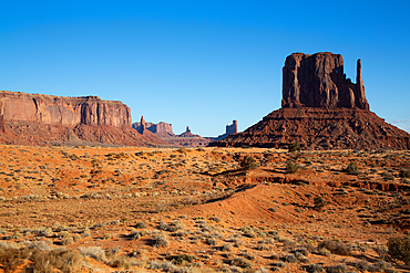
West Mitten Butte, Monument Valley Navajo Tribal Park, Utah, United States of America
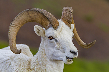
Adult Dall sheep (Ovis dalli) in Denali National Park, Alaska, United States of America

The dramatic scenery in the volcanic highlands of northern Saint Anthony, Cape Verde
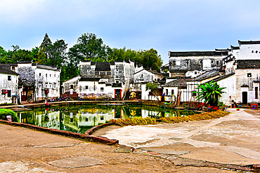
Central Bell Pond, with the land and pond in Yin Yang formation at Zhuge Bagua village, Lanxi County, Jinhua, Zhejiang Province, China
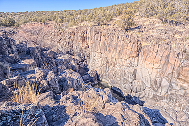
Dry waterfall cliffs, Johnson Canyon between Bainbridge Steel and Stone Dams near Ash Fork, Kaibab National Forest, Arizona, United States of America
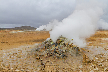
A view of the boiling mud at Namafjall, Iceland
Drone aerial view of Kriaritsi project area with abandoned roads in the south of Greece, Sithonia, Chalkidiki, Greece

Volcanic scenery in the valley of Alto Mira, northwest Saint Anthony, Cape Verde

Aerial of the Taiga around Tura, Krasnoyarsk Krai, Evenki state, Russia
Close to entrance to Jenny's Canyon, Snow Canyon State Park, near St. George, Utah, United States of America
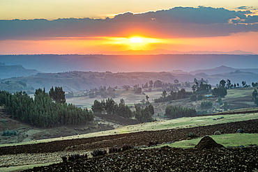
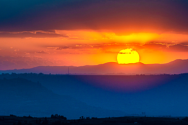
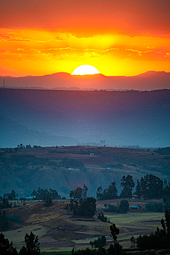
The sun setting over the mountains and valleys of Debre Berhan, Ethiopia.
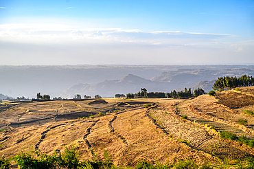
The rolling hillsides of Debre Berhan, Ethiopia.
Fields for farming purposes near Debre Berhan, Ethiopia
The rolling hillsides of Debre Berhan, Ethiopia.
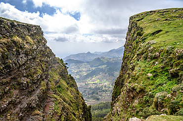
A ravine outside of Debre Berhan, Ethiopia.
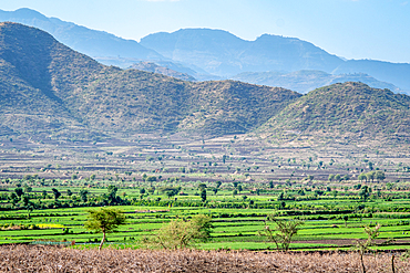
Fields laying below the mountains near Debre Berhan, Ethiopia
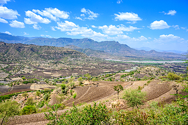
A view down into the beautiful and fertile valleys near Debre Berhan, Ethiopia.
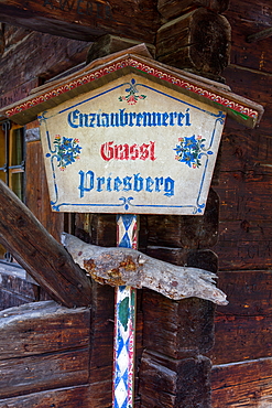
Enzianstechen at the Priesberghütte, Berchtesgadener Land, Upper Bavaria, Bavaria, Germany
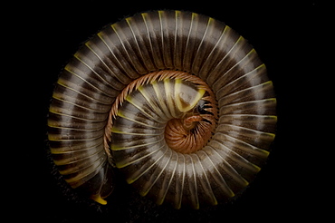
The Florida Ivory millipede (Spirobolida: Spirobolidae) a class of arthropod is thought to be among the first animals to have colonized land during the Silurian geologic period. The millipede's most obvious feature is its large number of legs. contrary to the Latin derivative of their name (thousand foot) the common species have between 80 and 400 legs.

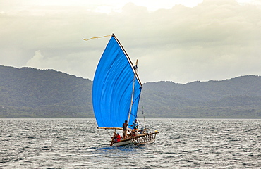
Nimoa Island - here the island mission will impress. The five-sided church features murals of island life and all mission buildings are surrounded by well maintained paths and gardens filled with flowering plants. Edged by jungle-covered mountains, postcard beaches and crystal clear waters - an island paradise indeed! The Louisiade Archipelago is a string of ten larger volcanic islands frequently fringed by coral reefs, and 90 smaller coral islands located 200 km southeast of New Guinea, stretching over more than 160 km and spread over an ocean area of 26,000 km? between the Solomon Sea to the north and the Coral Sea to the south. The aggregate land area of the islands is about 1,790 km? (690 square miles), with Vanatinai (formerly Sudest or Tagula as named by European claimants on Western maps) being the largest. Sideia Island and Basilaki Island lie closest to New Guinea, while Misima, Vanatinai, and Rossel islands lie further east. The archipelago is divided into the Local Level Government (LLG) areas Loui!

Nimoa Island - here the island mission will impress. The five-sided church features murals of island life and all mission buildings are surrounded by well maintained paths and gardens filled with flowering plants. Edged by jungle-covered mountains, postcard beaches and crystal clear waters - an island paradise indeed! The Louisiade Archipelago is a string of ten larger volcanic islands frequently fringed by coral reefs, and 90 smaller coral islands located 200 km southeast of New Guinea, stretching over more than 160 km and spread over an ocean area of 26,000 km? between the Solomon Sea to the north and the Coral Sea to the south. The aggregate land area of the islands is about 1,790 km? (690 square miles), with Vanatinai (formerly Sudest or Tagula as named by European claimants on Western maps) being the largest. Sideia Island and Basilaki Island lie closest to New Guinea, while Misima, Vanatinai, and Rossel islands lie further east. The archipelago is divided into the Local Level Government (LLG) areas Loui!

Nimoa Island - here the island mission will impress. The five-sided church features murals of island life and all mission buildings are surrounded by well maintained paths and gardens filled with flowering plants. Edged by jungle-covered mountains, postcard beaches and crystal clear waters - an island paradise indeed! The Louisiade Archipelago is a string of ten larger volcanic islands frequently fringed by coral reefs, and 90 smaller coral islands located 200 km southeast of New Guinea, stretching over more than 160 km and spread over an ocean area of 26,000 km? between the Solomon Sea to the north and the Coral Sea to the south. The aggregate land area of the islands is about 1,790 km? (690 square miles), with Vanatinai (formerly Sudest or Tagula as named by European claimants on Western maps) being the largest. Sideia Island and Basilaki Island lie closest to New Guinea, while Misima, Vanatinai, and Rossel islands lie further east. The archipelago is divided into the Local Level Government (LLG) areas Louisiade Rural (western part, with Misima), and Yaleyamba (western part, with Rossell and Tagula islands. The LLG areas are part of Samarai-Murua District district of Milne Bay. The seat of the Louisiade Rural LLG is Bwagaoia on Misima Island, the population center of the archipelago.
Nimoa Island - here the island mission will impress. The five-sided church features murals of island life and all mission buildings are surrounded by well maintained paths and gardens filled with flowering plants. Edged by jungle-covered mountains, postcard beaches and crystal clear waters - an island paradise indeed! The Louisiade Archipelago is a string of ten larger volcanic islands frequently fringed by coral reefs, and 90 smaller coral islands located 200 km southeast of New Guinea, stretching over more than 160 km and spread over an ocean area of 26,000 km? between the Solomon Sea to the north and the Coral Sea to the south. The aggregate land area of the islands is about 1,790 km? (690 square miles), with Vanatinai (formerly Sudest or Tagula as named by European claimants on Western maps) being the largest. Sideia Island and Basilaki Island lie closest to New Guinea, while Misima, Vanatinai, and Rossel islands lie further east.

Nimoa Island - here the island mission will impress. The five-sided church features murals of island life and all mission buildings are surrounded by well maintained paths and gardens filled with flowering plants. Edged by jungle-covered mountains, postcard beaches and crystal clear waters - an island paradise indeed! The Louisiade Archipelago is a string of ten larger volcanic islands frequently fringed by coral reefs, and 90 smaller coral islands located 200 km southeast of New Guinea, stretching over more than 160 km and spread over an ocean area of 26,000 km? between the Solomon Sea to the north and the Coral Sea to the south. The aggregate land area of the islands is about 1,790 km? (690 square miles), with Vanatinai (formerly Sudest or Tagula as named by European claimants on Western maps) being the largest. Sideia Island and Basilaki Island lie closest to New Guinea, while Misima, Vanatinai, and Rossel islands lie further east. The archipelago is divided into the Local Level Government (LLG) areas Louisiade Rural (western part, with Misima), and Yaleyamba (western part, with Rossell and Tagula islands. The LLG areas are part of Samarai-Murua District district of Milne Bay. The seat of the Louisiade Rural LLG is Bwagaoia on Misima Island, the population center of the archipelago.

Nimoa Island - here the island mission will impress. The five-sided church features murals of island life and all mission buildings are surrounded by well maintained paths and gardens filled with flowering plants. Edged by jungle-covered mountains, postcard beaches and crystal clear waters - an island paradise indeed! The Louisiade Archipelago is a string of ten larger volcanic islands frequently fringed by coral reefs, and 90 smaller coral islands located 200 km southeast of New Guinea, stretching over more than 160 km and spread over an ocean area of 26,000 km? between the Solomon Sea to the north and the Coral Sea to the south. The aggregate land area of the islands is about 1,790 km? (690 square miles), with Vanatinai (formerly Sudest or Tagula as named by European claimants on Western maps) being the largest. Sideia Island and Basilaki Island lie closest to New Guinea, while Misima, Vanatinai, and Rossel islands lie further east. The archipelago is divided into the Local Level Government (LLG) areas Louisiade Rural (western part, with Misima), and Yaleyamba (western part, with Rossell and Tagula islands. The LLG areas are part of Samarai-Murua District district of Milne Bay. The seat of the Louisiade Rural LLG is Bwagaoia on Misima Island, the population center of the archipelago.

Nimoa Island - here the island mission will impress. The five-sided church features murals of island life and all mission buildings are surrounded by well maintained paths and gardens filled with flowering plants. Edged by jungle-covered mountains, postcard beaches and crystal clear waters - an island paradise indeed! The Louisiade Archipelago is a string of ten larger volcanic islands frequently fringed by coral reefs, and 90 smaller coral islands located 200 km southeast of New Guinea, stretching over more than 160 km and spread over an ocean area of 26,000 km? between the Solomon Sea to the north and the Coral Sea to the south. The aggregate land area of the islands is about 1,790 km? (690 square miles), with Vanatinai (formerly Sudest or Tagula as named by European claimants on Western maps) being the largest. Sideia Island and Basilaki Island lie closest to New Guinea, while Misima, Vanatinai, and Rossel islands lie further east. The archipelago is divided into the Local Level Government (LLG) areas Loui!
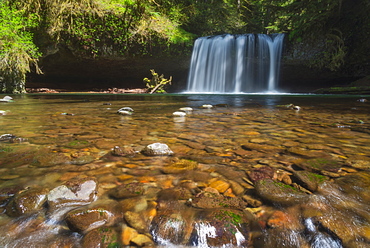
View of Butte Creek Falls, USA, Oregon, Marion County, Butte Creek Falls
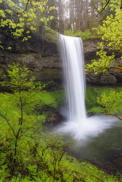
Waterfall in forest, USA, Oregon, Silver Falls State Park
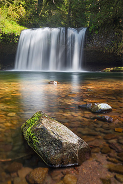
View of Butte Creek Falls, USA, Oregon, Marion County, Butte Creek Falls
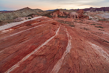
Rock formations at Valley of Fire State Park, USA, Nevada, Valley of Fire State Park
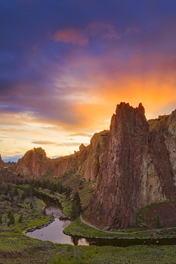
View of rock formation at sunset, USA, Oregon, Smith Rock State Park
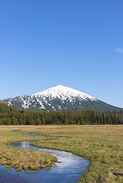
View of snowcapped Mount Bachelor, USA, Oregon, Mount Bachelor
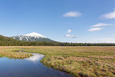
View of snowcapped Mount Bachelor, USA, Oregon, Mount Bachelor
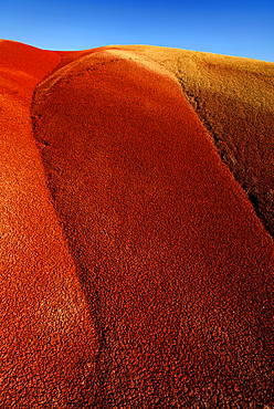
Painted Hills on sunny day, Painted Hills. Mitchell, Oregon