Results
8 results found
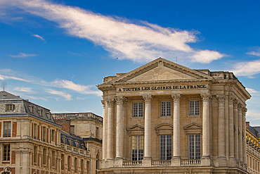
The image features a neoclassical building with columns and a pediment, part of a larger complex under a blue sky with clouds at Versailles Gardens, Paris.
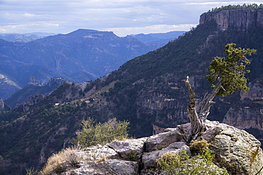
Divisadero, Copper Canyon, larger and deeper than the Grand Canyon, Mexico, North America
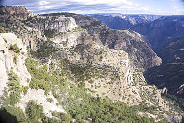
Copper Canyon, larger and deeper than the Grand Canyon, Mexico, North America
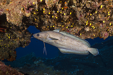
Larger Forkbeard at Teti Wreck, Phycis phycis, Vis Island, Mediterranean Sea, Croatia

Boating port with larger sailboats in Tenerife, Canary Islands, Spain, Atlantic, Europe

View of boats in harbour, restaurants from Ovo Castle, Naples, Campania, Italy, Europe
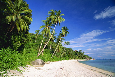
Tropical beach and palm trees on Perhentian Besar, larger of two Perhentian Islands with marine parks off the coast of Terengganu, Malaysia, Southeast Asia, Asia
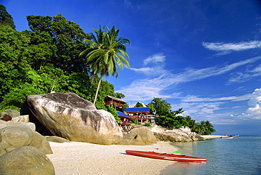
Houses and kayak on tropical beach on Perhentian Besar, larger of two Perhentian Islands with marine parks off the coast of Terengganu, Malaysia, Southeast Asia, Asia
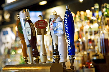
Beer taps in Georgetown bar, Washington DC, USA
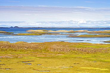
View of the islands along the southern edge of Hvammsfjordur which forms part of the larger Breidafjordur fjord, west area, Iceland, Polar Regions
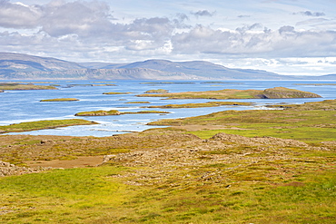
View of the islands along the southern edge of Hvammsfjordur which forms part of the larger Breidafjordur fjord, west area, Iceland, Polar Regions
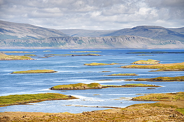
View of the islands along the southern edge of Hvammsfjordur which forms part of the larger Breidafjordur fjord, west area, Iceland, Polar Regions
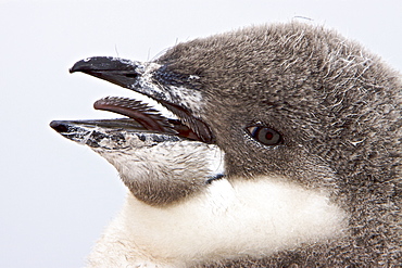
Chinstrap penguin (Pygoscelis antarctica) chick head detail at colony on Useful Island near the Antarctic Peninsula. There are an estimated 2 million breeding pairs of chinstrap penguins in the Antarctic peninsula region alone, perhaps as many as 7.5 million breeding pairs in all of Antarctica. Their name derives from the narrow black band under their heads which makes it appear as if they are wearing black helmets, making them one of the most easily identified types of penguin. Other names for them are "Ringed Penguins", "Bearded Penguins", and "Stonecracker Penguins" due to their harsh call. They grow to 68 cm (27 in). The average adult weight of a Chinstrap Penguin is 4.5 kg (10 lbs). Weight can range from 3 to 6 kg (6.6-13.2 lbs), with males being slightly larger and weight varying based on where the penguin is in the breeding cycle. Their diet consists of krill, shrimp, and fish. On land they build circular nests from stones, and lay two eggs, which are incubated by both the male and the female for shifts of five to ten days. They can also breed on icebergs, though they prefer non-icy conditions. The chicks hatch after about 35 days, and have fluffy gray backs and white fronts. The chicks stay in the nest for 20?30 days before they go to join a creche. At around 50?60 days old, they moult, gaining their adult plumage and go to sea. The Chinstrap Penguin was first described by German naturalist Forster in 1781. Its specific epithet was often seen as antarctica, however a 2002 review determined the genus Pygoscelis was masculine, and hence the correct binomial name is Pygoscelis antarcticus.
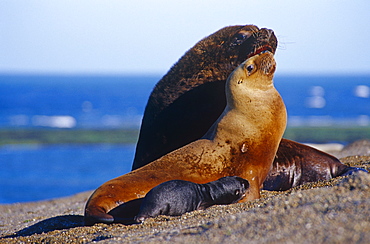
South American Sealion (Otaria flavescens) female and larger male. Punta Norte, Peninsula Valdez, Patagonia, Argentina.
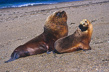
South American Sealion (Otaria flavescens) female and larger male. Punta Norte, Peninsula Valdez, Patagonia, Argentina.
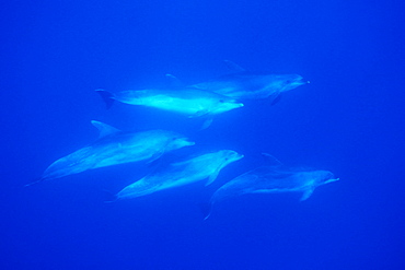
Bottlenose Dolphin (Tursiops truncatus), Oceanic larger sub-species. Azores, Portugal, Atlantic. (rr)
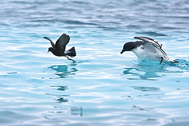
Adult Wilson's storm petrel (Oceanites oceanicus) feeding near a larger cape petrel after an iceberg calved near Port Lockroy, near the Antarctic Peninsula
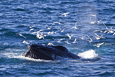
Adult humpback whale (Megaptera novaeangliae) sub-surface feeding among black-legged kittiwakes (Rissa tridactyla) off the continental shelf west of Spitsbergen in the Barents Sea, Norway. Humpbacks are one of the larger rorqual species, adults range in length from 12?16 metres (40?50 ft) and weigh approximately 36,000 kilograms (79,000 lb). There are at least 80,000 humpback whales worldwide.
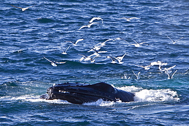
Adult humpback whale (Megaptera novaeangliae) sub-surface feeding among black-legged kittiwakes (Rissa tridactyla) off the continental shelf west of Spitsbergen in the Barents Sea, Norway. Humpbacks are one of the larger rorqual species, adults range in length from 12?16 metres (40?50 ft) and weigh approximately 36,000 kilograms (79,000 lb). There are at least 80,000 humpback whales worldwide.

Adult humpback whale (Megaptera novaeangliae) sub-surface feeding among black-legged kittiwakes (Rissa tridactyla) off the continental shelf west of Spitsbergen in the Barents Sea, Norway. Humpbacks are one of the larger rorqual species, adults range in length from 12?16 metres (40?50 ft) and weigh approximately 36,000 kilograms (79,000 lb). There are at least 80,000 humpback whales worldwide.

Aerial view of a larger group of seals hauled out on the sand and in the water. Gulf of Maine, USA (rr)
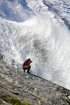
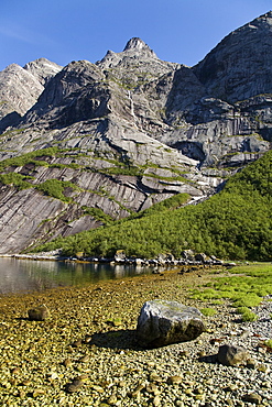
A photographer at a snow melt waterfall in Nordfjord, an arm of the larger Melfjord - situated just above the Arctic Circle - in northern Norway, Barents Sea.

A photographer at a snow melt waterfall in Nordfjord, an arm of the larger Melfjord - situated just above the Arctic Circle - in northern Norway, Barents Sea.

A photographer at a snow melt waterfall in Nordfjord, an arm of the larger Melfjord - situated just above the Arctic Circle - in northern Norway, Barents Sea.
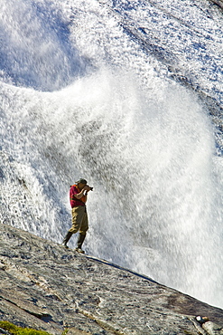
A photographer at a snow melt waterfall in Nordfjord, an arm of the larger Melfjord - situated just above the Arctic Circle - in northern Norway, Barents Sea.
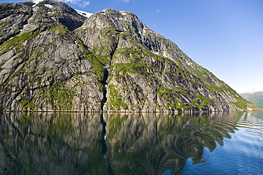
A view of Nordfjord, an arm of the larger Melfjord - situated just above the Arctic Circle - in northern Norway, Barents Sea.
A view of Nordfjord, an arm of the larger Melfjord - situated just above the Arctic Circle - in northern Norway, Barents Sea.
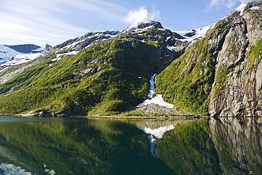
A view of Nordfjord, an arm of the larger Melfjord - situated just above the Arctic Circle - in northern Norway, Barents Sea.
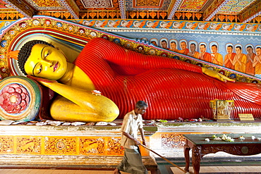
Larger than life sized Buddha statue inside the Isurumunjya temple, Isurumuni Maha Vihara, Sacred City, Anuradhapura, Sri Lanka, Asia
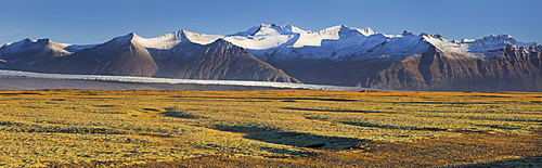
Breidamerkurjokull, outlet glacier of the larger glacier of Vatnajokull, Prestfell, Midfellstindur, Sudursveit, East Iceland, Iceland
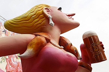
Snooty-nosed woman, caricature in front of a beer tent, Rhine funfair, Duesseldorf, NRW, Germany
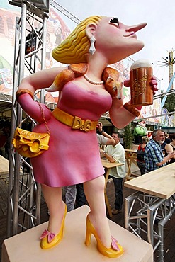
Snooty-nosed woman, caricature in front of a beer tent, Rhine funfair, Duesseldorf, NRW, Germany

Ead of a fantasy figure with bandaged nose and tongue hanging out, caricature made of paper mache , monday before lent parade, Duesseldorf, NRW, Germany
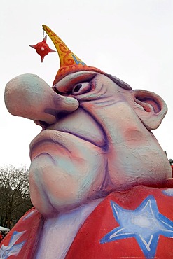
Face of a man with huge nose and mad eyes, caricature made of paper mache, monday before lent parade, Duesseldorf, NRW, Germany
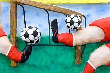
Two footballers are shooting simultaneously two balls, caricature made of paper mache , monday before lent parade, Duesseldorf, NRW, Germany
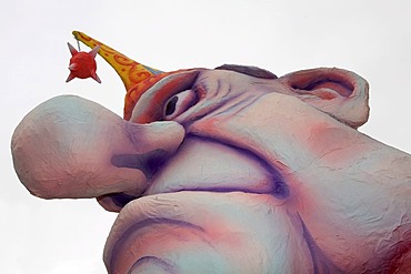
Face of a man with huge nose and mad eyes, caricature made of paper mache, monday before lent parade, Duesseldorf, NRW, Germany
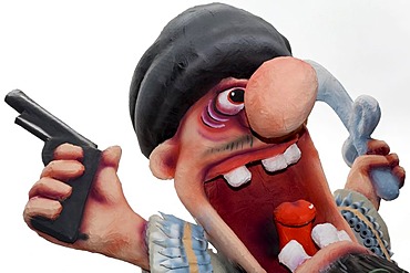
Provocative figure of a mullah appearing as combattant with sabre and pistol, caricature made of paper mache, monday before lent parade, Duesseldorf, NRW, Germany
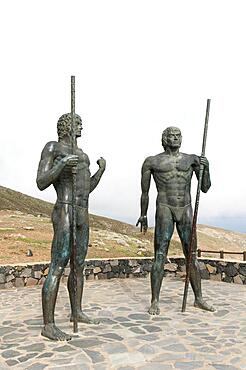
Guanches, ancient Canarians, larger-than-life bronze warrior statues guard the valley Vega de Rio de las Palmas, on the road to Betancuria, Fuerteventura, Canary Islands, Spain, Europe
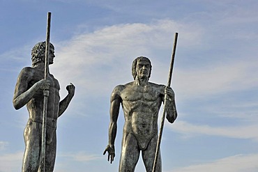
Larger-than-life-sized bronze warrior figures guarding the valley of Vega de Rio de las Palmas beside the road after Betancuria, Fuerteventura, Canary islands, Spain, Europe
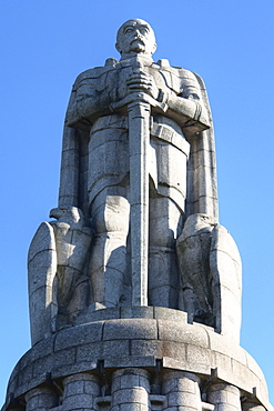
Bismarck-Denkmal (Bismarck monument), St. Pauli, Hamburg, Germany
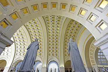
Interior view, Great Main Hall, larger than life statues, waiting room, Union Station, Washington DC, District of Columbia, United States of America

Elderly man in a dugout canoe beside a large fishing boat. Sulima is a fishing village on the Alantic coast at the mouth of the Moa River near the Liberian border. Along its pristine beach, one of the longest in West Africa, fishermen launch dugout canoes and fish with nets drag back manually from the shore. Larger power boats mainly from Ghana leave from the more sheltered harbour on the Moa River. Most of the fish is smoke dried by the women of the village and then sold in markets as far off as Monrovia, Liberia.
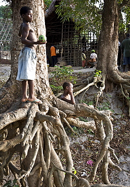
Young boys looking out over the town's port. Sulima is a fishing village on the Alantic coast at the mouth of the Moa River near the Liberian border. Along its pristine beach, one of the longest in West Africa, fishermen launch dugout canoes and fish with nets drag back manually from the shore. Larger power boats mainly from Ghana leave from the more sheltered harbour on the Moa River. Most of the fish is smoke dried by the women of the village and then sold in markets as far off as Monrovia, Liberia.

A guard at Queen Gawhar Shad's mausoleum, stands in front of four tall minarets, once part of a madrassa that was built in the 15th century by the last of the Timurid rulers, in Herat, Herat Province, Afghanistan. One of the finest examples of Timurid architecture, the minarets are spectacular remnants of a much larger complex considered to be one of the finest examples of Timurid architecture
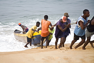
Group of young men pulling a fishing boat out of the ocean. Sulima is a fishing village on the Alantic coast at the mouth of the Moa River near the Liberian border. Along its pristine beach, one of the longest in West Africa, fishermen launch dugout canoes and fish with nets drag back manually from the shore. Larger power boats mainly from Ghana leave from the more sheltered harbour on the Moa River. Most of the fish is smoke dried by the women of the village and then sold in markets as far off as Monrovia, Liberia.
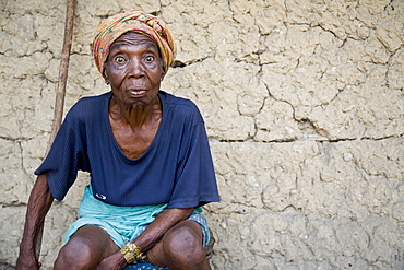
Elderly woman making a funny face. Sulima is a fishing village on the Alantic coast at the mouth of the Moa River near the Liberian border. Along its pristine beach, one of the longest in West Africa, fishermen launch dugout canoes and fish with nets drag back manually from the shore. Larger power boats mainly from Ghana leave from the more sheltered harbour on the Moa River. Most of the fish is smoke dried by the women of the village and then sold in markets as far off as Monrovia, Liberia.
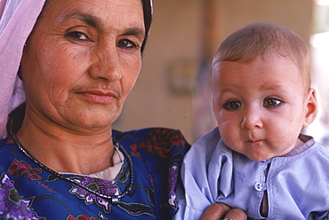
A Tajik woman holds a baby with kohl rimmed eyes, in the compound of an extended, traditional family in Mazar-i-Sharif, Balkh Province, September 25, 2002. The Tajik are one of the larger ethnic groups in Afghanistan, second only to the Pashtun people.
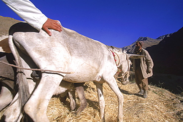
Tajik farmers and their families thresh wheat with oxen and donkeys, in a side valley to the Panjshir Valley, in the Hindu Kush mountains, September 10, 2002. Agriculture is primitive and labor intensive in this remote valley. The Panjshir Valley and its side valleys have long been a stronghold for the Tajik people, and the famous commander Ahmed Shah Masood, in their struggle first against the Soviets and then against the Taliban. The Tajik are one of the larger ethnic groups in Afghanistan, second only to the Pashtun people.
The Louisiade Archipelago is a string of ten larger volcanic islands frequently fringed by coral reefs, and 90 smaller coral islands located 200 km southeast of New Guinea, stretching over more than 160 km and spread over an ocean area of 26,000 km? between the Solomon Sea to the north and the Coral Sea to the south. The aggregate land area of the islands is about 1,790 km? (690 square miles), with Vanatinai (formerly Sudest or Tagula as named by European claimants on Western maps) being the largest.Sideia Island and Basilaki Island lie closest to New Guinea, while Misima, Vanatinai, and Rossel islands lie further east. The archipelago is divided into the Local Level Government (LLG) areas Louisiade Rural (western part, with Misima), and Yaleyamba (western part, with Rossell and Tagula islands. The LLG areas are part of Samarai-Murua District district of Milne Bay. The seat of the Louisiade Rural LLG is Bwagaoia on Misima Island, the population center of the archipelago.
The Louisiade Archipelago is a string of ten larger volcanic islands frequently fringed by coral reefs, and 90 smaller coral islands located 200 km southeast of New Guinea, stretching over more than 160 km and spread over an ocean area of 26,000 km? between the Solomon Sea to the north and the Coral Sea to the south. The aggregate land area of the islands is about 1,790 km? (690 square miles), with Vanatinai (formerly Sudest or Tagula as named by European claimants on Western maps) being the largest. Sideia Island and Basilaki Island lie closest to New Guinea, while Misima, Vanatinai, and Rossel islands lie further east. The archipelago is divided into the Local Level Government (LLG) areas Louisiade Rural (western part, with Misima), and Yaleyamba (western part, with Rossell and Tagula islands. The LLG areas are part of Samarai-Murua District district of Milne Bay. The seat of the Louisiade Rural LLG is Bwagaoia on Misima Island, the population center of the archipelago.

Nimoa Island - here the island mission will impress. The five-sided church features murals of island life and all mission buildings are surrounded by well maintained paths and gardens filled with flowering plants. Edged by jungle-covered mountains, postcard beaches and crystal clear waters - an island paradise indeed! The Louisiade Archipelago is a string of ten larger volcanic islands frequently fringed by coral reefs, and 90 smaller coral islands located 200 km southeast of New Guinea, stretching over more than 160 km and spread over an ocean area of 26,000 km? between the Solomon Sea to the north and the Coral Sea to the south. The aggregate land area of the islands is about 1,790 km? (690 square miles), with Vanatinai (formerly Sudest or Tagula as named by European claimants on Western maps) being the largest. Sideia Island and Basilaki Island lie closest to New Guinea, while Misima, Vanatinai, and Rossel islands lie further east. The archipelago is divided into the Local Level Government (LLG) areas Loui!

Nimoa Island - here the island mission will impress. The five-sided church features murals of island life and all mission buildings are surrounded by well maintained paths and gardens filled with flowering plants. Edged by jungle-covered mountains, postcard beaches and crystal clear waters - an island paradise indeed! The Louisiade Archipelago is a string of ten larger volcanic islands frequently fringed by coral reefs, and 90 smaller coral islands located 200 km southeast of New Guinea, stretching over more than 160 km and spread over an ocean area of 26,000 km? between the Solomon Sea to the north and the Coral Sea to the south. The aggregate land area of the islands is about 1,790 km? (690 square miles), with Vanatinai (formerly Sudest or Tagula as named by European claimants on Western maps) being the largest. Sideia Island and Basilaki Island lie closest to New Guinea, while Misima, Vanatinai, and Rossel islands lie further east. The archipelago is divided into the Local Level Government (LLG) areas Loui!

Nimoa Island - here the island mission will impress. The five-sided church features murals of island life and all mission buildings are surrounded by well maintained paths and gardens filled with flowering plants. Edged by jungle-covered mountains, postcard beaches and crystal clear waters - an island paradise indeed! The Louisiade Archipelago is a string of ten larger volcanic islands frequently fringed by coral reefs, and 90 smaller coral islands located 200 km southeast of New Guinea, stretching over more than 160 km and spread over an ocean area of 26,000 km? between the Solomon Sea to the north and the Coral Sea to the south. The aggregate land area of the islands is about 1,790 km? (690 square miles), with Vanatinai (formerly Sudest or Tagula as named by European claimants on Western maps) being the largest. Sideia Island and Basilaki Island lie closest to New Guinea, while Misima, Vanatinai, and Rossel islands lie further east. The archipelago is divided into the Local Level Government (LLG) areas Louisiade Rural (western part, with Misima), and Yaleyamba (western part, with Rossell and Tagula islands. The LLG areas are part of Samarai-Murua District district of Milne Bay. The seat of the Louisiade Rural LLG is Bwagaoia on Misima Island, the population center of the archipelago.
Nimoa Island - here the island mission will impress. The five-sided church features murals of island life and all mission buildings are surrounded by well maintained paths and gardens filled with flowering plants. Edged by jungle-covered mountains, postcard beaches and crystal clear waters - an island paradise indeed! The Louisiade Archipelago is a string of ten larger volcanic islands frequently fringed by coral reefs, and 90 smaller coral islands located 200 km southeast of New Guinea, stretching over more than 160 km and spread over an ocean area of 26,000 km? between the Solomon Sea to the north and the Coral Sea to the south. The aggregate land area of the islands is about 1,790 km? (690 square miles), with Vanatinai (formerly Sudest or Tagula as named by European claimants on Western maps) being the largest. Sideia Island and Basilaki Island lie closest to New Guinea, while Misima, Vanatinai, and Rossel islands lie further east.
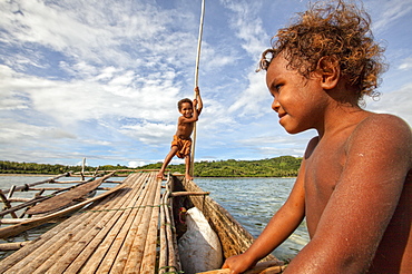
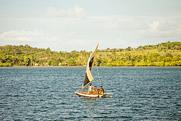
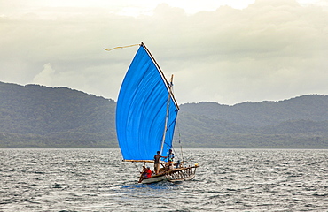
Children playing with a outrigger canoe in the village of Hessessai Bay at PanaTinai (Panatinane)island in the Louisiade Archipelago in Milne Bay Province, Papua New Guinea. The island has an area of 78 km2. The Louisiade Archipelago is a string of ten larger volcanic islands frequently fringed by coral reefs, and 90 smaller coral islands located 200 km southeast of New Guinea, stretching over more than 160 km and spread over an ocean area of 26,000 km? between the Solomon Sea to the north and the Coral Sea to the south. The aggregate land area of the islands is about 1,790 km? (690 square miles), with Vanatinai (formerly Sudest or Tagula as named by European claimants on Western maps) being the largest. Sideia Island and Basilaki Island lie closest to New Guinea, while Misima, Vanatinai, and Rossel islands lie further east. The archipelago is divided into the Local Level Government (LLG) areas Louisiade Rural (western part, with Misima), and Yaleyamba (western part, with Rossell and Tagula islands. The LLG areas are part of Samarai-Murua District district of Milne Bay. The seat of the Louisiade Rural LLG is Bwagaoia on Misima Island, the population center of the archipelago.PanaTinai (Panatinane) is an island in the Louisiade Archipelago in Milne Bay Province, Papua New Guinea.

Nimoa Island - here the island mission will impress. The five-sided church features murals of island life and all mission buildings are surrounded by well maintained paths and gardens filled with flowering plants. Edged by jungle-covered mountains, postcard beaches and crystal clear waters - an island paradise indeed! The Louisiade Archipelago is a string of ten larger volcanic islands frequently fringed by coral reefs, and 90 smaller coral islands located 200 km southeast of New Guinea, stretching over more than 160 km and spread over an ocean area of 26,000 km? between the Solomon Sea to the north and the Coral Sea to the south. The aggregate land area of the islands is about 1,790 km? (690 square miles), with Vanatinai (formerly Sudest or Tagula as named by European claimants on Western maps) being the largest. Sideia Island and Basilaki Island lie closest to New Guinea, while Misima, Vanatinai, and Rossel islands lie further east. The archipelago is divided into the Local Level Government (LLG) areas Louisiade Rural (western part, with Misima), and Yaleyamba (western part, with Rossell and Tagula islands. The LLG areas are part of Samarai-Murua District district of Milne Bay. The seat of the Louisiade Rural LLG is Bwagaoia on Misima Island, the population center of the archipelago.

Nimoa Island - here the island mission will impress. The five-sided church features murals of island life and all mission buildings are surrounded by well maintained paths and gardens filled with flowering plants. Edged by jungle-covered mountains, postcard beaches and crystal clear waters - an island paradise indeed! The Louisiade Archipelago is a string of ten larger volcanic islands frequently fringed by coral reefs, and 90 smaller coral islands located 200 km southeast of New Guinea, stretching over more than 160 km and spread over an ocean area of 26,000 km? between the Solomon Sea to the north and the Coral Sea to the south. The aggregate land area of the islands is about 1,790 km? (690 square miles), with Vanatinai (formerly Sudest or Tagula as named by European claimants on Western maps) being the largest. Sideia Island and Basilaki Island lie closest to New Guinea, while Misima, Vanatinai, and Rossel islands lie further east. The archipelago is divided into the Local Level Government (LLG) areas Louisiade Rural (western part, with Misima), and Yaleyamba (western part, with Rossell and Tagula islands. The LLG areas are part of Samarai-Murua District district of Milne Bay. The seat of the Louisiade Rural LLG is Bwagaoia on Misima Island, the population center of the archipelago.

Nimoa Island - here the island mission will impress. The five-sided church features murals of island life and all mission buildings are surrounded by well maintained paths and gardens filled with flowering plants. Edged by jungle-covered mountains, postcard beaches and crystal clear waters - an island paradise indeed! The Louisiade Archipelago is a string of ten larger volcanic islands frequently fringed by coral reefs, and 90 smaller coral islands located 200 km southeast of New Guinea, stretching over more than 160 km and spread over an ocean area of 26,000 km? between the Solomon Sea to the north and the Coral Sea to the south. The aggregate land area of the islands is about 1,790 km? (690 square miles), with Vanatinai (formerly Sudest or Tagula as named by European claimants on Western maps) being the largest. Sideia Island and Basilaki Island lie closest to New Guinea, while Misima, Vanatinai, and Rossel islands lie further east. The archipelago is divided into the Local Level Government (LLG) areas Loui!

Full Moon Over Halemaumau Crater Within The Much Larger Summit Caldera Of Kilauea In Hawaii Volcanoes National Park, Steaming Vents In Foreground, Mauna Loa Mountain In Background, Island Of Hawaii, Hawaii, United States Of America

orang utan Sumatran orang utan orang utan couple small female and larger male sitting on foilage lying on rocks holding each other with arms and legs male pouting lips