Results
80 results found
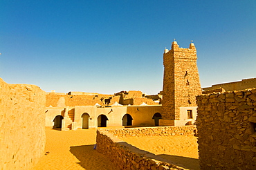
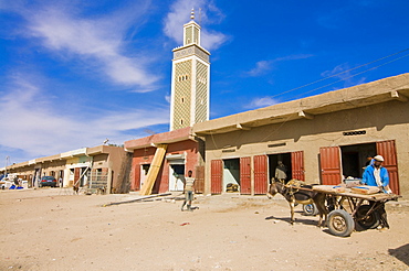
The Great Friday Mosque, UNESCO World Heritage Site, Chinguetti, medieval trading centre in northern Mauritania, Africa

Colourful fishing boats at the fishing habour, Nouakchott, Mauritania, Africa
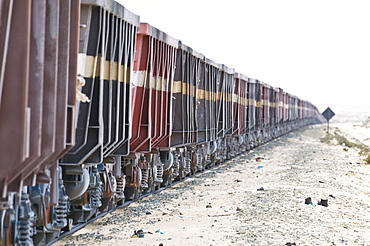
The longest iron ore train in the world between Zouerate and Nouadhibou, Mauritania, Africa
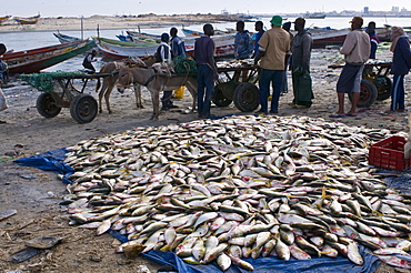
Fish for sale laid out on the ground at the fish market, Nouadhibou, Mauritania, Africa
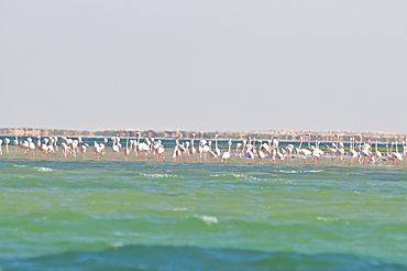
Flamingos (Phoenicopteridae) standing on a sandbank of the Banc d'Arguin, UNESCO World Heritage Site, Mauritania, Africa

Sand dunes at sunset, near Chinguetti, Mauritania, Africa
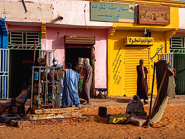
Market in front of the Moroccon Mosque, Nouakchott, Mauritania, Africa

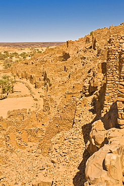
The ruined old caravan center of Ouadane, UNESCO World Heritage Site, Mauritania, Africa
Little oasis between sand dunes at sunset, near Chinguetti, Mauritania, Africa
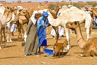
Men trading camels at the camel market of Nouakchott, Mauritania, Africa
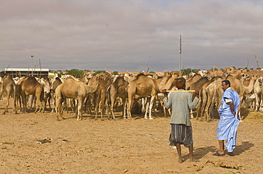
Men trading camels at the camel market, Nouakchott, Mauritania, Africa

Traditional sailing boats in the Banc d'Arguin, Mauritania, Africa

Traditional sailing boat in waters of the Banc d'Arguin, Mauritania, Africa

Stranded vessel at a beach of Cap Blanc, Nouadhibou, Mauritania, Africa
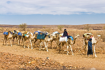
Camel caravan riding through the stone desert near Atar, Mauritania, Africa

Fishing boats in the habour of Nouadhibou, Mauritania, Africa
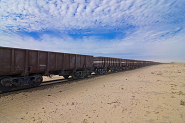
The longest iron ore train in the world between Zouerate and Nouadhibou, Mauritania, Africa

Sandy square at the UNESCO World Heritage Site of Chinguetti, medieval trading centre in northern Mauritania, Africa
The longest iron ore train in the world between Zouerate and Nouadhibou, Mauritania, Africa
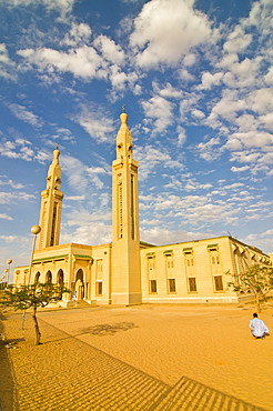
Central Mosque in Nouakchott, Mauritania, Africa

Stranded vessel at a beach of Cap Blanc, Nouadhibou, Mauritania, Africa

Nouakchott Camel Market, Nouakchott, Mauritania, West Africa, Africa

One of the many towns between Nouakchott and Tidjikdja, Mauritania, Sahara Desert, West Africa, Africa
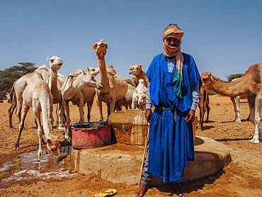
A worker with his dromedaries, taking water out of a well in a village between Nouakchott and Tidjikdja, Mauritania, Sahara, West Africa, Africa

A village near Kamour, Mauritania, Sahara Desert, West Africa, Africa
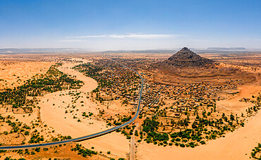
A crumbling mountain, a river bed, palms, and dunes surround the village of Kamour, Mauritania, Sahara Desert, West Africa, Africa

A group of peculiar rock formations between Kiffa and Ayoun, Mauritania, Sahara Desert, West Africa, Africa

Nouakchott Camel Market, Nouakchott, Mauritania, West Africa, Africa

Sheik Hamal Mosque in the old port town of Massawa, Eritrea, Africa
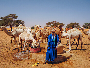
A worker with dromedaries, taking water out of a well in a village between Nouakchott and Tidjikdja, Mauritania, Sahara, West Africa, Africa

A series of rock formations between Kiffa and Ayoun, Mauritania, Sahara Desert, West Africa, Africa

Nouakchott Camel Market, Nouakchott, Mauritania, West Africa, Africa
A group of peculiar rock formations between Kiffa and Ayoun, Mauritania, Sahara Desert, West Africa, Africa

The central mosque of Nouakchott sponsored by Saudi Arabia, Nouakchott, Mauritania, Africa

A series of rock formations between Kiffa and Ayoun, Mauritania, Sahara Desert, West Africa, Africa

The streets and people of a village between Kiffa and Ayoun, Mauritania, Sahara Desert, West Africa, Africa

Desert between Moroccan border and Nouadhibou, Mauritania, Africa

Fish for sale laid out on the ground at the fish market, Nouadhibou, Mauritania, Africa
Locals in the streets of Boutilimit, Mauritania, Sahara Desert, West Africa, Africa

A group of peculiar rock formations between Kiffa and Ayoun, Mauritania, Sahara Desert, West Africa, Africa

Nouakchott Camel Market, Nouakchott, Mauritania, West Africa, Africa
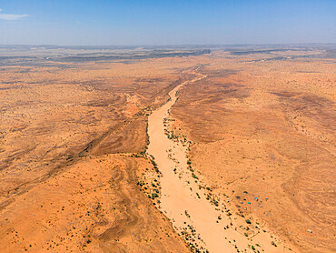
A river bed, palms, and dunes surround the village of Kamour, Mauritania, Sahara Desert, West Africa, Africa

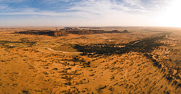
A huge rock cliff and canyon near Kamour, Mauritania, Sahara Desert, West Africa, Africa

A stretch of white dunes surrounded by canyons near Kamour, Mauritania, Sahara Desert, West Africa, Africa

Desert plant between Nouadhibou and Nouakchott, Mauritania, Africa

Livestock in Boutilimit, Mauritania, Sahara Desert, West Africa, Africa

A huge rock cliff and canyon near Kamour, Mauritania, Sahara Desert, West Africa, Africa

One of the many towns between Nouakchott and Tidjikdja, Mauritania, Sahara Desert, West Africa, Africa

The streets and people of a village between Kiffa and Ayoun, Mauritania, Sahara Desert, West Africa, Africa

The streets and people of a village between Kiffa and Ayoun, Mauritania, Sahara Desert, West Africa, Africa

A village near Kamour, Mauritania, Sahara Desert, West Africa, Africa

Men trading camels at the camel market of Nouakchott, Mauritania, Africa
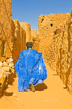
Man walking through the old town at the UNESCO World Heritage Site of Chinguetti, medieval trading centre in northern Mauritania, Africa

Nouakchott Camel Market, Nouakchott, Mauritania, West Africa, Africa

A huge rock cliff and canyon near Kamour, Mauritania, Sahara Desert, West Africa, Africa

Camels standing on the road between Nouadhibou and Nouakchott, Mauritania, Africa

The streets and people of a village between Kiffa and Ayoun, Mauritania, Sahara Desert, West Africa, Africa

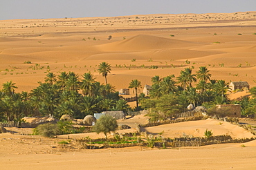
The Oasis of Diouk, Mauritania, Sahara Desert, West Africa, Africa

A series of rock formations between Kiffa and Ayoun, Mauritania, Sahara Desert, West Africa, Africa

A man carrying bread at the market of a village near Ayoun El Atrous, Hodh El Gharbi, Mauritania, Sahara Desert, West Africa, Africa

The Oasis of Diouk, Mauritania, Sahara Desert, West Africa, Africa

The Oasis of Diouk, Mauritania, Sahara Desert, West Africa, Africa

Nouakchott Camel Market, Nouakchott, Mauritania, West Africa, Africa

A group of peculiar rock formations between Kiffa and Ayoun, Mauritania, Sahara Desert, West Africa, Africa

Central mosque in Nouakchott, Mauritania, Africa

Sand dunes at sunset, near Chinguetti, Mauritania, Africa

Traditional sailing boat in the Banc d'Arguin, UNESCO World Heritage Site, Mauritania, Africa

A huge rock cliff and canyon near Kamour, Mauritania, Sahara Desert, West Africa, Africa
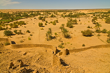
Ouadane, UNESCO World Heritage Site, Mauritania, Africa

Footsteps in sand dunes at sunset, near Chinguetti, Mauritania, Africa
Ouadane, UNESCO World Heritage Site, Mauritania, Africa

Portrait of man, Nouadhibou, Mauritania, Africa
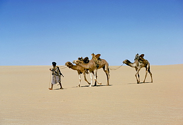
Part of escort to camel train in Empty quarter of Mauritania-Mali, Africa

Stranded vessels lying in the ship graveyard of Nouadhibou, Mauritania, Africa

Woman carrying firewood, Ouadane, Mauritania, Africa

Central bazaar of Nouakchott, Mauritania, Africa
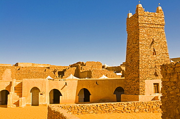
Ksar or medieval trading centre of Chinguetti, UNESCO World Heritage Site, Northern Mauritania, Africa

Children playing soccer at a sandy field, Nouadhibou, Mauritania, Africa
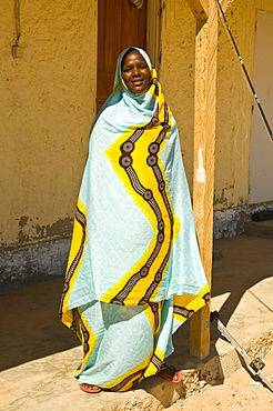
Traditionally dressed woman standing in the shade, Banc d´Arguin, Mauritania, Africa
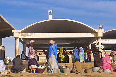
Local people trading at the fish market of Nouakchott, Mauritania, Africa

Baleen whale skull showing baleen plates, Nouamghar, Mauritania (RR)

Stranded Bottlenose dolphin (Tursiops truncatus) on beach, Mauritania (RR)

Dolphin bones on a beach, Mauritania
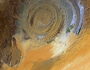
The Richat Structure, Mauritania, satellite image

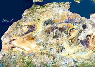
Satellite view of Africa. This image was compiled from data acquired by Landsat 7 & 8 satellites.
Sahara Desert, Africa, True Colour Satellite Image. Sahara desert, true colour satellite image. The Sahara is the world's largest hot desert, made of sand and volcanic mountains. Composite image using data from LANDSAT 5 & 7 satellites.
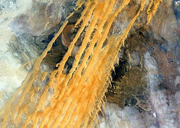
Desert Erg Iguidi, Algeria, True Colour Satellite Image. True colour satellite image of Erg Iguidi, a sand desert between Algeria and Mauritania. The 250m wide dunes lay in the South on a sand plain, and in the North on a blakek sandstone area. The light blue areas are calcareous and salt crusts left out from the evaporation of the oueds' water. Image taken on 29 March 1987 using LANDSAT data.

Satellite view of Senegal River that forms the border between Senegal and Mauritania in West Africa.This image was taken in 2014 by Landsat 8 satellite.
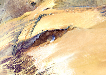
Richat Structure, Mauritania, True Colour Satellite Image. Richat Structure, Mauritania, true colour satellite image

Portrait of a Mauritanian man, Nouakchott, Mauritania, northwestern Africa

The ruins of Ouadane, UNESCO World Heritage Site, Mauritania, northwestern Africa
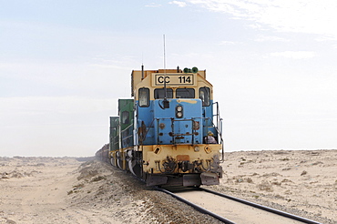
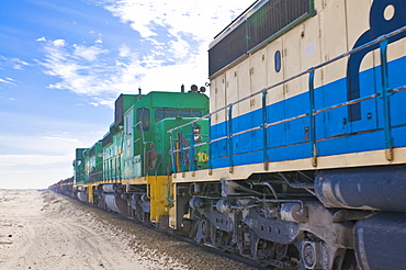
Iron ore train of Zouerat, the longest and heaviest train in the world, Nouadhibou, Mauritania, northwestern Africa
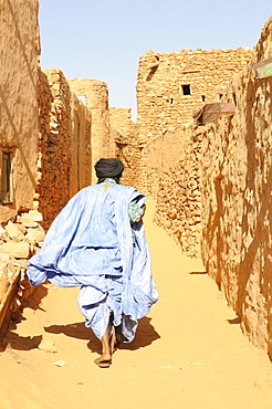
Man walking through the sandy lanes of the town of Chinguetti, Mauritania, northwestern Africa

Total fuel station in the Sahara desert, between Nouadhibou and Nouakchott, Mauritania, northwestern Africa

Old Renault travelling through the Sahara, Nouakchott, Mauritania, northwestern Africa
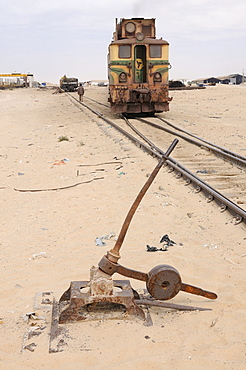
Track switch in front of the iron ore train of Zouerat, the longest and heaviest train in the world, Nouadhibou, Mauritania, northwestern Africa

Stranded cargo boat on the shore of Cap Blanc, Nouadhibou, Mauritania, northwestern Africa

Veiled women with traditional dress walking near Atar, Mauritania, northwestern Africa

Trading on the camel market of Nouakchott, Mauritania, northwestern Africa
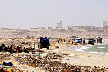
People collecting metal and other parts of rusting ships left over at the ship cemetery of Nouadhibou, Mauritania, Africa