Results
5 results found
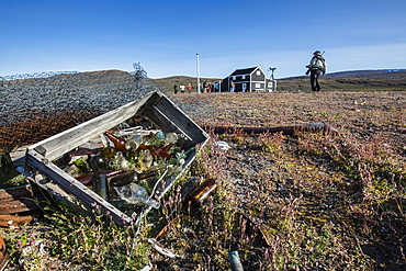
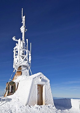
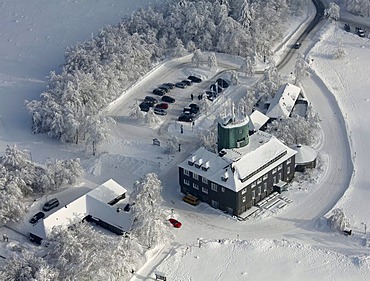
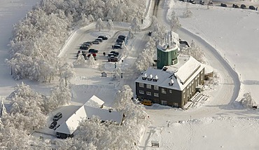
Radio and Meteorology station, Myggebukta (Mosquito Bay), Christian X's Land, Northeast Greenland, Polar Regions
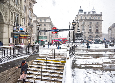
Underground Station entrance, snow storm, Piccadilly Circus, West End, London, England, United Kingdom, Europe
Radio and Meteorology station, Myggebukta (Mosquito Bay), Christian X's Land, Northeast Greenland, Polar Regions
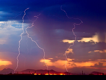
Three bolts of lightning striking near the Palo Verde Nuclear Station in Wintersburg Arizona during the 2012 Monsoon season, Arizona, United States of America, North America
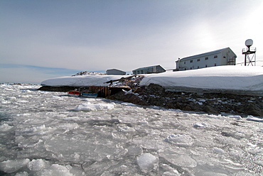
Ukrainian weather outpost, Vernadsky Station, Antarctica, Polar Regions
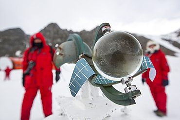
A Campbell Stokes Sunshine Recorder, which measures hours of sunlight at Base Orcadas, which is an Argentine scientific station in Antarctica, and the oldest of the stations in Antarctica still in operation. It is located on Laurie Island, one of the South Orkney Islands, just off the Antarctic Peninsular. The Antarctic Peninsular is one of the fastest warming places on the planet.

An automated weather station being powered by solar panels at Machapuchare Base Camp, Himalayas, Nepal, Asia

An automated weather station being powered by solar panels at Machapuchare Base Camp, Himalayas, Nepal, Asia
Vernadsky Research Base (Akademik Vernadsky), Ukrainian Antarctic Station at Marina Point on Galindez Island in the Argentine Islands, Antarctica

A weather station in the Daintree rainforest in the North of Queensland, Australia, Pacific
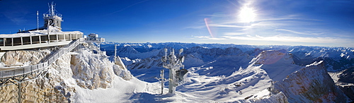
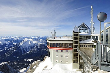
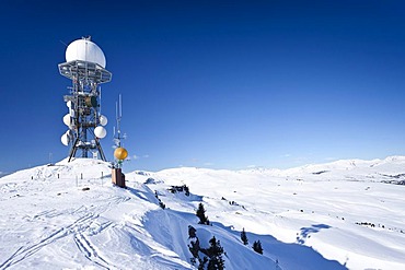
Zugspitze, Germany's highest mountain, the German weather station (DWD) and skiing area, on the border between Germany and Austria, Europe

Aerial photo, Winterberg, Kahler Asten with snow, Astenturm, weather station, Rothaargebirge, Hochsauerlandkreis, Sauerland, North Rhine-Westphalia, Germany, Europe
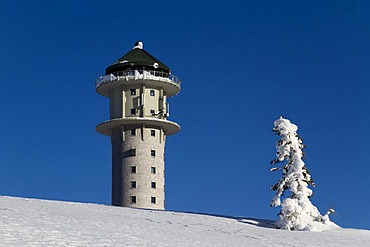
Frozen little weather station, Mt. Saentis, Switzerland, Europe
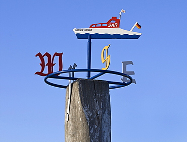
Wind rose of the Cassen Knigge, pier, SAR boat of the DGzRS German Maritime Rescue, Lifeboat Station Western Harbour, Norddeich district, Norden, Lower Saxony, Germany, Europe

Meteorological station on Rittnerhorn mountain above Ritten, Bolzano area, province of Bolzano-Bozen, Italy, Europe
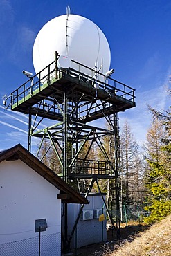
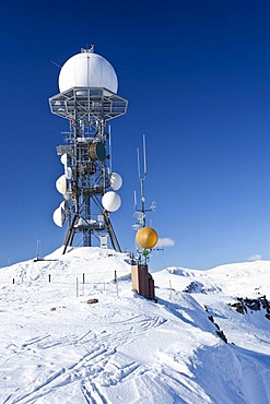
Precipitation Radar Station on Gantkofel Mountain, Mendel Ridge, Alto Adige, Italy, Europe

Antenna mast on the summit plateau, Brocken Mountain, Harz National Park, Saxony-Anhalt, Germany, Europe, PublicGround
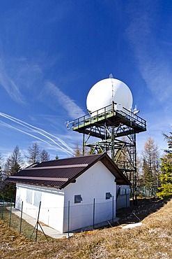
Precipitation Radar Station on Gantkofel Mountain, Mendel Ridge, Alto Adige, Italy, Europe

Tower of the weather station and market stall on the peak of Mont Ventoux, Vaucluse, Provence-Alpes-Cote d'Azur, Southern France, Europe
Weather station and old mountain refuge known as the "Zittelhaus" on the Sonnblick mountain, 3105m, Hohe Tauern National Park, Salzburg, Austria, Europe
Meteorological station on the summit of Mt Seebuck, Feldberg, southern Black Forest, Breisgau-Hochschwarzwald district, Baden-Wuerttemberg, Germany, Europe
Weather station on Mt. Rittnerhorn above the Renon, Bolzano Area, South Tyrol, Italy, Europe

Weather station on Mount Sonnblick (3105m), Hohe Tauern Range National Park, Salzburg, Austria, Europe

The weather radar system of the German Weather Service on the 1493m high Mt. Feldberg in the Black Forest, Landkreis Breisgau-Hochschwarzwald district, Baden-Wuerttemberg, Germany, Europe
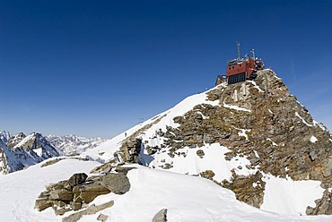
Meteorological station on Mt. Zugspitze, 2962m, Wettersteingebirge mountains, Werdenfels, Upper Bavaria, Bavaria, Germany,
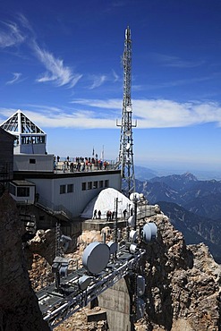
Meteorological station and transmission tower on Mt Zugspitze, Bavaria, Germany, Europe

Sign "Deutscher Wetterdienst", "German Weather Service", on Zugspitze mountain, Bavaria, Germany, Europe

Observatory and weather station, Mont Ventoux, Mt. Ventoux, Provence, Southern France, France, Europe

Mont Ventoux, Provence-Alpes-Cote dÃAzur, France, Europe
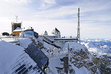
Aerial view, Mt. Kahler Asten weather station, snow, winter, Winterberg, North Rhine-Westphalia, Germany, Europe

TV tower, meteorological station, Brocken mountain, Harz, Saxony-Anhalt, Germany, Europe
Aerial view, Mt. Kahler Asten weather station, snow, winter, Winterberg, North Rhine-Westphalia, Germany, Europe

Mountainbikers and tower of the weather station on the peak of Mont Ventoux, Vaucluse, Provence-Alpes-Cote d'Azur, Southern France, Europe

Weather station, German Weather Service, Mt. Hoher Peissenberg or Hohenpeissenberg, Pfaffenwinkel, Upper Bavaria, Bavaria, Germany, Europe

Mt. Zugspitze, 2962m, summit station, summit house, Wettersteingebirge mountains, Upper Bavaria, Germany, Europe
Muenchner Haus alpine lodge and weather station on the summit of Mt. Zugspitze, 2962m, Wettersteingebirge mountains, Werdenfels, Upper Bavaria, Bavaria, Germany, Europe

Weather station on Rittner Horn Mountain above Renon, Bolzano area, Alto Adige, Italy, Europe
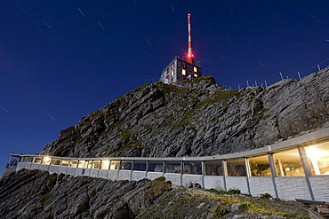
Moonlit pedestrian passage on Mt Saentis, Alpstein range, Appenzell region, Swiss Alps, Switzerland, Europe, PublicGround

Tower of the weather station on the peak of Mont Ventoux, Provence, South of France, Europe

Weather station on the Saentis mountain in full moon light, Alpstein, Appenzell Outer-Rhodes, Appenzell Inner-Rhoden, Switzerland, Europe, PublicGround
Weather station on Mt Rittnerhorn above Ritten, Renon, Bolzano district, South Tyrol, Italy, Europe
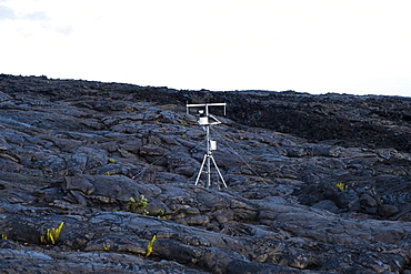
Weather station collecting data for the national park and weather service planted on old lava flows in Hawaii Volcanoes National Park
Power Station Surrounded By Barbed Wire Fences
The aircraft;DC-3 Basler) takes off from Concordia's snow-covered runway. Take-off of a Basler at Concordia. The runway is groomed very evenly to minimise the micro-relief on its surface and make it easier for the aircraft to take off. The aircraft are equipped with landing gear allowing them to land alternatively on a ?hard? runway or on snow: retractable skis controlled from the cockpit are fitted to the two front landing gears. Concordia Antarctic Research Station, Dome C plateau, East Antarctica.

A technician at the foot of the station holds a large evacuation sock into which a person is lowered. Once a month, all the staff carry out an emergency evacuation of the station using a ?sock?. The idea is to let yourself slide down a tube of fabric that slows your fall to such an extent that you can even stop yourself by spreading your arms and legs. A technician is waiting for us at the bottom to assist with the last metre of the descent. Concordia Antarctic Research Station, Dome C plateau, East Antarctica.
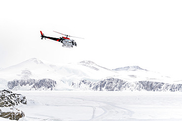
A German BGR helicopter used in Terre Victoria to transport geologists to specific research points. These are one-off scientific programs, involving the collaboration of several countries, in this case Germany and Italy. The Germans set up a base camp several dozen kilometers from the Italian Mario Zucchelli station, using Italian logistical resources such as the Laura Bassi icebreaker to transport the helicopter, the equipment needed to set up the base camp, scientific equipment and, of course, personnel. All of this was delivered to the Mario Zucchelli station for onward transport by helicopter to the search site. Victoria Land, Antarctica
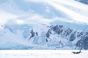
The Lockheed C-130 Hercules prepares to take off from the runway built on the sea ice in Terra Nova Bay, where the Mario Zucchelli station is located. Victoria Land, Antarctica
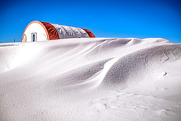
Snowdrift in front of a tent. A dormitory tent dating from the 1990s and still in use. It is heated by a small oil-fired stove. Every obstacle in the wind creates snowdrifts, which have to be removed periodically to prevent burial. Concordia Antarctic Research Station, Dome C plateau, East Antarctica.
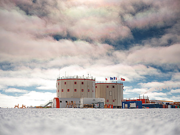
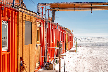
Concordia Station, Italian, European, French, Swiss and German flags. Tent, fire escape, containers, kerosene tanks, smoke from the power station, iridescent clouds. The station under a sky lightly covered with low, iridescent clouds. Concordia Antarctic Research Station, Dome C plateau, East Antarctica.

Concordia staff on their knees helping a person lying on a stretcher. Helped by a snowmobile. Rescue exercise in the event of an accident involving several victims. These frequent exercises are supervised by the doctor. All the resort's winter residents are assigned a very specific role in the event of an accident, illness or fire. A redundancy system allows this system to function in the event of one or more winterers failing to respond. Concordia Antarctic Research Station, Dome C plateau, East Antarctica.
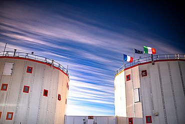
The two towers of the Concordia station, with the French, Italian and European flags flying in the wind, under a blue sky veiled with cirrus clouds aligned in the direction of the wind. The two towers are linked by a tunnel. They are permanently heated to 20°C by the diesel engine that generates the station's electricity. The left tower is the "quiet tower", housing the hospital, bedrooms;34 beds) and offices. The right tower is the "noisy tower": it houses a small workshop, the emergency generator, the waste room, the technical office, the video room, the living room, the kitchens and the refectory. The two towers are about ten meters apart to prevent the risk of fire spreading. Fire is an Antarctic expeditionary's worst nightmare; the French have a very bad experience of it. Concordia Antarctic Research Station, Dome C plateau, East Antarctica.
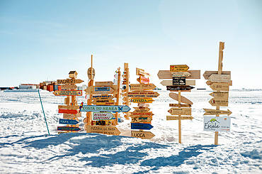
Village/town signs fixed on poles in front of the station/ Making and putting up a sign indicating the direction of one's home is a deeply rooted tradition in the stations. Concordia Antarctic Research Station, Dome C plateau, East Antarctica.
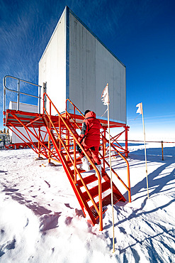
A technician goes into a raised square building on an orange metal structure. An Italian technician specialising in radio and telecommunications goes into the shelter that houses the VSAT antenna, the device that connects the station to the Internet by satellite. This is the station's only link with the outside world. Most of the buildings are elevated to prevent the formation of snowdrifts caused by wind-blown snow. Concordia Antarctic Research Station, Dome C plateau, East Antarctica.
Building made of containers lined up in a row, powered by pipes and electric cables. The summer camp is made up of containers assembled together. It was built in the early 1990s. Since then, irregular ground settlement has caused the building to deform. It is now used as a summer dormitory. Concordia Antarctic Research Station, Dome C plateau, East Antarctica.
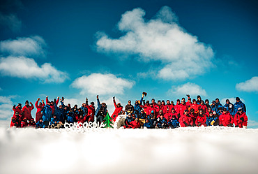
Concordia technicians and scientists, Christmas tree, Concordia in letters made of ice/snow, Igloo. Group photo of the team at Concordia during the summer. The Italians are in red and the French in blue. The ratio is about half Italians and half French; half technicians and half scientists. Concordia Antarctic Research Station, Dome C plateau, East Antarctica.

A technician rides an electric bike on the snow, passing a container and crates on the ground. A technician uses an electric fatbike to get to the summer camp area from the station. Immediately after arriving, he removes the electric battery and deposits it in the nearest building where the temperature is positive. If he forgets the battery outside, he will have to push the bike on the way back because the intense cold will have drained the battery. Concordia Antarctic Research Station, Dome C plateau, East Antarctica.

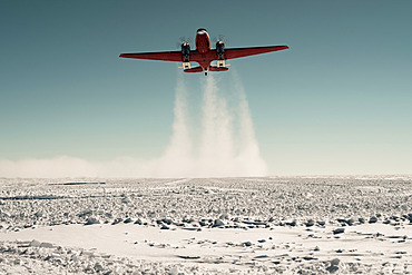
Technicians loading/unloading cargo/freight from the supply plane at Concordia. French;in blue) and Italian;in red) technicians help unload the Basler - Douglas DC3, which delivers scientific and/or technical equipment to the Concordia station several times a month during the summer. It takes a team of 6 to 20 people just 3 minutes to unload the 2 tonnes of cargo, reload the same amount of equipment into the plane and refuel the aircraft with kerosene. As soon as these operations are completed, the plane is ready to leave again. Concordia Antarctic Research Station, Dome C plateau, East Antarctica.

Landscape of Svalbard in Norway, also known as Spitsbergen. This territory stretches from latitude 75 to 80 degrees to the pack ice a few hundred kilometers from the North Pole. Melting ice, early global warming. Baie de la Madeleine here, a coastal landscape rising to 80 degrees latitude, where blocks of ice and small icebergs detached from glaciers drift on the water. Old steam train in front of Ny-Alesund weather station

Frozen ground of Dome C, and sastrugis. Sastrugis are wind-blown snow formations. The wind is not extremely strong in these high-altitude locations. Concordia Station, Antarctic
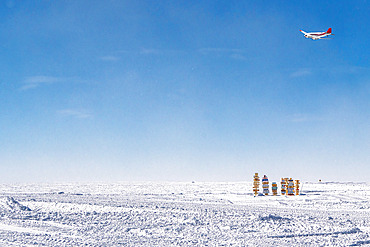
A few weeks after the start of the summer campaign, the winterers who have just spent 14 months at Concordia return home. They take off from Concordia station aboard the Basler;photo), bound for Mario Zucchelli or Dumont d'Urville. Most of them make a sign indicating the village or town where they live, and the distance to Concordia. Concordia Antarctic Base

A frozen lake at the heart of a landscape near the Mario Zucchelli station. Victoria Land, Antarctica