Results
13 results found

Mediterranean Katydid (Phaneroptera nana), France, Europe
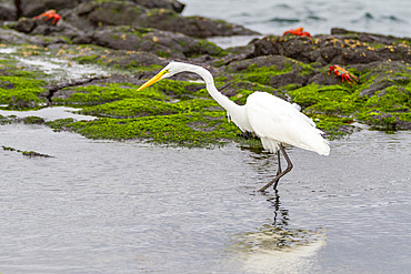
Adult great egret (Ardea alba egretta) feeding at low tide in the Galapagos Island Archipelago, UNESCO World Heritage Site, Ecuador, South America
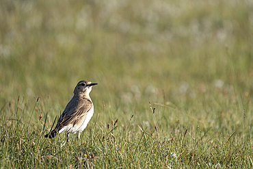
A photo of a bird, Kyrgyzstan, Central Asia, Asia
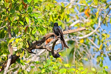
Fork-tailed Drongo (dicrurus adsimilis), Chobe National Park, Botswana

Young woman admiring a flight of grey heron at sunset by the Senanayake Samudraya Lake, Gal Oya National Park, Sri Lanka, Indian subcontinent, South Asia
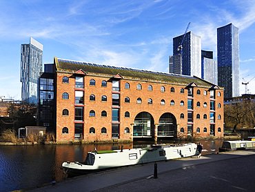
Merchants Warehouse Manchester, United Kingdom
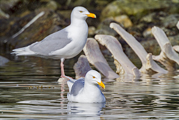
Adult glaucous gull (Larus hyperboreus) near fin whale carcass in the Svalbard Archipelago, Norway
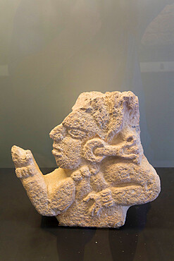
Stone Relief, Observer of the Sky, 600-800 AD, Museum, Fort San Jose, Campeche, State of Campeche, Mexico, North America
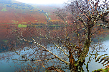
Buttermere, Lake District National Park, UNESCO World Heritage Site, Cumbria, England, United Kingdom, Europe
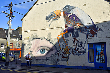
Graffiti wall painting in Eyre Street, Galway, Connemara, County Galway, Connacht, Republic of Ireland
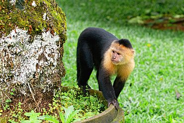
Panamanian white-faced capuchin (Cebus imitator), Costa Rica
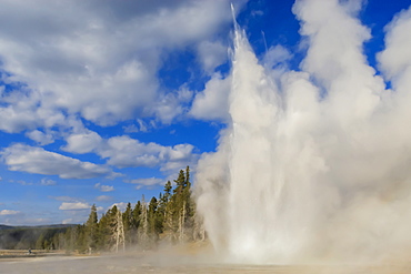
Lone observer watches Grand Geyser erupt, Upper Geyser Basin, Yellowstone National Park, UNESCO World Heritage Site, Wyoming, United States of America, North America
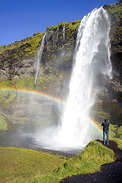
Seljalandsfoss Waterfall, South Iceland, Iceland, Polar Regions

A motorist travels far too fast through flood waters on the road at Storth on the Kent Estuary in Cumbria, UK, during the January 2014 storm surge and high tides.
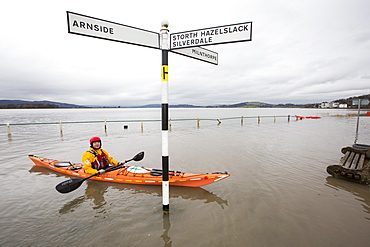
Kayakers in the flood waters on the road at Storth on the Kent Estuary in Cumbria, UK, during the January 2014 storm surge and high tides.
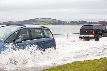
A motorist travels through flood waters on the road at Storth on the Kent Estuary in Cumbria, UK, during the January 2014 storm surge and high tides.

A motorist stuck in flood waters on the road at Storth on the Kent Estuary in Cumbria, UK, during the January 2014 storm surge and high tides, is pushed out by two helpers.
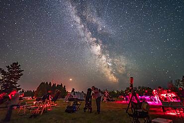
An observer gazes skyward with his Dobsonian reflector telescope at the Saskatchewan Summer Star Party on August 9, 2018, in the Cypress Hills of southwest Saskatchewan, at the Cypress Hills Interprovincial Park, a Dark Sky Preserve. The Milky Way shines to the south. Smoke in the sky obscures the horizon somewhat.

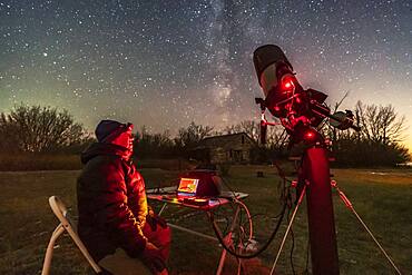
Photographer Stephen Bedingfield is shooting the Northern Lights at the Ramparts waterfalls on the Cameron River, September 8, 2019.
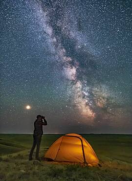
A Park interpreter poses for a scene in Grasslands National Park, Saskatchewan, of stargazing with binoculars under the Milky Way on a dark moonless night. Grasslands is perfect for stargazing as it is a Dark Sky Preserve and the horizon is vast and unobstructed.
A session shooting deep-sky objects in the rural backyard in Alberta, on a chilly November night, November 8, 2018. I was using the Celestron 8 HD tube assembly on the Astro-Physics Mach One mount, and was shooting Messier 27 with the Canon 6 D MkII. I shot this image with the Sony a7III and Venus Optics 15mm lens at f/2 focused on the foreground.
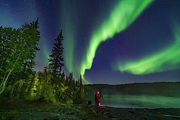
Photographer Stephen Bedingfield is shooting the Northern Lights at the Ramparts waterfalls on the Cameron River, September 8, 2019. The Big Dipper is at centre. The aspen trees are nicely turning colour.
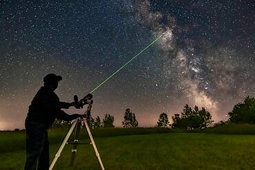
Me aiming the A&M 80mm refractor on the Astro-Tech Voyager mount at the Milky Way with its laser pointer finder showing the way. I am aiming at M11 in Scutum.
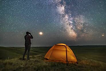
A Park interpreter poses for a scene in Grasslands National Park, Saskatchewan, of stargazing with binoculars under the Milky Way on a dark moonless night. Grasslands is perfect for stargazing as it is a Dark Sky Preserve and the horizon is vast and unobstructed.
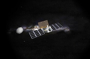
M-Argo asteroid observer spacecraft, artwork
Satellite view of Wallis Island, part of Wallis and Futuna Islands. This image was compiled from data acquired by Landsat 8 satellite in 2014.
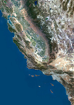
Color satellite image of San Francisco to Los Angeles, California, United States

Satellite view of Cuba and Jamaica. This image was compiled from data acquired by Landsat satellites.
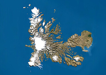
Satellite view of the Kerguelen Islands, a group of islands in the southern Indian Ocean that is part of the French Southern and Antarctic Lands
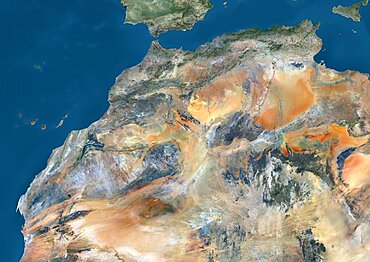
Satellite view of Algeria, Morocco and Tunisia. This image was compiled from data acquired in 2014 by Landsat 8 satellite.
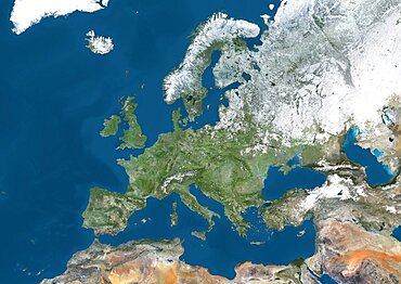
Satellite view of Europe in winter, with partial snow cover. This image was compiled from data acquired by Landsat 7 & 8 satellites.
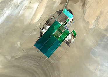
The satellite image shows potash evaporation ponds in Lop Nur, a former salt lake in the Xinjiang Region, that spread over 20 kilometers
Satellite view of Turks and Caicos Islands. This image was compiled from data acquired by Landsat satellites.
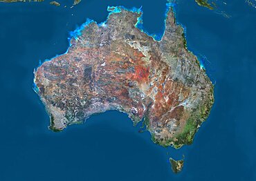
Satellite view of Australia. This image was compiled from data acquired by Landsat 8 satellite in 2014.
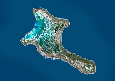
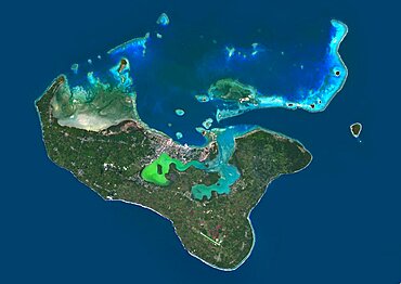
Satellite view of Christmas Island, Kiribati. This image was compiled from data acquired by Landsat 8 satellite in 2014.
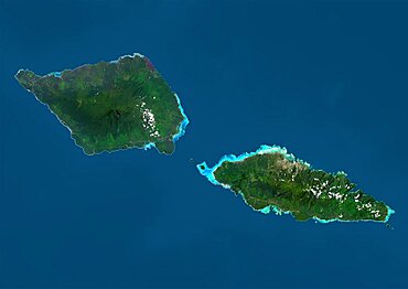
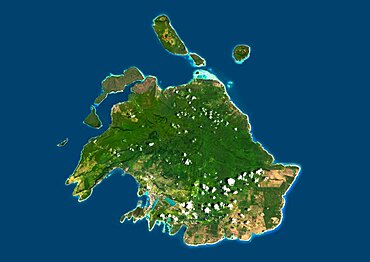
Satellite view of Samoa that consists of two large islands, Upolu and Savaii. This image was compiled from data acquired by Landsat 8 satellite in 2014.

Color satellite image of Tunis, capital city of Tunisia. Image collected on August 19, 2017 by Sentinel-2 satellites.
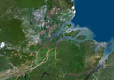
Color satellite image of the Amazon Delta, Brazil. Image collected by Landsat satellites.
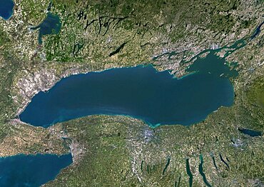
Color satellite image of Lake Ontario, North America. Image collected on May 1, 2016 by Landsat 8 satellite.

Satellite image of Abu Dhabi, United Arab Emirates, taken on June 26, 2014 by the satellite Landsat 8. The territory covered is 78 km x 55 km.
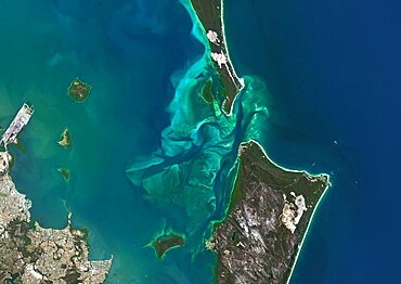
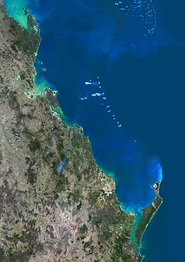
Satellite view of Moreton Bay, Queensland, Australia. This image was compiled from data acquired in 2014 by Landsat 8 satellite.
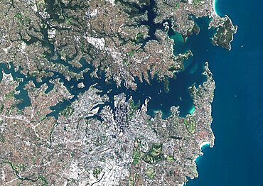
Color satellite image of Sydney, Australia. Image collected on August 23, 2017 by Sentinel-2 satellites.

Color satellite image of Manama, capital city of Bahrain. Image collected on October 17, 2017 by Sentinel-2 satellites.
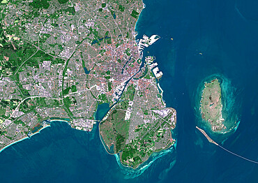
Color satellite image of Copenhagen, capital city of Denmark. The Oresund Bridge which is a combination of tunnel and bridge, connects Copenhagen to the Swedish city of Malmo. Image collected on May 27, 2017 by Sentinel-2 satellites.
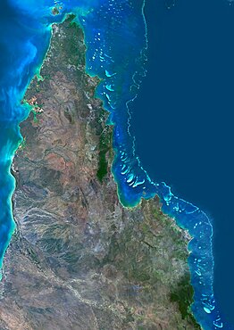
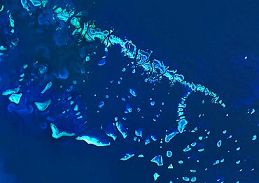
Satellite view of the Northern Great Barrier Reef along the east coast of Cape York Peninsula in north Australia. This image was compiled from data acquired in 2014 by Landsat 8 satellite.
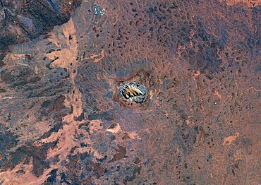
Satellite view of Uluru Ayers Rock, Northern Territory, Australia. This image was compiled from data acquired by Landsat satellites.
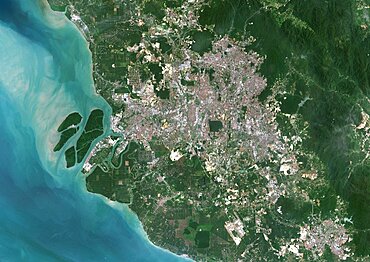
Color satellite image of Kuala Lumpur, capital city of Malaysia. Image collected on February 03, 2017 by Sentinel-2 satellites.
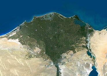
Color satellite image of the Nile Delta. It is formed in Northern Egypt where the Nile River spreads out and drains into the Mediterranean Sea. Image collected on October 1, 2017 by Sentinel-2 satellites.
Satellite view of Grand Cayman. It is the largest of the three Cayman Islands. This image was compiled from data acquired by Landsat satellites.

Satellite image of Typhoon Talim in 2017 over the East China Sea. Image taken on September 16, 2017.

Satellite view of Senegal River that forms the border between Senegal and Mauritania in West Africa.This image was taken in 2014 by Landsat 8 satellite.
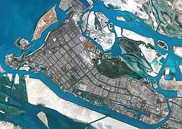
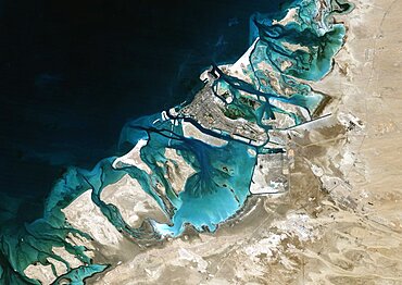
Color satellite image of Abu Dhabi, capital city of United Arab Emirates. The city is on an island connected by bridges to the mainland and other islands. Image collected on September 21, 2017 by Sentinel-2 satellites.
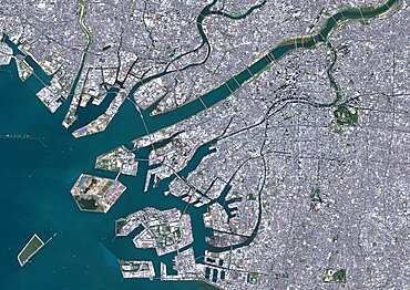
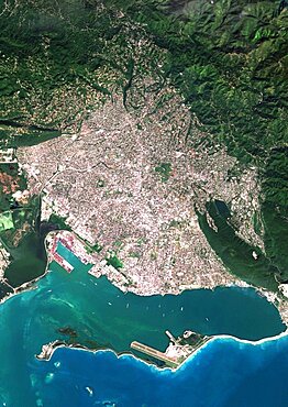
Color satellite image of Osaka, Japan. Image collected on November 02, 2016 by Sentinel-2 satellites.
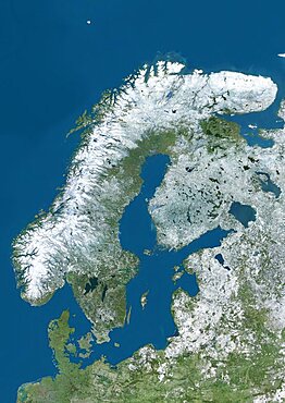
Satellite view of Northern Europe showing Scandinavia and the Baltic States in winter, with partial snow cover. This image was compiled from data acquired by Landsat 7 & 8 satellites.
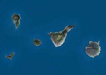
Satellite view of La Palma, Tenerife and Gran Canaria, Canary Islands, Spain. The smallest islands of La Gomera and El Hierro are also shown. This image was compiled from data acquired by Landsat 8 satellite in 2014.
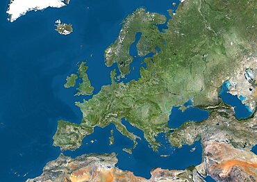
Satellite view of Europe. This image was compiled from data acquired by Landsat 7 & 8 satellites.
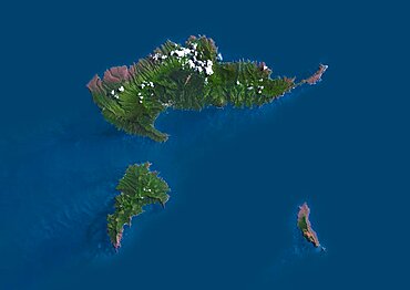
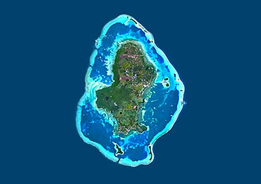
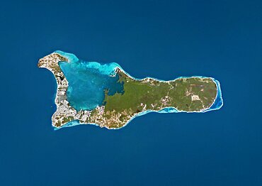
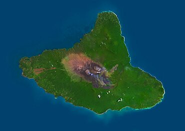
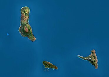
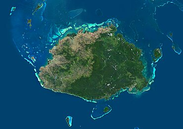
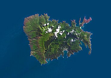
Satellite view of Hiva Oa, the second largest island in the Marquesas Islands, in French Polynesia. This image was compiled from data acquired by Landsat 8 satellite in 2014.
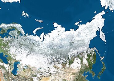
Satellite view of Russia and Central Asia in winter, with partial snow cover. This image was compiled from data acquired by Landsat 7 & 8 satellites.
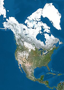
Satellite view of North America in winter, with partial snow cover. This image was compiled from data acquired by Landsat 7 & 8 satellites.
Satellite image of Abu Dhabi, United Arab Emirates, taken on February 2, 1985 by the satellite Landsat 5. The territory covered is 78 km x 55 km.
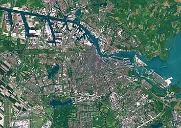
Color satellite image of Amsterdam, capital city of Netherlands. The River Amstel flows through the city. Image collected on May 26, 2017 by Sentinel-2 satellites.
Color satellite image of Miami Metropolitan Area, Florida, United States. The Everglades natural region is at west and Biscayne National Park at south. Image collected on January 06, 2017 by Sentinel-2 satellites.
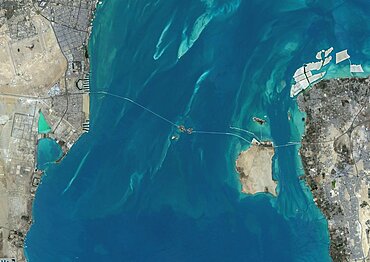
Satellite view of the King Fahd Causeway, a series of bridges and causeways connecting Saudi Arabia and Bahrain. This image was compiled from data acquired in 2014 by Landsat 8 satellite.

Satellite view of Africa. This image was compiled from data acquired by Landsat 7 & 8 satellites.
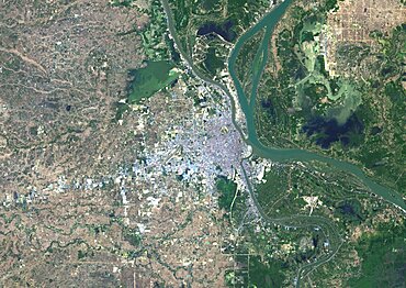
Colour satellite image of Phnom Penh, Cambodia. This image was taken on January 15, 2015 by Landsat 8 satellite.

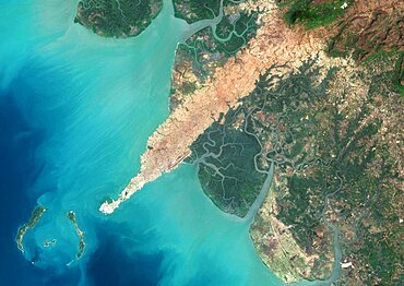
Satellite view of Adam's Bridge. This chain of limestone shoals connects Sri Lanka to India. This image was taken in 2014 by Landsat 8 satellite.
Satellite view of Efate, Vanuatu. It is the most populous island of Vanuatu archipelago. This image was compiled from data acquired by Landsat 8 satellite in 2014.
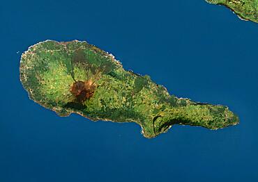
Satellite view of Ambrym, a volcanic island in the archipelago of Vanuatu. This image was compiled from data acquired by Landsat 8 satellite in 2014.
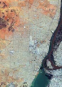
Color satellite image of Omdurman, Sudan. The city lies on the western banks of the River Nile, opposite the capital Khartoum. Image collected on October 25, 2017 by Sentinel-2 satellites.
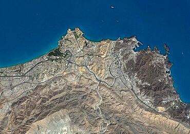
Color satellite image of Conakry, capital city of Guinea. Image collected on March 03, 2017 by Sentinel-2 satellites.
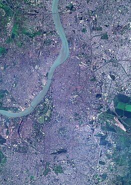
Color satellite image of Kolkata, India. The city is located on the east bank of the Hooghly River. Image collected on March 16, 2017 by Sentinel-2 satellites.
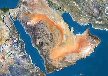
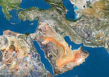
Satellite view of the Arabian Peninsula. This image was compiled from data acquired in 2014 by Landsat 8 satellite.
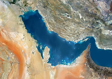
Satellite view of the Persian Gulf. This image was compiled from data acquired in 2014 by Landsat 8 satellite.
Satellite view of the Comoros Archipelago. This image was compiled from data acquired by Landsat satellites.
Color satellite image of Kingston, capital city of JaMayca. Image collected on December 16, 2017 by Sentinel-2 satellites.
Color satellite image of Muscat, capital city of Oman. Image collected on October 18, 2017 by Sentinel-2 satellites.

Satellite view of Rarotonga, Cook Islands. This is the most populous island of the Cook Islands. This image was compiled from data acquired by Landsat 8 satellite in 2014.
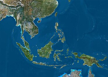
Satellite view of Southeast Asia. This image was compiled from data acquired by Landsat 7 & 8 satellites.
Satellite view of Tahiti, French Polynesia. This image was compiled from data acquired by Landsat 8 satellite in 2014.

Color satellite image of Port-au-Prince, capital city of Haiti. Image collected on March 25, 2017 by Sentinel-2 satellites.
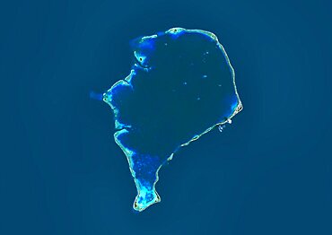
Satellite view of Funafuti, an atoll on which the capital of the island nation of Tuvalu is located. This image was compiled from data acquired by Landsat 8 satellite in 2014.
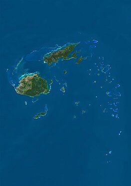
Satellite view of the Fiji Islands. This image was compiled from data acquired by Landsat 8 satellite in 2014.
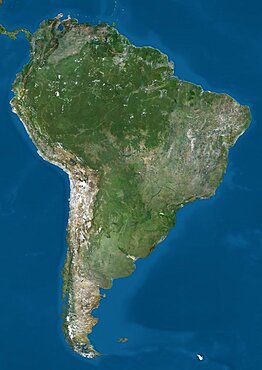
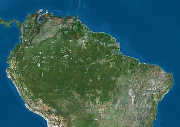
Satellite view of South America. This image was compiled from data acquired by Landsat 7 & 8 satellites.
Satellite view of Viti Levu Island, Fiji. This is the largest island in the Republic of Fiji and the site of the nation's capital, Suva. This image was compiled from data acquired by Landsat 8 satellite in 2014.
Satellite view of Pico Island, Azores, Portugal. Volcano Mount Pico, to the West, is the highest point in Portugal, at 2351 m, and the most famous landmark in the Azores. This image was compiled from data acquired by Landsat satellites.
Satellite view of the Middle East. This image was compiled from data acquired in 2014 by Landsat 8 satellite.
Satellite view of the Southern Great Barrier Reef and Fraser Island along Queensland's coastline in north-east Australia. This image was compiled from data acquired in 2014 by Landsat 8 satellite.

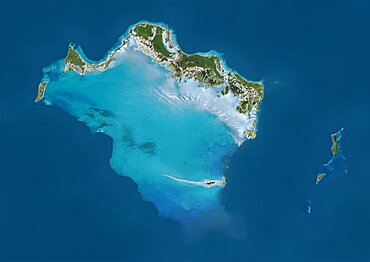
Satellite view of the Abaco Islands that lie in the northern Bahamas
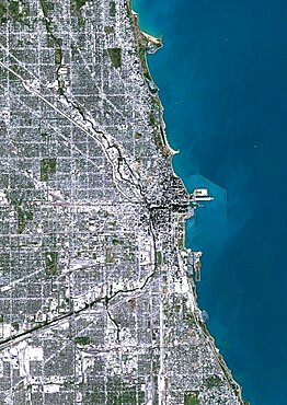
Color satellite image of Chicago, Illinois, United States. The city is located at the south western tip of Lake Michigan. Image collected on October 08, 2017 by Sentinel-2 satellites.
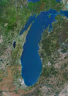
Color satellite image of Lake Michigan, United States. Image collected on May 1, 2016 by Landsat 8 satellite.
Satellite view of Nuku Hiva, the largest of the Marquesas Islands in French Polynesia. This image was compiled from data acquired by Landsat 8 satellite in 2014.
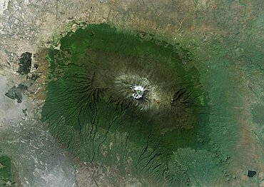
Satellite view of Mount Kilimanjaro, Tanzania. This dormant volcano is the highest mountain in Africa. It is part of the Kilimanjaro National Park. This image was compiled from data acquired by Landsat satellites.
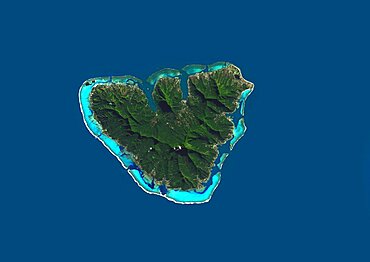
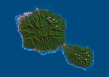
Satellite view of Moorea, French Polynesia. This image was compiled from data acquired by Landsat 8 satellite in 2014.
Satellite view of Northern South America. This image was compiled from data acquired by Landsat 7 & 8 satellites.
Satellite view of Tongatapu, the largest island of Tonga archipelago. This image was compiled from data acquired by Landsat 8 satellite in 2014.

Satellite view of Crete, Greece. Crete is the largest and most populous of the Greek islands. This image was compiled from data acquired by Landsat 8 satellite in 2014.
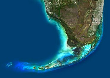
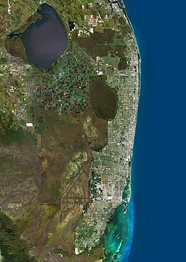
Color satellite image of Southern Florida, United States. It shows Miami at east, Everglades National Park at center, and the Florida Keys at south. Image collected on January 06, 2017 by Sentinel-2 satellites.
Satellite view of the Great Barrier Reef, Australia, off Mackay's coast. This image was compiled from data acquired in 2014 by Landsat 8 satellite.
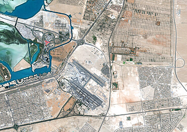
Color satellite image of Abu Dhabi International Airport, United Arab Emirates. The amusement park Ferrari World Abu Dhabi is on Yas Island, at center left on the image. Image collected on September 21, 2017 by Sentinel-2 satellites.
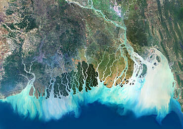
Satellite image of the Ganges River Delta, Bangladesh, India. Also known as the Brahmaputra Delta