Results
4 results found
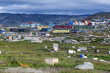
Overlook over Ilulissat, Western Greenland, Denmark, Polar Regions
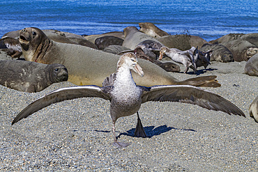
Northern giant petrels (Macronectes halli) fighting over the scavenging rights to a dead elephant seal pup at Royal Harbor, South Georgia
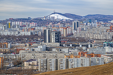
Overlook over Krasnoyarsk, Siberia, Russia
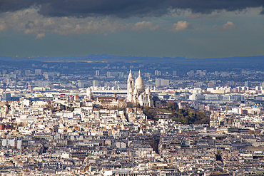
Aerial view over city including Basilique du Sacre-Coeur, Paris, France
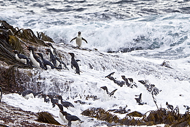
Adult Southern Rockhopper Penguins (Eudyptes chrysocome chrysocome) in the Falkland Islands. This is the smallest yellow-crested, black-and-white penguin in the genus Eudyptes. It reaches a length of 45-58 cm (18-23 in) and typically weighs 2-3.4 kg (4.4-7.5 lb), although there are records of exceptionally large rockhoppers weighing 5 kg (11 lbs). Their common name refers to the fact that unlike many other penguins which negotiate obstacles by sliding on their bellies or by awkward climbing using their flipper-like wings as aid, Rockhoppers will try to jump over boulders and across cracks. This behavior is by no means unique to this species however - at least the other "crested" penguins of the genus Eudyptes hop around rocks too. Southern Rockhopper Penguins have a global population of roughly 1 million pairs, perhaps a bit more. About two-thirds of the global population belongs to E. c. chrysocome which breeds on the Falkland Islands and on islands off Argentina and southern Chile. The Southern Rockhopper Penguin is classified as Vulnerable species by the IUCN.
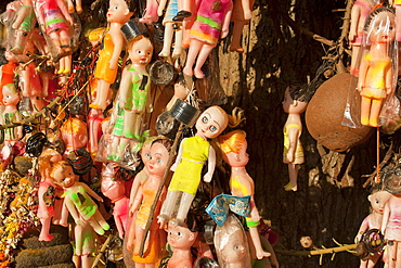
1000s of white dolls hung grotesquely on a canon ball tree for fertility, in the Janardhana swamy Hindu temple in Varkala,Kerala, India. more info: We need to question our need to reproduce more and more of us. As over population is the root of most of our problems.
Dancers during a wedding, Sufi shrine, Bareilly, Uttar Pradesh, India, Asia
Sheikh Medimir Niazi, group picture during his wedding, Sufi shrine, Bareilly, Uttar Pradesh, India, Asia

Traditional funeral, people standing around a body on a pyre, while an untouchable priest of the lowest caste spreads wet reed over the body, Pashupatinath, Nepal, Asia
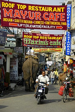
Colorful banners over an elephant, moped and people in a street in Udaipur, Rajasthan, India, Asia
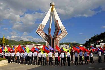
Parade, flag-bearers, young men of the Laotian Youth Organization Lao Youth with many colorful flags standing around a communist monuments, Xam Neua, Houaphan province, Laos, Southeast Asia, Asia
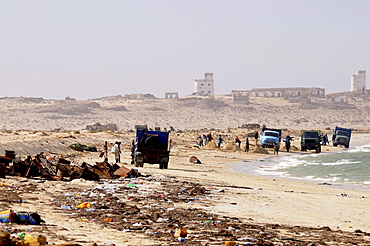
People collecting metal and other parts of rusting ships left over at the ship cemetery of Nouadhibou, Mauritania, Africa
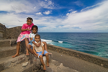
Three smiling children, San Antao, Cabo Verde, Cape Verde, Africa
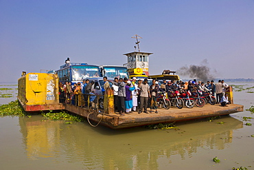
Ferry across the Madhumati river, Bangladesh, Asia
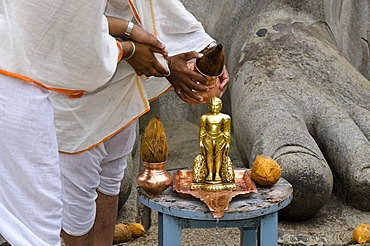
Two Jain pilgrims are pouring water over a small statue at the feet of the statue of Lord Gomateshwara, the tallest monolithic statue in the world, dedicated to Lord Bahubali, carved out of a single block of granite stone, 18 meters high, 983 AD, Sravanab
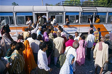
People trying to enter an already overloaded public bus in Bhuj, Gujarat, India, Asia
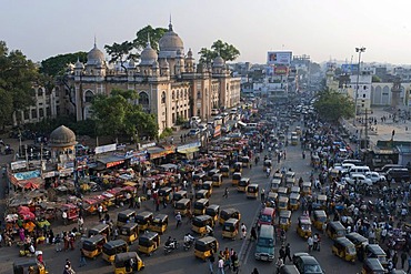
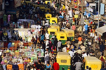
View from the Charminar on a busy road, Hyderabad, Andhra Pradesh, India, Asia
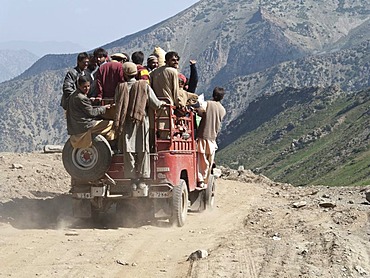
Overloaded jeep after crossing the Babusar Pass on the way down to Chillas, North West Frontier, Pakistan, South Asia
Heavy traffic in the capital of Gujarat, Ahmedabad, Gujarat, India, Asia
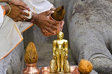
Two Jain pilgrims are pouring water over a small statue at the feet of the statue of Lord Gomateshwara, the tallest monolithic statue in the world, dedicated to Lord Bahubali, carved out of a single block of granite stone, 18 meters high, 983 AD, Sravanab
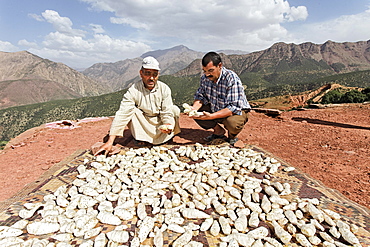
Mohammed El Malaoui checking the quality of the dried rhizomes of organically cultivated Irises (Iris germanica), which are stored on the roof of the mud house of Hassan Bouship, the chief of the village of Iwasoudane, for natural cosmetics in Europe, Ait Inzel Gebel Region, Atlas Mountains, Morocco, Africa
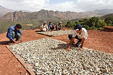
Residents of the village of Iwasoudanei checking the quality of the dried rhizomes of organically cultivated Irises (Iris germanica), which are stored on the roof of the mud house of Hassan Bouship, the chief of the village of Iwasoudane, for natural cosmetics in Europe, Ait Inzel Gebel Region, Atlas Mountains, Morocco, Africa
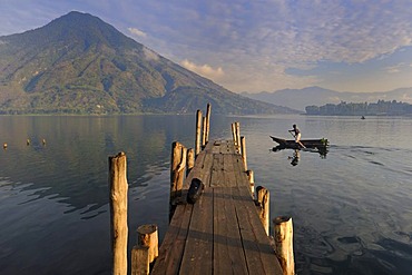
Dock, boat, Lake Atitlan, San Pedro volcano, fisherman, Guatemala, Central America

View of the street in front of the cathedral, city view, Bafoussam, Cameroon, Africa
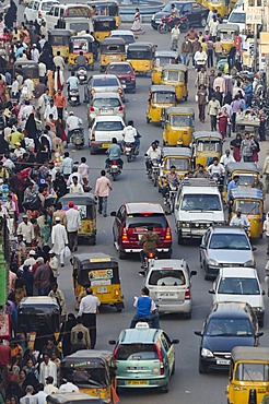
Busy street, Charminar, Hyderabad, Andhra Pradesh, India, Asia

Ferry across the Madhumati river, Bangladesh, Asia

Afghan men pause on the road with an ancient brick minaret and many shrines in the background, outside of Ghazni, Afghanistan, October 1, 2002. Made of brick decorated with Kufic and Naksh Script and floral motifs, the minaret dates back to the early 12th century and was built by Sultan Masud III of the Ghaznavid Dynasty, who ruled over an empire encompassing much of Afghanistan, Northern India, Persia and Central Asia. The minaret was once three times as tall as its current 70 feet, and is thought to have been part of a large mosque complex. Now an important truck stop on the road to Kandahar, Ghazni, located on the Lora River at the elevation of 2,225 meters, is the capital of Ghazni province with a population of 35,900, and is a market for sheep, wool, camel hair cloth, corn, and fruit, and continues to be a haven for Taliban insurgents.

Men on bikes ride past an ancient brick minaret toward the old walls and citadel of the town of Ghazni, Afghanistan, October 1, 2002. Made of brick decorated with Kufic and Naksh Script and floral motifs, the minaret dates back to the early 12th century and was built by Sultan Masud III of the Ghaznavid Dynasty, who ruled over an empire encompassing much of Afghanistan, Northern India, Persia and Central Asia. The minaret was once three times as tall as its current 70 feet, and is thought to have been part of a large mosque complex. Now an important truck stop on the road to Kandahar, Ghazni, located on the Lora River at the elevation of 2,225 meters, is the capital of Ghazni province with a population of 35,900, and is a market for sheep, wool, camel hair cloth, corn, and fruit.
The Louisiade Archipelago is a string of ten larger volcanic islands frequently fringed by coral reefs, and 90 smaller coral islands located 200 km southeast of New Guinea, stretching over more than 160 km and spread over an ocean area of 26,000 km? between the Solomon Sea to the north and the Coral Sea to the south. The aggregate land area of the islands is about 1,790 km? (690 square miles), with Vanatinai (formerly Sudest or Tagula as named by European claimants on Western maps) being the largest.Sideia Island and Basilaki Island lie closest to New Guinea, while Misima, Vanatinai, and Rossel islands lie further east. The archipelago is divided into the Local Level Government (LLG) areas Louisiade Rural (western part, with Misima), and Yaleyamba (western part, with Rossell and Tagula islands. The LLG areas are part of Samarai-Murua District district of Milne Bay. The seat of the Louisiade Rural LLG is Bwagaoia on Misima Island, the population center of the archipelago.
The Louisiade Archipelago is a string of ten larger volcanic islands frequently fringed by coral reefs, and 90 smaller coral islands located 200 km southeast of New Guinea, stretching over more than 160 km and spread over an ocean area of 26,000 km? between the Solomon Sea to the north and the Coral Sea to the south. The aggregate land area of the islands is about 1,790 km? (690 square miles), with Vanatinai (formerly Sudest or Tagula as named by European claimants on Western maps) being the largest. Sideia Island and Basilaki Island lie closest to New Guinea, while Misima, Vanatinai, and Rossel islands lie further east. The archipelago is divided into the Local Level Government (LLG) areas Louisiade Rural (western part, with Misima), and Yaleyamba (western part, with Rossell and Tagula islands. The LLG areas are part of Samarai-Murua District district of Milne Bay. The seat of the Louisiade Rural LLG is Bwagaoia on Misima Island, the population center of the archipelago.

Nimoa Island - here the island mission will impress. The five-sided church features murals of island life and all mission buildings are surrounded by well maintained paths and gardens filled with flowering plants. Edged by jungle-covered mountains, postcard beaches and crystal clear waters - an island paradise indeed! The Louisiade Archipelago is a string of ten larger volcanic islands frequently fringed by coral reefs, and 90 smaller coral islands located 200 km southeast of New Guinea, stretching over more than 160 km and spread over an ocean area of 26,000 km? between the Solomon Sea to the north and the Coral Sea to the south. The aggregate land area of the islands is about 1,790 km? (690 square miles), with Vanatinai (formerly Sudest or Tagula as named by European claimants on Western maps) being the largest. Sideia Island and Basilaki Island lie closest to New Guinea, while Misima, Vanatinai, and Rossel islands lie further east. The archipelago is divided into the Local Level Government (LLG) areas Louisiade Rural (western part, with Misima), and Yaleyamba (western part, with Rossell and Tagula islands. The LLG areas are part of Samarai-Murua District district of Milne Bay. The seat of the Louisiade Rural LLG is Bwagaoia on Misima Island, the population center of the archipelago.
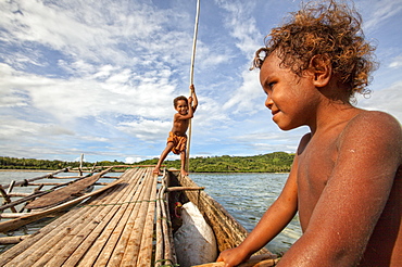
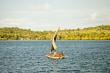
Children playing with a outrigger canoe in the village of Hessessai Bay at PanaTinai (Panatinane)island in the Louisiade Archipelago in Milne Bay Province, Papua New Guinea. The island has an area of 78 km2. The Louisiade Archipelago is a string of ten larger volcanic islands frequently fringed by coral reefs, and 90 smaller coral islands located 200 km southeast of New Guinea, stretching over more than 160 km and spread over an ocean area of 26,000 km? between the Solomon Sea to the north and the Coral Sea to the south. The aggregate land area of the islands is about 1,790 km? (690 square miles), with Vanatinai (formerly Sudest or Tagula as named by European claimants on Western maps) being the largest. Sideia Island and Basilaki Island lie closest to New Guinea, while Misima, Vanatinai, and Rossel islands lie further east. The archipelago is divided into the Local Level Government (LLG) areas Louisiade Rural (western part, with Misima), and Yaleyamba (western part, with Rossell and Tagula islands. The LLG areas are part of Samarai-Murua District district of Milne Bay. The seat of the Louisiade Rural LLG is Bwagaoia on Misima Island, the population center of the archipelago.PanaTinai (Panatinane) is an island in the Louisiade Archipelago in Milne Bay Province, Papua New Guinea.

Nimoa Island - here the island mission will impress. The five-sided church features murals of island life and all mission buildings are surrounded by well maintained paths and gardens filled with flowering plants. Edged by jungle-covered mountains, postcard beaches and crystal clear waters - an island paradise indeed! The Louisiade Archipelago is a string of ten larger volcanic islands frequently fringed by coral reefs, and 90 smaller coral islands located 200 km southeast of New Guinea, stretching over more than 160 km and spread over an ocean area of 26,000 km? between the Solomon Sea to the north and the Coral Sea to the south. The aggregate land area of the islands is about 1,790 km? (690 square miles), with Vanatinai (formerly Sudest or Tagula as named by European claimants on Western maps) being the largest. Sideia Island and Basilaki Island lie closest to New Guinea, while Misima, Vanatinai, and Rossel islands lie further east. The archipelago is divided into the Local Level Government (LLG) areas Louisiade Rural (western part, with Misima), and Yaleyamba (western part, with Rossell and Tagula islands. The LLG areas are part of Samarai-Murua District district of Milne Bay. The seat of the Louisiade Rural LLG is Bwagaoia on Misima Island, the population center of the archipelago.

Nimoa Island - here the island mission will impress. The five-sided church features murals of island life and all mission buildings are surrounded by well maintained paths and gardens filled with flowering plants. Edged by jungle-covered mountains, postcard beaches and crystal clear waters - an island paradise indeed! The Louisiade Archipelago is a string of ten larger volcanic islands frequently fringed by coral reefs, and 90 smaller coral islands located 200 km southeast of New Guinea, stretching over more than 160 km and spread over an ocean area of 26,000 km? between the Solomon Sea to the north and the Coral Sea to the south. The aggregate land area of the islands is about 1,790 km? (690 square miles), with Vanatinai (formerly Sudest or Tagula as named by European claimants on Western maps) being the largest. Sideia Island and Basilaki Island lie closest to New Guinea, while Misima, Vanatinai, and Rossel islands lie further east. The archipelago is divided into the Local Level Government (LLG) areas Louisiade Rural (western part, with Misima), and Yaleyamba (western part, with Rossell and Tagula islands. The LLG areas are part of Samarai-Murua District district of Milne Bay. The seat of the Louisiade Rural LLG is Bwagaoia on Misima Island, the population center of the archipelago.

Commuters on their way home on Beijing's subway, China.