Results
19 results found
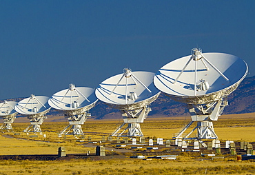
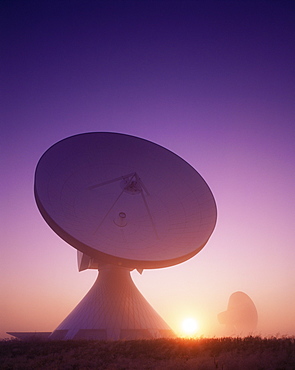
VLA (Very Large Array) of the National Radio Astronomy Observatory, New Mexico, United States of America, North America

A satellite tracked osprey (Pandion haliaetus) flying above a small loch with a fish in its talons, Scotland, United Kingdom, Europe

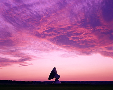
VLA (Very Large Array) of the National Radio Astronomy Observatory, New Mexico, United States of America, North America
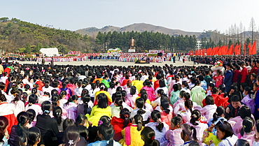
Celebrations on the 100th anniversary of the birth of President Kim Il Sung on April 15th 2012, in Pyongshong, a satellite city outside Pyongyang, Democratic People's Republic of Korea (DPRK), North Korea, Asia
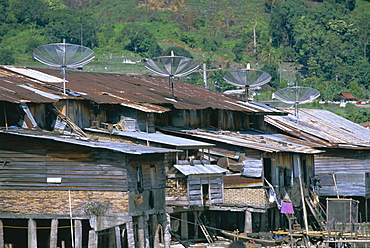
Stilt houses with satellite dishes, Haranggaol, north shore of Lake Toba, North Sumatra, Sumatra, Indonesia, Southeast Asia, Asia

Celebrations on the 100th anniversary of the birth of President Kim Il Sung on April 15th 2012, in Pyongshong, a satellite city outside Pyongyang, Democratic People's Republic of Korea (DPRK), North Korea, Asia
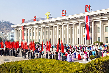
Celebrations on the 100th anniversary of the birth of President Kim Il Sung on April 15th 2012, Pyongshong, satellite city outside Pyongyang, Democratic People's Republic of Korea (DPRK), North Korea, Asia

Celebrations on the 100th anniversary of the birth of President Kim Il Sung on April 15th 2012, Pyongshong, satellite city outside Pyongyang, Democratic People's Republic of Korea (DPRK), North Korea, Asia

Celebrations on the 100th anniversary of the birth of President Kim Il Sung on April 15th 2012, Pyongshong, satellite city outside Pyongyang, Democratic People's Republic of Korea (DPRK), North Korea, Asia
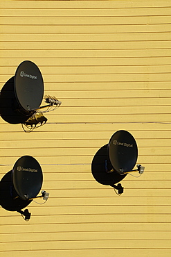
Satellite dishes, Norway, Europe

Celebrations on the 100th anniversary of the birth of President Kim Il Sung on April 15th 2012, Pyongshong, satellite city outside Pyongyang, Democratic People's Republic of Korea (DPRK), North Korea, Asia
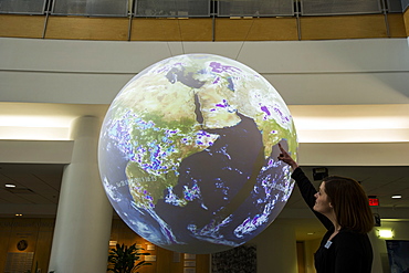
National Weather Center's Science on a sphere Norman, Oklahoma, United States of America, North America

Shark scientist monitors live satellite tagged great white shark (Carcharodon carcharias) on computer, Western Cape, South Africa, Africa
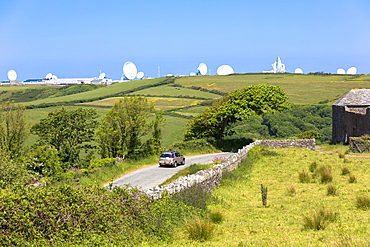
Satellite antenna dish at GCHQ Bude Satellite Listening Station (Government Communications Headquarters) defence at Cleave Camp, Cornwall, England, United Kingdom, Europe
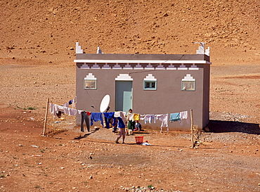
Traditional house with satellite dish outside, near Ouarzazate, Morocco, North Africa, Africa
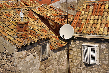
Close-up of roof tiles, old stone walls and satellite dish in the old town of Dubrovnik, Croatia, Europe
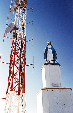
Statue of the Virgin Mary and communications tower, Vicuna, Elqui Valley, Chile, South America
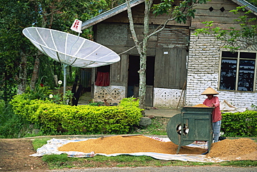
Satellite dish and man with rice winnowing machine, Lake Maninjau, Sumatra, Indonesia, Southeast Asia, Asia
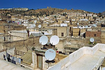
Satellite dishes in the old city or medina, Fez, Morocco, North Africa, Africa
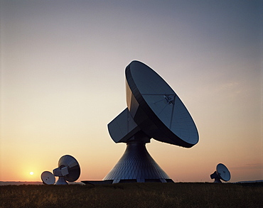
Satellite station at Raisting, Bavaria, Germany, Europe
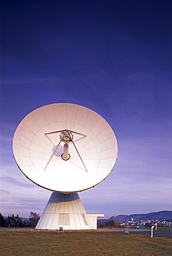
Satellite dish, Fuchsstadt, Bavaria, Germany, Europe

A satellite dish in front of Annapurna South summit, Annapurna Sanctuary, Himalayas, Nepal, Asia
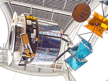
A satellite at the National Space Centre in Leicester, England, United Kingdom, Europe
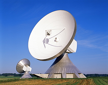
Satellite station at Raisting, Bavaria, Germany, Europe
Satellite station at Raisting, Bavaria, Germany, Europe
Satellite station at Raisting, Bavaria, Germany, Europe
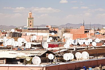
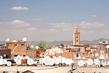
Satellite TV dishes on house roofs in Marrakech, Morocco, North Africa, Africa
Satellite TV dishes on house roofs in Marrakech, Morocco, North Africa, Africa
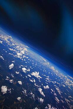
Clouds in Earth atmosphere viewed from space
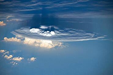
Cumulonimbus Cloud with Overshooting Cloud Tops
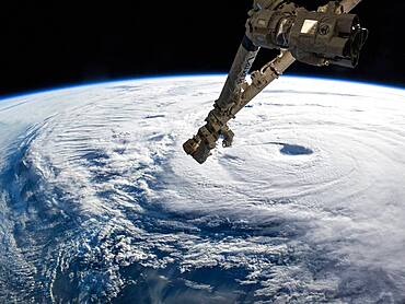
ISS and the Eye of Typhoon Neoguri
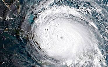
Hurricane Irma
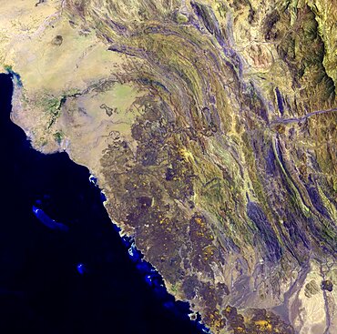
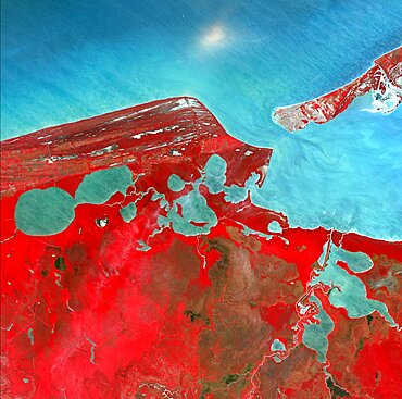
Harrat Al Birk, Saudi Arabia
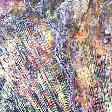
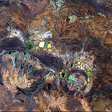
Saharan desert rivers, satellite image

Lake Chad, 1973 and 2013
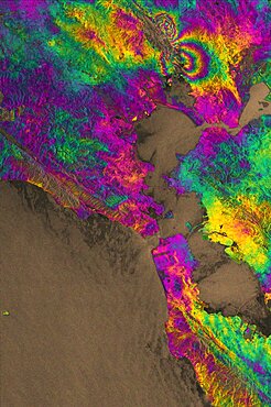
Napa Valley Earthquake, 2014, Interferogram
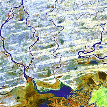
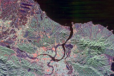
Amazon River, Manaus, Brazil
Campeche, Mexico
Kamchatka Peninsula, Russia
Salt Lake City, Utah
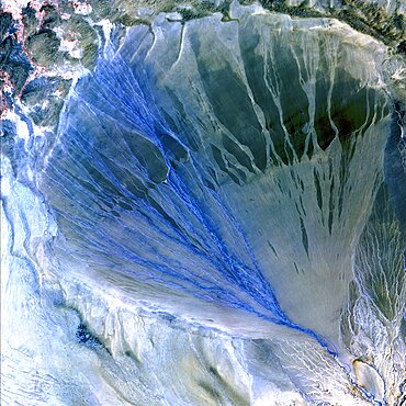
Alluvial Fan, China
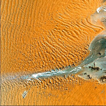
Namib Desert, Namibia
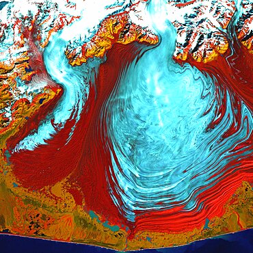
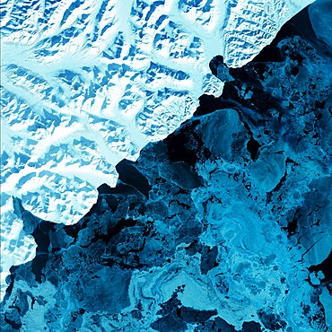
Malaspina Glacier, Alaska
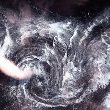
Whirlpool in the Air
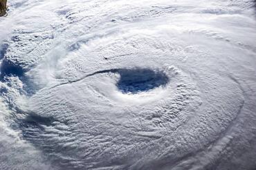
The Eye of Typhoon Neoguri
Kalahari Desert, Namibia

Hurricane Jose and Hurricane Maria, 2017
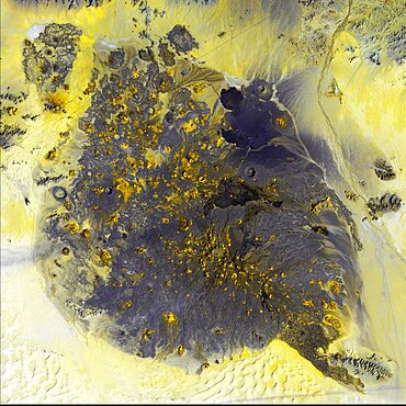
Pinacate Volcano Field, Mexico
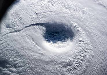
The Eye of Typhoon Neoguri
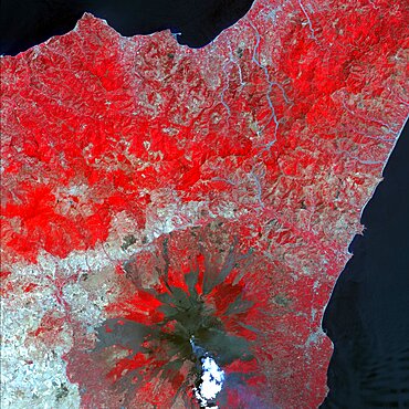
Mt. Etna, Sicily
Taipei, Taiwan
Shoemaker Crater, Landsat Image
Unzen Volcano, Japan
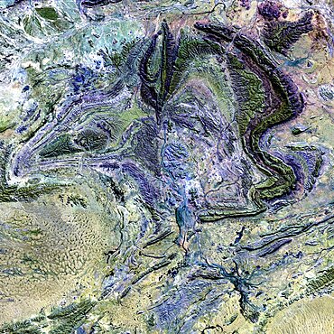
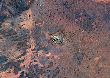
The MacDonnell Ranges, Australia
Dnieper River, Ukraine

Karman Vortex Cloud Streets From Space
Namibia Sand Dunes, SIR-C/X-SAR Image
Barstow, California
Piñon Canyon Region, Colorado
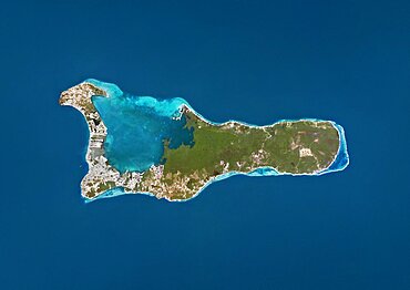
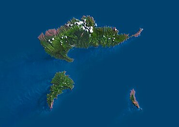
Satellite view of Wallis Island, part of Wallis and Futuna Islands. This image was compiled from data acquired by Landsat 8 satellite in 2014.

Satellite view of Cuba and Jamaica. This image was compiled from data acquired by Landsat satellites.
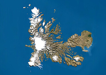
Satellite view of the Kerguelen Islands, a group of islands in the southern Indian Ocean that is part of the French Southern and Antarctic Lands
Satellite view of Europe in winter, with partial snow cover. This image was compiled from data acquired by Landsat 7 & 8 satellites.
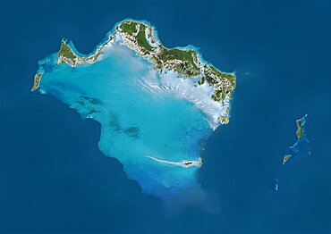
Satellite view of Turks and Caicos Islands. This image was compiled from data acquired by Landsat satellites.
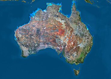
Satellite view of Australia. This image was compiled from data acquired by Landsat 8 satellite in 2014.
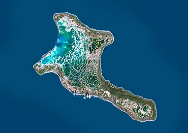
Satellite view of Christmas Island, Kiribati. This image was compiled from data acquired by Landsat 8 satellite in 2014.
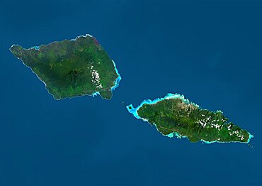
Satellite view of Samoa that consists of two large islands, Upolu and Savaii. This image was compiled from data acquired by Landsat 8 satellite in 2014.

Color satellite image of Tunis, capital city of Tunisia. Image collected on August 19, 2017 by Sentinel-2 satellites.
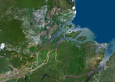
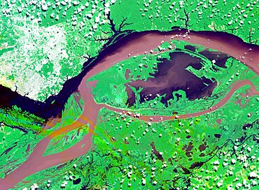
Color satellite image of the Amazon Delta, Brazil. Image collected by Landsat satellites.
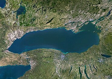
Color satellite image of Lake Ontario, North America. Image collected on May 1, 2016 by Landsat 8 satellite.

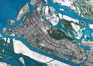
Satellite image of Abu Dhabi, United Arab Emirates, taken on June 26, 2014 by the satellite Landsat 8. The territory covered is 78 km x 55 km.
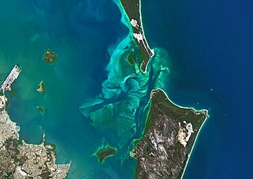
Satellite view of Moreton Bay, Queensland, Australia. This image was compiled from data acquired in 2014 by Landsat 8 satellite.
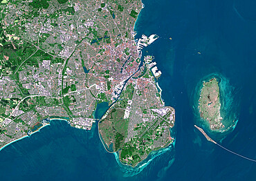
Color satellite image of Copenhagen, capital city of Denmark. The Oresund Bridge which is a combination of tunnel and bridge, connects Copenhagen to the Swedish city of Malmo. Image collected on May 27, 2017 by Sentinel-2 satellites.
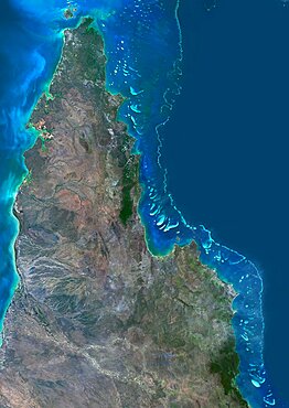
Satellite view of the Northern Great Barrier Reef along the east coast of Cape York Peninsula in north Australia. This image was compiled from data acquired in 2014 by Landsat 8 satellite.
Satellite view of Uluru Ayers Rock, Northern Territory, Australia. This image was compiled from data acquired by Landsat satellites.
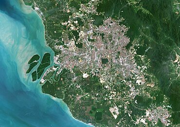
Color satellite image of Kuala Lumpur, capital city of Malaysia. Image collected on February 03, 2017 by Sentinel-2 satellites.
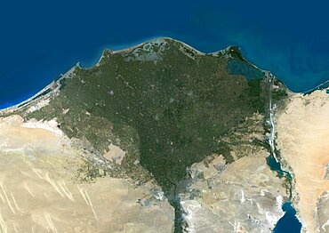
Color satellite image of the Nile Delta. It is formed in Northern Egypt where the Nile River spreads out and drains into the Mediterranean Sea. Image collected on October 1, 2017 by Sentinel-2 satellites.
Satellite view of Grand Cayman. It is the largest of the three Cayman Islands. This image was compiled from data acquired by Landsat satellites.

Satellite image of Typhoon Talim in 2017 over the East China Sea. Image taken on September 16, 2017.
Color satellite image of Abu Dhabi, capital city of United Arab Emirates. The city is on an island connected by bridges to the mainland and other islands. Image collected on September 21, 2017 by Sentinel-2 satellites.
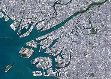
Color satellite image of Osaka, Japan. Image collected on November 02, 2016 by Sentinel-2 satellites.
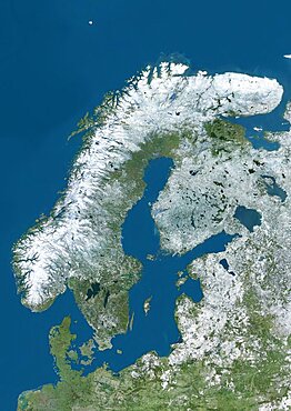
Satellite view of Northern Europe showing Scandinavia and the Baltic States in winter, with partial snow cover. This image was compiled from data acquired by Landsat 7 & 8 satellites.
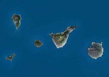
Satellite view of La Palma, Tenerife and Gran Canaria, Canary Islands, Spain. The smallest islands of La Gomera and El Hierro are also shown. This image was compiled from data acquired by Landsat 8 satellite in 2014.
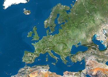
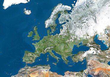
Satellite view of Europe. This image was compiled from data acquired by Landsat 7 & 8 satellites.
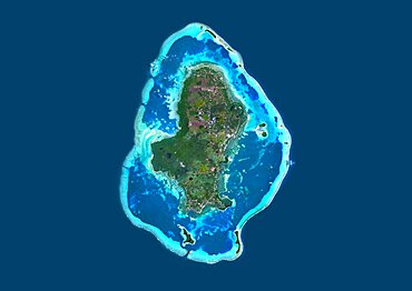
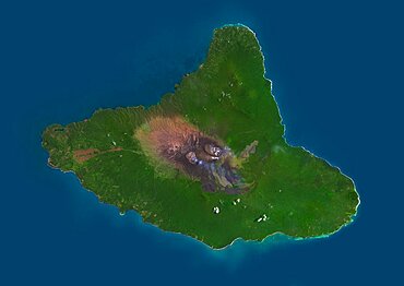
Satellite view of Hiva Oa, the second largest island in the Marquesas Islands, in French Polynesia. This image was compiled from data acquired by Landsat 8 satellite in 2014.
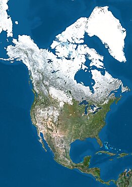
Satellite view of North America in winter, with partial snow cover. This image was compiled from data acquired by Landsat 7 & 8 satellites.
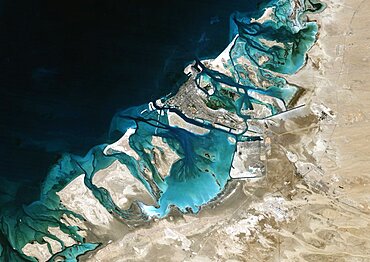
Satellite image of Abu Dhabi, United Arab Emirates, taken on February 2, 1985 by the satellite Landsat 5. The territory covered is 78 km x 55 km.
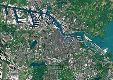
Color satellite image of Amsterdam, capital city of Netherlands. The River Amstel flows through the city. Image collected on May 26, 2017 by Sentinel-2 satellites.
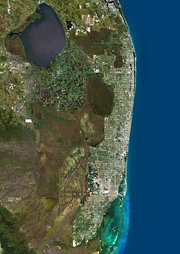
Color satellite image of Miami Metropolitan Area, Florida, United States. The Everglades natural region is at west and Biscayne National Park at south. Image collected on January 06, 2017 by Sentinel-2 satellites.

Satellite view of Africa. This image was compiled from data acquired by Landsat 7 & 8 satellites.
Colour satellite image of Phnom Penh, Cambodia. This image was taken on January 15, 2015 by Landsat 8 satellite.

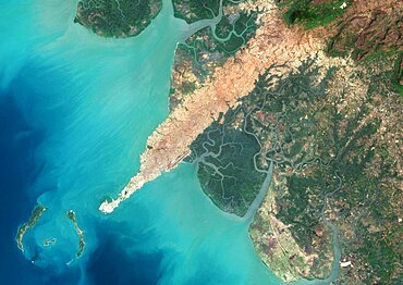
Satellite view of Adam's Bridge. This chain of limestone shoals connects Sri Lanka to India. This image was taken in 2014 by Landsat 8 satellite.
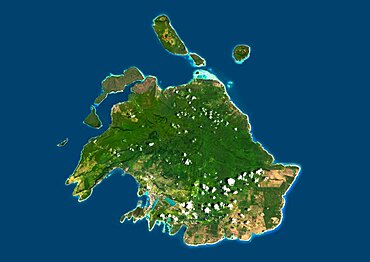
Satellite view of Efate, Vanuatu. It is the most populous island of Vanuatu archipelago. This image was compiled from data acquired by Landsat 8 satellite in 2014.
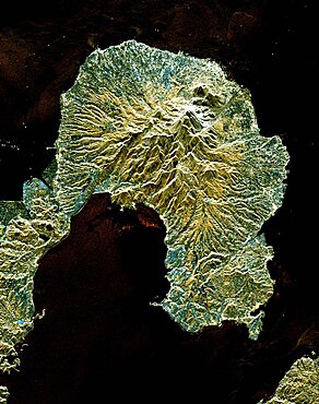
Satellite view of Ambrym, a volcanic island in the archipelago of Vanuatu. This image was compiled from data acquired by Landsat 8 satellite in 2014.
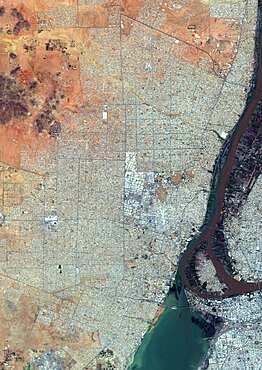
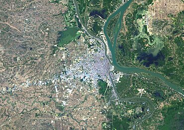
Color satellite image of Omdurman, Sudan. The city lies on the western banks of the River Nile, opposite the capital Khartoum. Image collected on October 25, 2017 by Sentinel-2 satellites.
Color satellite image of Conakry, capital city of Guinea. Image collected on March 03, 2017 by Sentinel-2 satellites.
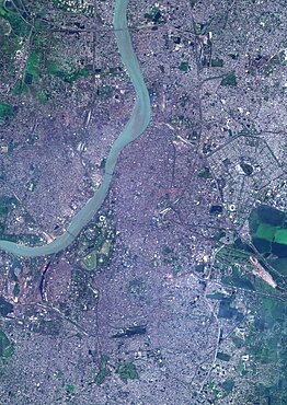
Color satellite image of Kolkata, India. The city is located on the east bank of the Hooghly River. Image collected on March 16, 2017 by Sentinel-2 satellites.
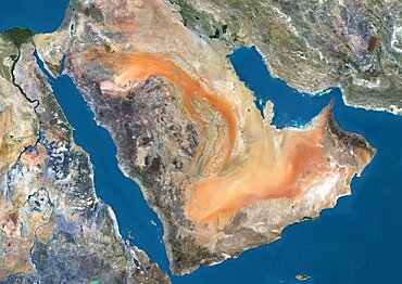
Satellite view of the Arabian Peninsula. This image was compiled from data acquired in 2014 by Landsat 8 satellite.
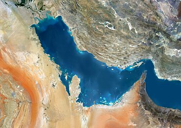
Satellite view of the Persian Gulf. This image was compiled from data acquired in 2014 by Landsat 8 satellite.
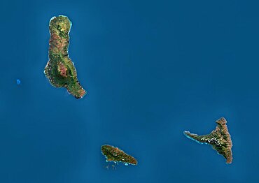
Satellite view of the Comoros Archipelago. This image was compiled from data acquired by Landsat satellites.