Results
25 results found
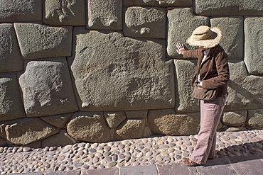
Magnificent example of Inca craftsmanship shown in this 12 sided stone, Peru, South America
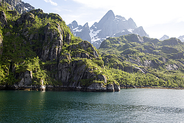
Steep sided glacial trough fiord and jagged mountain peaks, Trollfjorden, Lofoten Islands, Nordland, northern, Norway, Scandinavia, Europe

One sided penstemon (sidebells penstemon) (Penstemon secundiflorus), San Juan National Forest, Colorado, United States of America, North America
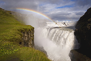
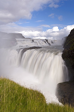
Iceland's most famous waterfall tumbles 32m into a steep sided canyon, Gullfoss, the Golden Circle, Iceland, Polar Regions
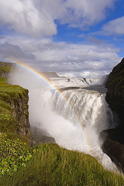
Iceland's most famous waterfall tumbles 32m into a steep sided canyon, Gullfoss, the Golden Circle, Iceland, Polar Regions
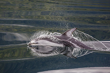
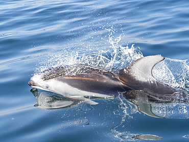
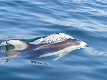
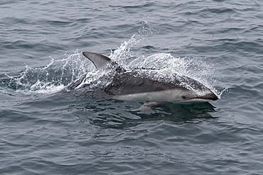
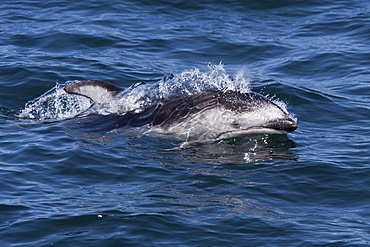
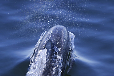
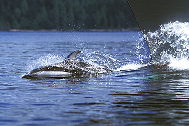
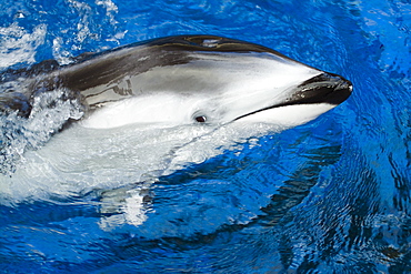
Pacific white-sided dolphin (Lagenorhynchus obliquidens), surfacing in Johnstone Strait, British Columbia, Canada, North America
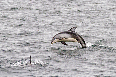
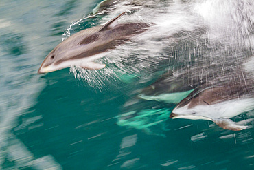
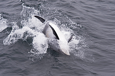
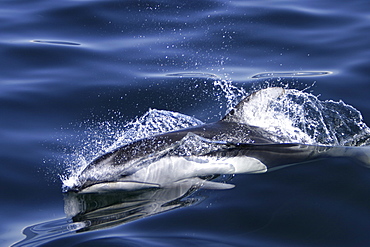
A pod of Pacific white-sided dolphins (Lagenorhynchus obliquidens) leaping and surfacing in Johnstone Strait, British Columbia, Canada, North America
A pod of Pacific white-sided dolphins (Lagenorhynchus obliquidens) leaping and surfacing in Johnstone Strait, British Columbia, Canada, North America
A pod of Pacific white-sided dolphins (Lagenorhynchus obliquidens) leaping and surfacing in Johnstone Strait, British Columbia, Canada, North America
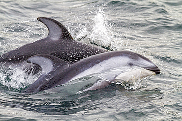
A pod of Pacific white-sided dolphins (Lagenorhynchus obliquidens) leaping and surfacing in Johnstone Strait, British Columbia, Canada, North America
A pod of Pacific white-sided dolphins (Lagenorhynchus obliquidens) leaping and surfacing in Johnstone Strait, British Columbia, Canada, North America
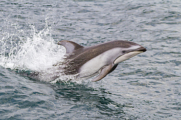
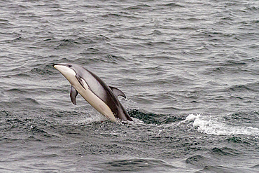
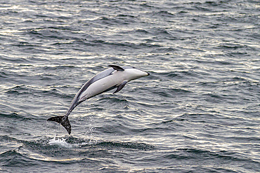
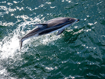
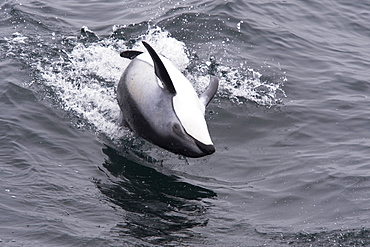
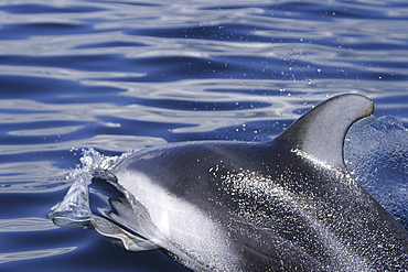
An adult Pacific white-sided dolphin (Lagenorhynchus obliquidens) leaping in Johnstone Strait, British Columbia, Canada
An adult Pacific white-sided dolphin (Lagenorhynchus obliquidens) leaping in Johnstone Strait, British Columbia, Canada
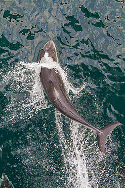
An adult Pacific white-sided dolphin (Lagenorhynchus obliquidens) leaping in Johnstone Strait, British Columbia, Canada
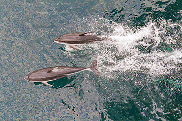
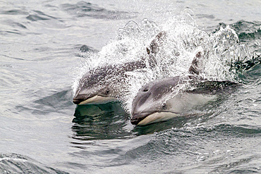
A pod of Pacific white-sided dolphins (Lagenorhynchus obliquidens) bow-riding in Johnstone Strait, British Columbia, Canada
A pod of Pacific white-sided dolphins (Lagenorhynchus obliquidens) bow-riding in Johnstone Strait, British Columbia, Canada

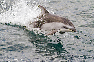
An adult Pacific white-sided dolphin (Lagenorhynchus obliquidens) bow-riding in Johnstone Strait, British Columbia, Canada
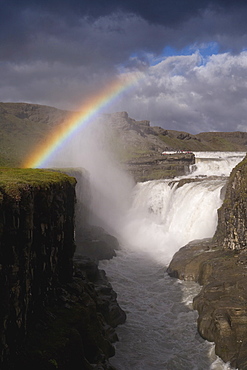
Gullfoss, Iceland's most famous waterfall tumbles 32m into a steep sided canyon, Golden Circle, Iceland, Polar Regions
Gullfoss, Iceland's most famous waterfall tumbles 32m into a steep sided canyon, Golden Circle, Iceland, Polar Regions
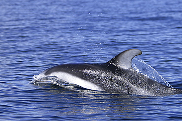
Adult Pacific white-sided dolphin (Lagenorhynchus obliquidens), in Monterey Bay, California, United States of America, North America

Adult Pacific white-sided dolphin (Lagenorhynchus obliquidens), breaching in Monterey Bay Marine Sanctuary, California, United States of America, North America
An adult Pacific white-sided dolphin (Sagmatias obliquidens), near Petersburg, Southeast Alaska, United States of America, North America
Adult Pacific white-sided dolphin (Lagenorhynchus obliquidens), in Monterey Bay, California, United States of America, North America
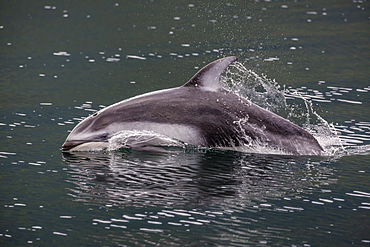
Pacific white-sided dolphin (Lagenorhynchus obliquidens), surfacing in Johnstone Strait, British Columbia, Canada, North America
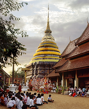
Open-sided Wihaan during the festival at Wat Phra That Luang, Lampang, Thailand, Southeast Asia, Asia
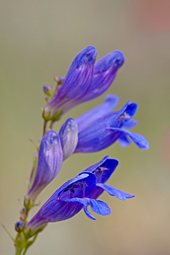
One sided penstemon (sidebells penstemon) (Penstemon secundiflorus), Gunnison National Forest, Colorado, United States of America, North America
Pacific white-sided dolphin (Lagenorhynchus obliquidens) surfacing, Monterey, California, Pacific Ocean, United States of America, North America
Pacific white-sided dolphin (Lagenorhynchus obliquidens) surfacing, Monterey, California, Pacific Ocean, United States of America, North America
Pacific white-sided dolphin (Lagenorhynchus obliquidens) unusual spinning behaviour, Monterey, California, Pacific Ocean, United States of America, North America
Pacific white-sided dolphin (Lagenorhynchus obliquidens) unusual spinning behaviour, Monterey, California, Pacific Ocean, United States of America, North America

Pacific white-sided dolphin (Lagenorhynchus obliquidens) surfacing, Monterey, California, Pacific Ocean, United States of America, North America
Adult Pacific white-sided dolphin (Lagenorhynchus obliquidens) surfacing in the calm waters of the inside passage, Southeast Alaska, USA.
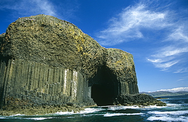
Entrance to Fingal's Cave, Staffa. Note the basalt columns which are not always six-sided. Hebrides, Scotland
Adult Pacific white-sided dolphin (Lagenorhynchus obliquidens) surfacing in the calm waters of the inside passage, Southeast Alaska, USA.
Adult Pacific white-sided dolphin (Lagenorhynchus obliquidens) surfacing in the calm waters of the inside passage, Southeast Alaska, USA.
Adult Pacific white-sided dolphin (Lagenorhynchus obliquidens) surfacing in the calm waters of the inside passage, Southeast Alaska, USA.
Adult Pacific White-sided Dolphin (Lagenorhynchus obliquidens) bow-riding in Johnstone Strait, British Columbia, Canada.
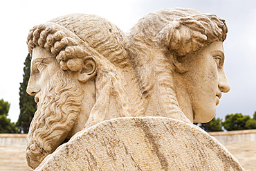
Stone heads of two sided herms inside Panathenaic Stadium, original modern day Olympic Stadium, Athens, Greece
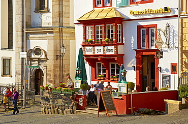
Steinernes Haus on the market square, Renaissance building with three-sided oriel window, Oldest stone built inn in Germany, Alter Markt, Hachenburg, Westerwald, Rhineland-Palatinate, Germany, Europe

Blonde woman walking through an alleyway sided with blue wooden doors, Mykonos Island, Cyclades, Greece, Europe
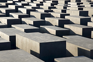
Cement squares, steles of the Holocaust Memorial, Mitte district, Berlin, Germany, Europe

Biblical depictions on the Christ side of the double-sided altar, Doberaner Muenster cathedral of Bad Doberan, Mecklenburg-Western Pomerania, Germany, Europe

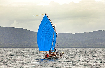
Nimoa Island - here the island mission will impress. The five-sided church features murals of island life and all mission buildings are surrounded by well maintained paths and gardens filled with flowering plants. Edged by jungle-covered mountains, postcard beaches and crystal clear waters - an island paradise indeed! The Louisiade Archipelago is a string of ten larger volcanic islands frequently fringed by coral reefs, and 90 smaller coral islands located 200 km southeast of New Guinea, stretching over more than 160 km and spread over an ocean area of 26,000 km? between the Solomon Sea to the north and the Coral Sea to the south. The aggregate land area of the islands is about 1,790 km? (690 square miles), with Vanatinai (formerly Sudest or Tagula as named by European claimants on Western maps) being the largest. Sideia Island and Basilaki Island lie closest to New Guinea, while Misima, Vanatinai, and Rossel islands lie further east. The archipelago is divided into the Local Level Government (LLG) areas Loui!

Nimoa Island - here the island mission will impress. The five-sided church features murals of island life and all mission buildings are surrounded by well maintained paths and gardens filled with flowering plants. Edged by jungle-covered mountains, postcard beaches and crystal clear waters - an island paradise indeed! The Louisiade Archipelago is a string of ten larger volcanic islands frequently fringed by coral reefs, and 90 smaller coral islands located 200 km southeast of New Guinea, stretching over more than 160 km and spread over an ocean area of 26,000 km? between the Solomon Sea to the north and the Coral Sea to the south. The aggregate land area of the islands is about 1,790 km? (690 square miles), with Vanatinai (formerly Sudest or Tagula as named by European claimants on Western maps) being the largest. Sideia Island and Basilaki Island lie closest to New Guinea, while Misima, Vanatinai, and Rossel islands lie further east. The archipelago is divided into the Local Level Government (LLG) areas Loui!

Nimoa Island - here the island mission will impress. The five-sided church features murals of island life and all mission buildings are surrounded by well maintained paths and gardens filled with flowering plants. Edged by jungle-covered mountains, postcard beaches and crystal clear waters - an island paradise indeed! The Louisiade Archipelago is a string of ten larger volcanic islands frequently fringed by coral reefs, and 90 smaller coral islands located 200 km southeast of New Guinea, stretching over more than 160 km and spread over an ocean area of 26,000 km? between the Solomon Sea to the north and the Coral Sea to the south. The aggregate land area of the islands is about 1,790 km? (690 square miles), with Vanatinai (formerly Sudest or Tagula as named by European claimants on Western maps) being the largest. Sideia Island and Basilaki Island lie closest to New Guinea, while Misima, Vanatinai, and Rossel islands lie further east. The archipelago is divided into the Local Level Government (LLG) areas Louisiade Rural (western part, with Misima), and Yaleyamba (western part, with Rossell and Tagula islands. The LLG areas are part of Samarai-Murua District district of Milne Bay. The seat of the Louisiade Rural LLG is Bwagaoia on Misima Island, the population center of the archipelago.
Nimoa Island - here the island mission will impress. The five-sided church features murals of island life and all mission buildings are surrounded by well maintained paths and gardens filled with flowering plants. Edged by jungle-covered mountains, postcard beaches and crystal clear waters - an island paradise indeed! The Louisiade Archipelago is a string of ten larger volcanic islands frequently fringed by coral reefs, and 90 smaller coral islands located 200 km southeast of New Guinea, stretching over more than 160 km and spread over an ocean area of 26,000 km? between the Solomon Sea to the north and the Coral Sea to the south. The aggregate land area of the islands is about 1,790 km? (690 square miles), with Vanatinai (formerly Sudest or Tagula as named by European claimants on Western maps) being the largest. Sideia Island and Basilaki Island lie closest to New Guinea, while Misima, Vanatinai, and Rossel islands lie further east.

Nimoa Island - here the island mission will impress. The five-sided church features murals of island life and all mission buildings are surrounded by well maintained paths and gardens filled with flowering plants. Edged by jungle-covered mountains, postcard beaches and crystal clear waters - an island paradise indeed! The Louisiade Archipelago is a string of ten larger volcanic islands frequently fringed by coral reefs, and 90 smaller coral islands located 200 km southeast of New Guinea, stretching over more than 160 km and spread over an ocean area of 26,000 km? between the Solomon Sea to the north and the Coral Sea to the south. The aggregate land area of the islands is about 1,790 km? (690 square miles), with Vanatinai (formerly Sudest or Tagula as named by European claimants on Western maps) being the largest. Sideia Island and Basilaki Island lie closest to New Guinea, while Misima, Vanatinai, and Rossel islands lie further east. The archipelago is divided into the Local Level Government (LLG) areas Louisiade Rural (western part, with Misima), and Yaleyamba (western part, with Rossell and Tagula islands. The LLG areas are part of Samarai-Murua District district of Milne Bay. The seat of the Louisiade Rural LLG is Bwagaoia on Misima Island, the population center of the archipelago.

Nimoa Island - here the island mission will impress. The five-sided church features murals of island life and all mission buildings are surrounded by well maintained paths and gardens filled with flowering plants. Edged by jungle-covered mountains, postcard beaches and crystal clear waters - an island paradise indeed! The Louisiade Archipelago is a string of ten larger volcanic islands frequently fringed by coral reefs, and 90 smaller coral islands located 200 km southeast of New Guinea, stretching over more than 160 km and spread over an ocean area of 26,000 km? between the Solomon Sea to the north and the Coral Sea to the south. The aggregate land area of the islands is about 1,790 km? (690 square miles), with Vanatinai (formerly Sudest or Tagula as named by European claimants on Western maps) being the largest. Sideia Island and Basilaki Island lie closest to New Guinea, while Misima, Vanatinai, and Rossel islands lie further east. The archipelago is divided into the Local Level Government (LLG) areas Louisiade Rural (western part, with Misima), and Yaleyamba (western part, with Rossell and Tagula islands. The LLG areas are part of Samarai-Murua District district of Milne Bay. The seat of the Louisiade Rural LLG is Bwagaoia on Misima Island, the population center of the archipelago.

Nimoa Island - here the island mission will impress. The five-sided church features murals of island life and all mission buildings are surrounded by well maintained paths and gardens filled with flowering plants. Edged by jungle-covered mountains, postcard beaches and crystal clear waters - an island paradise indeed! The Louisiade Archipelago is a string of ten larger volcanic islands frequently fringed by coral reefs, and 90 smaller coral islands located 200 km southeast of New Guinea, stretching over more than 160 km and spread over an ocean area of 26,000 km? between the Solomon Sea to the north and the Coral Sea to the south. The aggregate land area of the islands is about 1,790 km? (690 square miles), with Vanatinai (formerly Sudest or Tagula as named by European claimants on Western maps) being the largest. Sideia Island and Basilaki Island lie closest to New Guinea, while Misima, Vanatinai, and Rossel islands lie further east. The archipelago is divided into the Local Level Government (LLG) areas Loui!
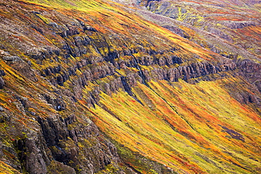
The Steep Sided Cliffs Of Icelands Westfjords Are Very Colourful In Any Season, Iceland
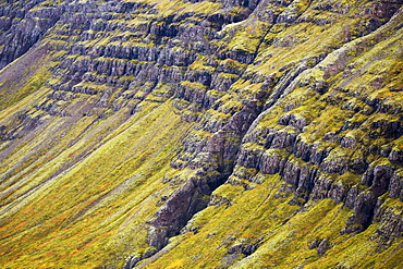
The Steep Sided Cliffs Of Icelands Westfjords Are Very Colourful In Any Season, Iceland
Canada, Pacific white-sided dolphin, Legenorhynchus obliquidens.

GHANA Ashanti Region Kumasi Busy market square with traffic crowds of people and tin roofed open sided stalls. Asante West Africa
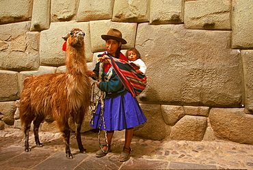
Calle Hatunrumiyoc near the Plaza de Armas contains some of the finest Inca stonework including the famous twelve sided stone, Cuzco, Highlands, Peru
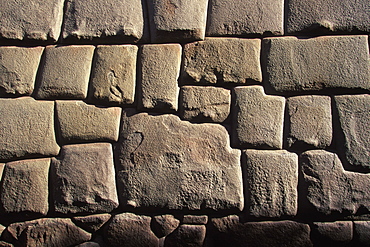
Ancient Inca capital Calle Hatunrumiyoc has the most finely constructed Inca walls including the famous twelve sided stone, Cuzco, Peru