Results
23 results found
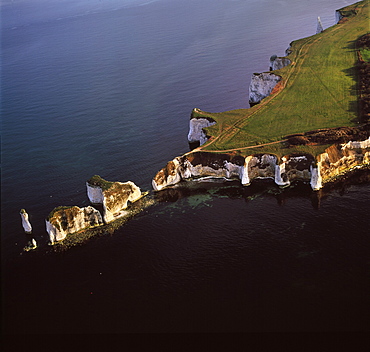
Aerial image of Old Harry Rocks, chalk stacks located directly east of Studland, north of Swanage, Dorset, England, United Kingdom, Europe
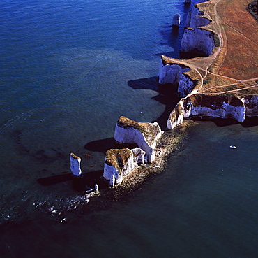
Aerial image of Old Harry Rocks, chalk stacks located directly east of Studland, north of Swanage, Dorset, England, United Kingdom, Europe
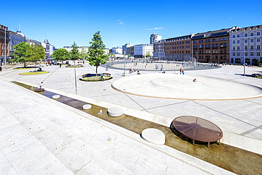
Israels Plads (Israel's Square) located in the area between Norreport station and The Lakes, Copenhagen, Denmark, Europe

Israels Plads (Israel's Square) located in the area between Norreport station and The Lakes, Copenhagen, Denmark, Europe
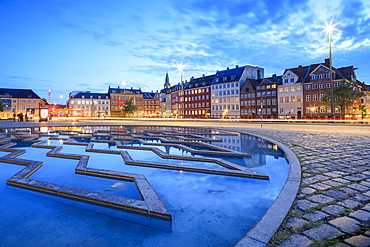
Fountain at night in Bertel Thorvaldsen's Square where Thorvaldsens Museum is located, Copenhagen, Denmark, Europe
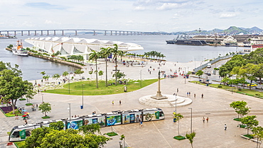
Museu do Amanha (Museum of Tomorrow) inagurated in 2014, located in Maua Square, Rio de Janeiro, Brazil, South America
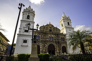
The Panama Metropolitan Cathedral in Independence Square located in the heart of the historic district in Panama City, Panama, Central America

San Jose de Cachi church located at the main square in Cachi, Salta Province, Argentina, South America
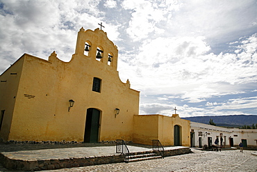
San Jose de Cachi church located at the main square in Cachi, Salta Province, Argentina, South America
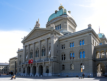
View of the central building of the Federal Palace of Switzerland, UNESCO World Heritage Site, the seat of the Swiss government, located in Bern, the federal city (Bundesstadt) and de facto capital of Switzerland, Bern, Switzerland, Europe
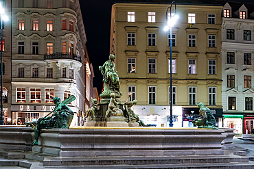
Vienna, Austria ��� View of the Donnerbrunnen, a Baroque fountain located on Neuer Markt square, featuring allegorical figures and sculpted by Georg Raphael Donner.
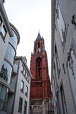
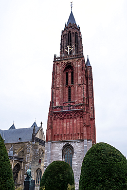
Maastricht, Netherlands dz?dz?dz? View of Sint-Janskerk, a Gothic church known for its striking red tower. Located on Vrijthof square beside the Basilica of Saint Servatius, it is a symbol of Maastrichtdz?dz?dz?s heritage.
Maastricht, Netherlands dz?dz?dz? View of Sint-Janskerk, a Gothic church known for its striking red tower. Located on Vrijthof square beside the Basilica of Saint Servatius, it is a symbol of Maastrichtdz?dz?dz?s heritage.
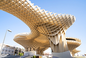
The Metropol Parasol, a wooden structure located at La Encarnacion Square, in the old quarter, Seville, Andalusia, Spain, Europe
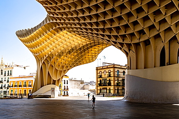
The Metropol Parasol, a wooden structure located at La Encarnacion Square, in the old quarter, Seville, Andalusia, Spain, Europe
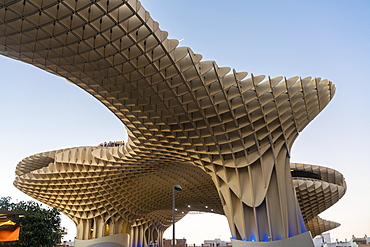
La Setas de Sevilla, Metropol Parasol is a wooden structure located at La Encarnacion square at sunset, Seville, Andalucia, Spain, Europe
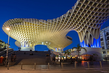
La Setas de Sevilla, Metropol Parasol is a wooden structure located at La Encarnacion square at sunset, Seville, Andalucia, Spain, Europe
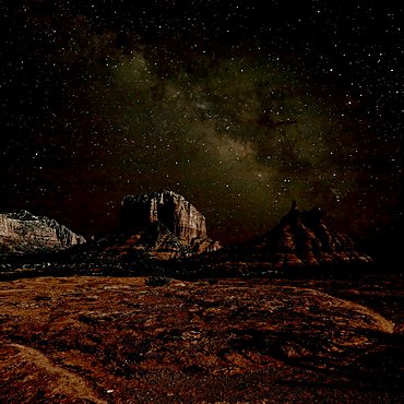
HDR composite of Bell Rock and Courthouse Butte under the Milky Way night Sky. Located in Sedona.
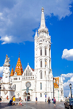
The Church of the Assumption of the Buda Castle (Matthias Church) located in the Holy Trinity Square, Budapest, Hungary, Europe
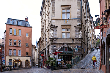
Cityscape of the Place de la Trinite, a square located in Vieux-Lyon, the city's oldest district, UNESCO World Heritage Site, Lyon, Auvergne Rhone Alpes, France, Europe
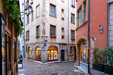
Cityscape of the Place de la Trinite, a square located in Vieux-Lyon, the city's oldest district, UNESCO World Heritage Site, Lyon, Auvergne Rhone Alpes, France, Europe
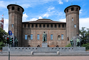
The monument to Emanuele Filiberto, Duke of D'Aosta, located in Piazza Castello, a prominent square housing several city landmarks, museums, theaters and cafes, Turin, Piedmont, Italy, Europe
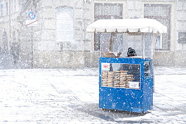
Traditional Krakow bagel seller in the snow located at the City Square, Krakow, Poland, Europe
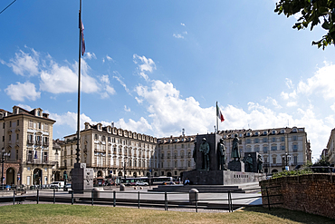
View of the monument to Emanuele Filiberto Duke of D'Aosta located in Piazza Castello, a prominent city square housing several landmarks, museums, theaters and cafes, Turin, Piedmont, Italy, Europe
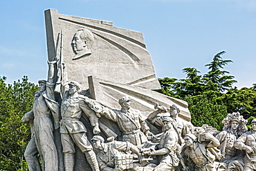
Idealized statue of socialist workers located next to Mao's Museum, Tiananmen Square, Beijing, China, Asia
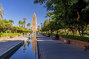
The Kutubiyya Mosque is the largest mosque in Marrakesh, Morocco. Located in the southwest medina quarter of Marrakesh, near the famous public place of Jemaa el-Fna
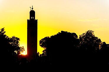
November 13, 2021, Medina, Marrakesh, MAR: The Kutubiyya Mosque is the largest mosque in Marrakesh, Morocco. It is located in the southwest medina quarter of Marrakesh, near the famous public place of Jemaa el-Fna
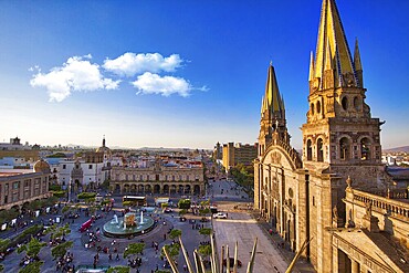
Guadalajara, Jalisc, Mexico-20 April, 2018: Central Landmark Cathedral (Cathedral of the Assumption of Our Lady) located on the central plaza of Guadalajara
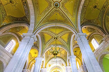
Victoria de Durango, Durango, Mexico, 10 September, 2021: Catholic church of Cathedral Basilica of Durango in colonial historic city center located opposite Durango central square Plaza de Armas, Central America
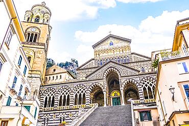
Beautiful Amalfi Cathedral located in in the Piazza del Duomo, Amalfi, Italy, Europe
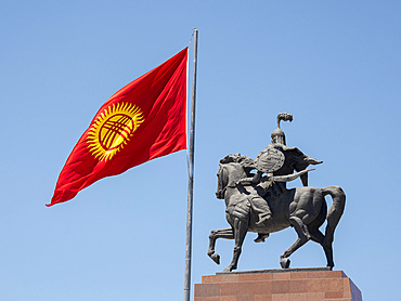
Monument of the national hero Manas "Aykol Manas" by Bazarbai Sydykov. Ala Too square in the city center. The capital Bishkek located in the foothills of Tien Shan. Asia, Central asia, Kyrgyzstan
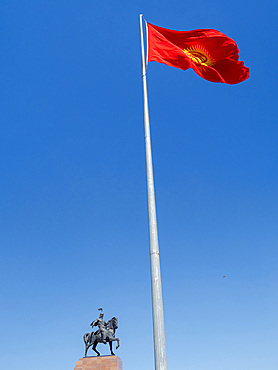
Monument of the national hero Manas "Aykol Manas" by Bazarbai Sydykov. Ala Too square in the city center. The capital Bishkek located in the foothills of Tien Shan. Asia, Central asia, Kyrgyzstan
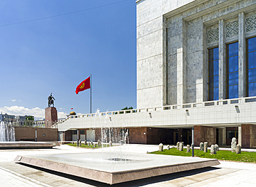
National Museum . Ala Too square in the city center. The capital Bishkek located in the foothills of Tien Shan. Asia, Central asia, Kyrgyzstan
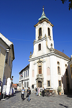
Szentendre near Budapest. Main Square (foe ter) and the Blagovescenska church Szentendre, which calls itself the town of artists and churches, is located on the banks of river Danube close to Budapest and is one of the major attractions in Hungary. The little lanes, the museums and churches and the buildings in rococo and baroque styles are creating an atmosphere dating back to the Austro-Hungarian Monarchy. Europe, Eastern Europe, Pest, Szentendre
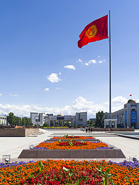
Ala Too square in the city center. The capital Bishkek located in the foothills of Tien Shan. Asia, Central asia, Kyrgyzstan
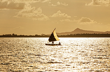
The Louisiade Archipelago is a string of ten larger volcanic islands frequently fringed by coral reefs, and 90 smaller coral islands located 200 km southeast of New Guinea, stretching over more than 160 km and spread over an ocean area of 26,000 km? between the Solomon Sea to the north and the Coral Sea to the south. The aggregate land area of the islands is about 1,790 km? (690 square miles), with Vanatinai (formerly Sudest or Tagula as named by European claimants on Western maps) being the largest.Sideia Island and Basilaki Island lie closest to New Guinea, while Misima, Vanatinai, and Rossel islands lie further east. The archipelago is divided into the Local Level Government (LLG) areas Louisiade Rural (western part, with Misima), and Yaleyamba (western part, with Rossell and Tagula islands. The LLG areas are part of Samarai-Murua District district of Milne Bay. The seat of the Louisiade Rural LLG is Bwagaoia on Misima Island, the population center of the archipelago.
The Louisiade Archipelago is a string of ten larger volcanic islands frequently fringed by coral reefs, and 90 smaller coral islands located 200 km southeast of New Guinea, stretching over more than 160 km and spread over an ocean area of 26,000 km? between the Solomon Sea to the north and the Coral Sea to the south. The aggregate land area of the islands is about 1,790 km? (690 square miles), with Vanatinai (formerly Sudest or Tagula as named by European claimants on Western maps) being the largest. Sideia Island and Basilaki Island lie closest to New Guinea, while Misima, Vanatinai, and Rossel islands lie further east. The archipelago is divided into the Local Level Government (LLG) areas Louisiade Rural (western part, with Misima), and Yaleyamba (western part, with Rossell and Tagula islands. The LLG areas are part of Samarai-Murua District district of Milne Bay. The seat of the Louisiade Rural LLG is Bwagaoia on Misima Island, the population center of the archipelago.

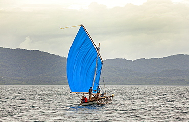
Nimoa Island - here the island mission will impress. The five-sided church features murals of island life and all mission buildings are surrounded by well maintained paths and gardens filled with flowering plants. Edged by jungle-covered mountains, postcard beaches and crystal clear waters - an island paradise indeed! The Louisiade Archipelago is a string of ten larger volcanic islands frequently fringed by coral reefs, and 90 smaller coral islands located 200 km southeast of New Guinea, stretching over more than 160 km and spread over an ocean area of 26,000 km? between the Solomon Sea to the north and the Coral Sea to the south. The aggregate land area of the islands is about 1,790 km? (690 square miles), with Vanatinai (formerly Sudest or Tagula as named by European claimants on Western maps) being the largest. Sideia Island and Basilaki Island lie closest to New Guinea, while Misima, Vanatinai, and Rossel islands lie further east. The archipelago is divided into the Local Level Government (LLG) areas Loui!

Nimoa Island - here the island mission will impress. The five-sided church features murals of island life and all mission buildings are surrounded by well maintained paths and gardens filled with flowering plants. Edged by jungle-covered mountains, postcard beaches and crystal clear waters - an island paradise indeed! The Louisiade Archipelago is a string of ten larger volcanic islands frequently fringed by coral reefs, and 90 smaller coral islands located 200 km southeast of New Guinea, stretching over more than 160 km and spread over an ocean area of 26,000 km? between the Solomon Sea to the north and the Coral Sea to the south. The aggregate land area of the islands is about 1,790 km? (690 square miles), with Vanatinai (formerly Sudest or Tagula as named by European claimants on Western maps) being the largest. Sideia Island and Basilaki Island lie closest to New Guinea, while Misima, Vanatinai, and Rossel islands lie further east. The archipelago is divided into the Local Level Government (LLG) areas Loui!

Nimoa Island - here the island mission will impress. The five-sided church features murals of island life and all mission buildings are surrounded by well maintained paths and gardens filled with flowering plants. Edged by jungle-covered mountains, postcard beaches and crystal clear waters - an island paradise indeed! The Louisiade Archipelago is a string of ten larger volcanic islands frequently fringed by coral reefs, and 90 smaller coral islands located 200 km southeast of New Guinea, stretching over more than 160 km and spread over an ocean area of 26,000 km? between the Solomon Sea to the north and the Coral Sea to the south. The aggregate land area of the islands is about 1,790 km? (690 square miles), with Vanatinai (formerly Sudest or Tagula as named by European claimants on Western maps) being the largest. Sideia Island and Basilaki Island lie closest to New Guinea, while Misima, Vanatinai, and Rossel islands lie further east. The archipelago is divided into the Local Level Government (LLG) areas Louisiade Rural (western part, with Misima), and Yaleyamba (western part, with Rossell and Tagula islands. The LLG areas are part of Samarai-Murua District district of Milne Bay. The seat of the Louisiade Rural LLG is Bwagaoia on Misima Island, the population center of the archipelago.
Nimoa Island - here the island mission will impress. The five-sided church features murals of island life and all mission buildings are surrounded by well maintained paths and gardens filled with flowering plants. Edged by jungle-covered mountains, postcard beaches and crystal clear waters - an island paradise indeed! The Louisiade Archipelago is a string of ten larger volcanic islands frequently fringed by coral reefs, and 90 smaller coral islands located 200 km southeast of New Guinea, stretching over more than 160 km and spread over an ocean area of 26,000 km? between the Solomon Sea to the north and the Coral Sea to the south. The aggregate land area of the islands is about 1,790 km? (690 square miles), with Vanatinai (formerly Sudest or Tagula as named by European claimants on Western maps) being the largest. Sideia Island and Basilaki Island lie closest to New Guinea, while Misima, Vanatinai, and Rossel islands lie further east.
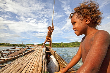
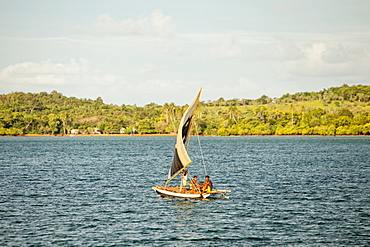
Children playing with a outrigger canoe in the village of Hessessai Bay at PanaTinai (Panatinane)island in the Louisiade Archipelago in Milne Bay Province, Papua New Guinea. The island has an area of 78 km2. The Louisiade Archipelago is a string of ten larger volcanic islands frequently fringed by coral reefs, and 90 smaller coral islands located 200 km southeast of New Guinea, stretching over more than 160 km and spread over an ocean area of 26,000 km? between the Solomon Sea to the north and the Coral Sea to the south. The aggregate land area of the islands is about 1,790 km? (690 square miles), with Vanatinai (formerly Sudest or Tagula as named by European claimants on Western maps) being the largest. Sideia Island and Basilaki Island lie closest to New Guinea, while Misima, Vanatinai, and Rossel islands lie further east. The archipelago is divided into the Local Level Government (LLG) areas Louisiade Rural (western part, with Misima), and Yaleyamba (western part, with Rossell and Tagula islands. The LLG areas are part of Samarai-Murua District district of Milne Bay. The seat of the Louisiade Rural LLG is Bwagaoia on Misima Island, the population center of the archipelago.PanaTinai (Panatinane) is an island in the Louisiade Archipelago in Milne Bay Province, Papua New Guinea.

Nimoa Island - here the island mission will impress. The five-sided church features murals of island life and all mission buildings are surrounded by well maintained paths and gardens filled with flowering plants. Edged by jungle-covered mountains, postcard beaches and crystal clear waters - an island paradise indeed! The Louisiade Archipelago is a string of ten larger volcanic islands frequently fringed by coral reefs, and 90 smaller coral islands located 200 km southeast of New Guinea, stretching over more than 160 km and spread over an ocean area of 26,000 km? between the Solomon Sea to the north and the Coral Sea to the south. The aggregate land area of the islands is about 1,790 km? (690 square miles), with Vanatinai (formerly Sudest or Tagula as named by European claimants on Western maps) being the largest. Sideia Island and Basilaki Island lie closest to New Guinea, while Misima, Vanatinai, and Rossel islands lie further east. The archipelago is divided into the Local Level Government (LLG) areas Louisiade Rural (western part, with Misima), and Yaleyamba (western part, with Rossell and Tagula islands. The LLG areas are part of Samarai-Murua District district of Milne Bay. The seat of the Louisiade Rural LLG is Bwagaoia on Misima Island, the population center of the archipelago.

Nimoa Island - here the island mission will impress. The five-sided church features murals of island life and all mission buildings are surrounded by well maintained paths and gardens filled with flowering plants. Edged by jungle-covered mountains, postcard beaches and crystal clear waters - an island paradise indeed! The Louisiade Archipelago is a string of ten larger volcanic islands frequently fringed by coral reefs, and 90 smaller coral islands located 200 km southeast of New Guinea, stretching over more than 160 km and spread over an ocean area of 26,000 km? between the Solomon Sea to the north and the Coral Sea to the south. The aggregate land area of the islands is about 1,790 km? (690 square miles), with Vanatinai (formerly Sudest or Tagula as named by European claimants on Western maps) being the largest. Sideia Island and Basilaki Island lie closest to New Guinea, while Misima, Vanatinai, and Rossel islands lie further east. The archipelago is divided into the Local Level Government (LLG) areas Louisiade Rural (western part, with Misima), and Yaleyamba (western part, with Rossell and Tagula islands. The LLG areas are part of Samarai-Murua District district of Milne Bay. The seat of the Louisiade Rural LLG is Bwagaoia on Misima Island, the population center of the archipelago.

Nimoa Island - here the island mission will impress. The five-sided church features murals of island life and all mission buildings are surrounded by well maintained paths and gardens filled with flowering plants. Edged by jungle-covered mountains, postcard beaches and crystal clear waters - an island paradise indeed! The Louisiade Archipelago is a string of ten larger volcanic islands frequently fringed by coral reefs, and 90 smaller coral islands located 200 km southeast of New Guinea, stretching over more than 160 km and spread over an ocean area of 26,000 km? between the Solomon Sea to the north and the Coral Sea to the south. The aggregate land area of the islands is about 1,790 km? (690 square miles), with Vanatinai (formerly Sudest or Tagula as named by European claimants on Western maps) being the largest. Sideia Island and Basilaki Island lie closest to New Guinea, while Misima, Vanatinai, and Rossel islands lie further east. The archipelago is divided into the Local Level Government (LLG) areas Loui!

Quartier de la Sorbonne is 20th administrative district or quartier of Paris, France. It is located in 5th arrondissement of Paris, near jardin du Luxembourg and Sorbonne, on Montagne Sainte-Genevieve, Paris, Ile-de-France, France