Results
62 results found
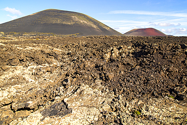
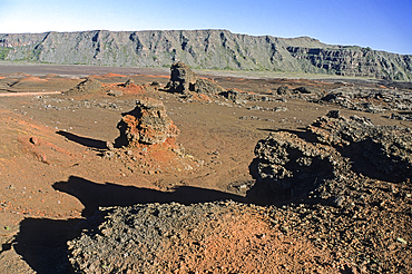
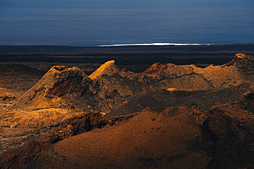
Malpais badlands volcanic landscape Montana Negra and Caldera Colorada, Parque Natural Los Volcanes, Masdache, Lanzarote, Canary islands, Spain, Atlantic, Europe
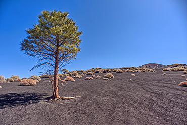
Lone Pine Tree, Coconino National Forest, Arizona, USA
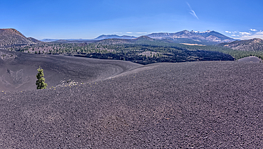
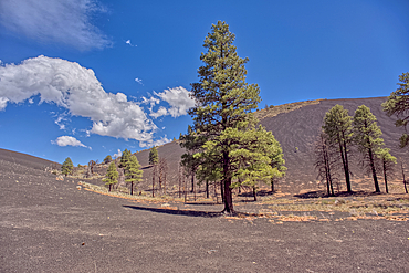
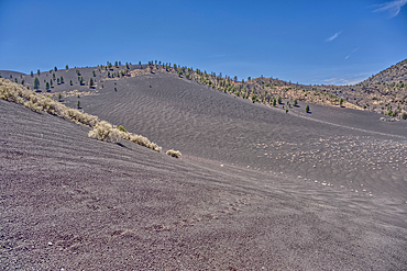
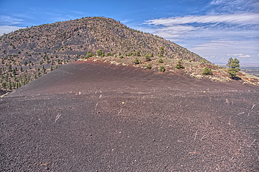
Volcanic cinder rim in Coconino National Forest, Arizona, USA
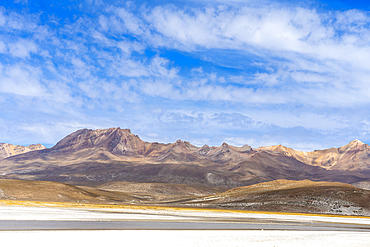
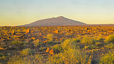
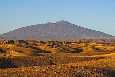
Pichu Pichu volcano (Picchu Picchu) seen from salt flats of Salinas y Aguada Blanca National Reserve, Arequipa Region, Peru, South America
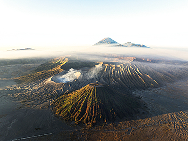
Volcanoes at sunrise, Bromo Tengger Semeru National Park, East Java, Indonesia
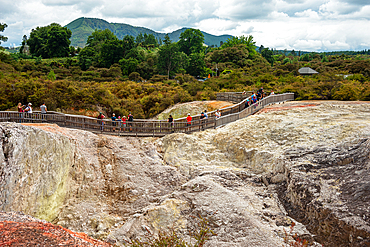
Walking paths through a volcano landscape in Waiotapu Thermal Wonderland, North Island, New Zealand
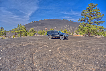
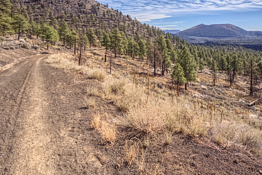
An SUV traveling near Volcanic cinder hills in Coconino National Forest, Arizona, USA
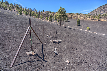
Volcanic cinder hills in Coconino National Forest, Arizona, USA
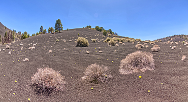
Volcanic cinder hills in Coconino National Forest, Arizona, USA
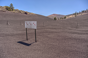
The boundary fence between Coconino National Forest and Sunset Crater National Monument of Arizona, USA
The boundary fence between Coconino National Forest and Sunset Crater National Monument of Arizona.
Volcanic cinder hills in Coconino National Forest, Arizona, USA
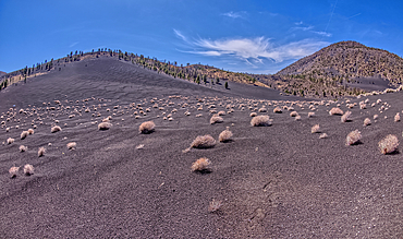
Volcanic cinder hills in Coconino National Forest, Arizona, USA

View from summit of Pico do Areeiro, Madeira
Sunset Crater Volcano viewed from the forested slope of O'Leary Peak in northern Arizona.
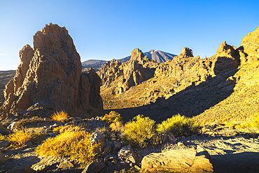
Teide volcano from La Ruleta viewpoint during sunset, Teide National Park, La Orotava, Santa Cruz de Tenerife, Tenerife, Canary Islands, Macaronesia, Spain, Western Europe
O'Leary Peak, Coconino National Forest, Arizona, USA
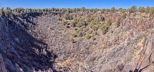
The giant sinkhole known as Johnson Crater in the Kaibab National Forest near Ash Fork Arizona, USA
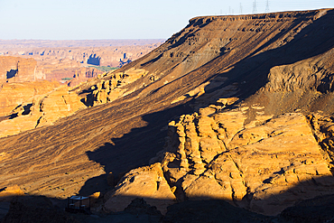
Mountainscape viewed from the top of Harrat volcanic plateau, AlUla, Medina Province, Saudi Arabia
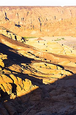
Mountainscape viewed from the top of Harrat volcanic plateau, AlUla, Medina Province, Saudi Arabia
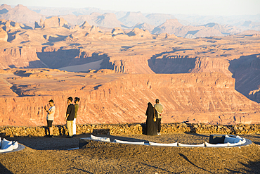
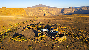
People at the Viewpoint on the Harrat volcanic plateau, AlUla, Medina Province, Saudi Arabia
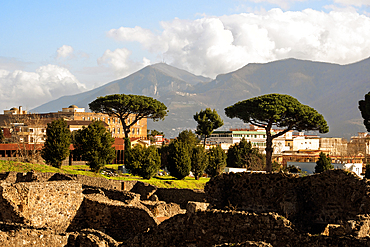
The archaeological ruins of Pompeii with Mount Vesuvius in the background, UNESCO, Campania, Italy
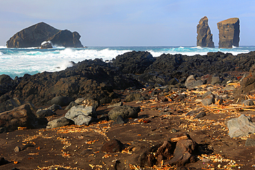
Mosteiros and coast, Sao Miguel, Azores Islands, Atlantic, Portugal
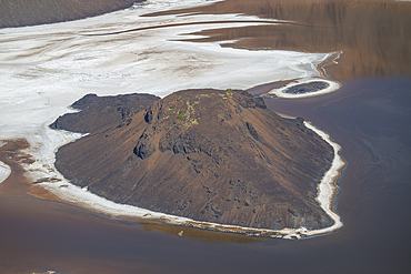
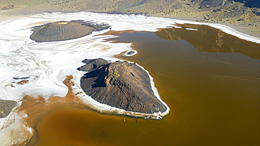
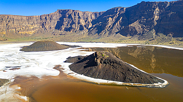
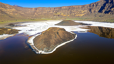
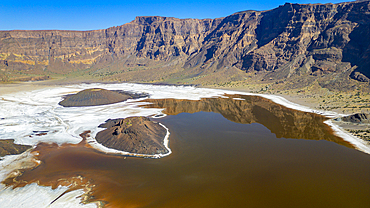
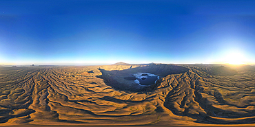
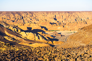
Aerial of the Trou du Natron volcanic crater and its natron lakes, Tibesti Mountains, Chad
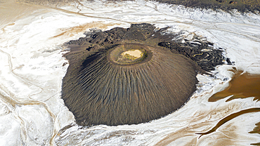
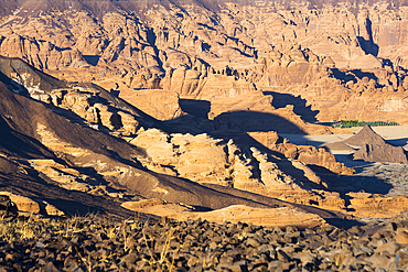
Tousside volcano above Trou du Natron, Tibesti Mountains, Chad
Aerial of the Trou du Natron volcanic crater and its natron lakes, Tibesti Mountains, Chad
Aerial of the Trou du Natron volcanic crater and its natron lakes, Tibesti Mountains, Chad
Aerial of the Trou du Natron volcanic crater and its natron lakes, Tibesti Mountains, Chad
Aerial of the Trou du Natron volcanic crater and its natron lakes, Tibesti Mountains, Chad
Aerial over Trou du Natron with volcano Tousside in the background, Tibesti Mountains, Chad
Aerial over Trou du Natron with volcano Tousside in the background, Tibesti Mountains, Chad
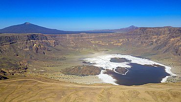
Aerial of the Trou du Natron volcanic crater and its natron lakes, Tibesti Mountains, Chad
Aerial of the Trou du Natron volcanic crater and its natron lakes, Tibesti Mountains, Chad
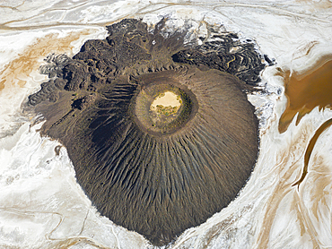
Aerial of the Trou du Natron volcanic crater and its natron lakes, Tibesti Mountains, Chad
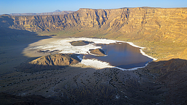
Aerial of the Trou du Natron volcanic crater and its natron lakes, Tibesti Mountains, Chad
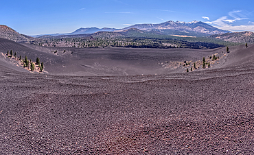
Volcanic cinder rim in Coconino National Forest, Arizona, USA
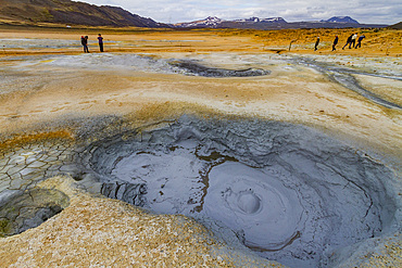
A view of the boiling mud at Namafjall, Iceland
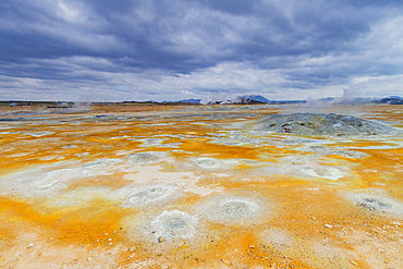
A view of the boiling mud at Namafjall, Iceland
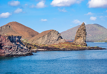
Pinnacle Rock, a volcanic plug on Bartolome Island, one of the most spectacular features of the Galapagos islands, UNESCO World Heritage Site, Ecuador, South America
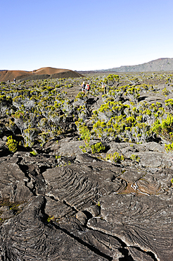
Hikers inside the caldera Enclos Fouque, Piton de la Fournaise, Reunion
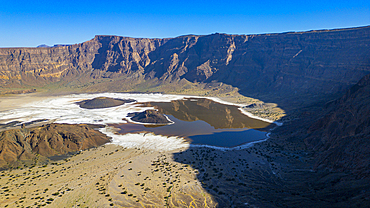
Aerial of the Trou du Natron volcanic crater and its natron lakes, Tibesti Mountains, Chad
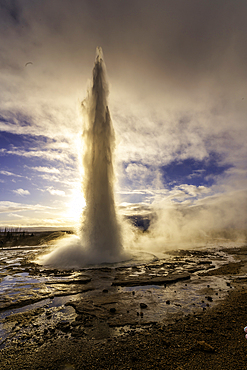
View of geysers at Geysir Hot Springs in winter, Western Region, Iceland
Continental drift between North American and Eurasian tectonic plates, Thingvellir National Park, UNESCO, in winter, Western Region, Iceland
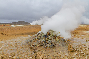
A view of the boiling mud at Namafjall, Iceland

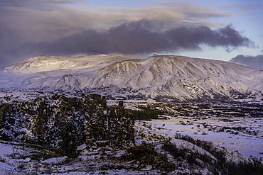
Eystrahorn mountain, South Iceland, Iceland, Europe
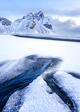
View of the mountains of Vestrahorn from black volcanic sand beach after snowfall, Stokksnes, South Iceland, Iceland, Polar Regions
Piton de la Fournaise volcano, Reunion
Mountainscape viewed from the top of Harrat volcanic plateau, AlUla, Medina Province, Saudi Arabia
Mountainscape viewed from the top of Harrat volcanic plateau, AlUla, Medina Province, Saudi Arabia
Tousside volcano above Trou du Natron, Tibesti Mountains, Chad

Volcanic scenery in the valley of Alto Mira, northwest Saint Anthony, Cape Verde

Volcanic scenery in the valley of Alto Mira, northwest Saint Anthony, Cape Verde

Volcanic scenery in the valley of Alto Mira, northwest Saint Anthony, Cape Verde

Volcanic scenery in the valley of Alto Mira, northwest Saint Anthony, Cape Verde

The spectacular scenery of the north coast and volcanic highlands of Saint Anthony, Cape Verde

The spectacular scenery of the north coast and volcanic highlands of Saint Anthony, Cape Verde

The dramatic scenery in the volcanic highlands of northern Saint Anthony, Cape Verde

The dramatic scenery in the volcanic highlands of northern Saint Anthony, Cape Verde
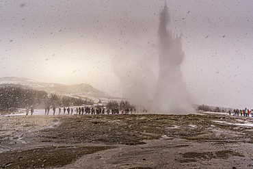
View of geysers at Geysir Hot Springs in winter, Western Region, Iceland
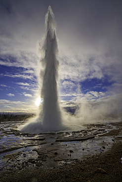
View of geysers at Geysir Hot Springs in winter, Western Region, Iceland
view of Volcanoes and the Volcanic landscape with the Atlantic Ocean in the Timanfaya national park in Lanzarote in the Canary Islands, Spain
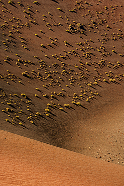
Volcanic landscape with small plants in the Timanfaya national park in Lanzarote in the Canary Islands, Spain
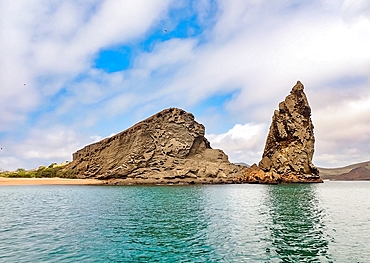
Pinnacle Rock, a volcanic plug on Bartolome Island, one of the most spectacular features of the Galapagos Islands, UNESCO World Heritage Site, Ecuador, South America
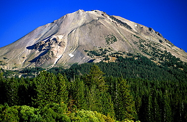
Dormant 10,457ft Lassen Peak, the world's largest plug-dome volcano, in Lassen Volcanic National Park, an area of volcanic activity and features, Lassen Volcanic Park, Northern California, California, United States of America (USA), North America

Looking south towards Lake Helen from dormant 10,457ft Lassen Peak, the world's largest plug-dome volcano, in Lassen Volcanic National Park, an area of volcanic activities and features, Lassen Volcanic Park, Northern California, California, United States of America (USA), North America

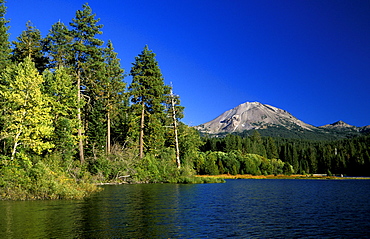
Lake Helen and the dormant 10,457ft Lassen Peak, the world's largest plug-dome volcano, in Lassen Volcanic National Park, an area of volcanic activities and features, Lassen Volcanic Park, Northern California, California, USA
Manzanita Lake and the dormant 10,457ft Lassen Peak, the world's largest plug-dome volcano, in Lassen Volcanic National Park, an area of volcanic activities and features, Lassen Volcanic Park, Northern California, California, United States of America (USA), North America

Lake Helen and the dormant 10,457ft Lassen Peak, the world's largest plug-dome volcano, in Lassen Volcanic National Park, an area of volcanic activities and features, Lassen Volcanic Park, Northern California, California, USA

Fir trees in the south west of Lassen Volcanic National Park, an area of volcanic activities and features, Lassen Volcanic National Park, Northern California, California, United States of America (USA), North America
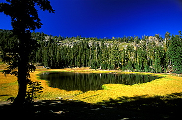
'Cold Boiling Lake' in Lassen Volcanic National Park, Northern California, Usaan area of volcanic activities and features around Lassen Peak volcano

Nimoa Island - here the island mission will impress. The five-sided church features murals of island life and all mission buildings are surrounded by well maintained paths and gardens filled with flowering plants. Edged by jungle-covered mountains, postcard beaches and crystal clear waters - an island paradise indeed! The Louisiade Archipelago is a string of ten larger volcanic islands frequently fringed by coral reefs, and 90 smaller coral islands located 200 km southeast of New Guinea, stretching over more than 160 km and spread over an ocean area of 26,000 km? between the Solomon Sea to the north and the Coral Sea to the south. The aggregate land area of the islands is about 1,790 km? (690 square miles), with Vanatinai (formerly Sudest or Tagula as named by European claimants on Western maps) being the largest. Sideia Island and Basilaki Island lie closest to New Guinea, while Misima, Vanatinai, and Rossel islands lie further east. The archipelago is divided into the Local Level Government (LLG) areas Loui!

Nimoa Island - here the island mission will impress. The five-sided church features murals of island life and all mission buildings are surrounded by well maintained paths and gardens filled with flowering plants. Edged by jungle-covered mountains, postcard beaches and crystal clear waters - an island paradise indeed! The Louisiade Archipelago is a string of ten larger volcanic islands frequently fringed by coral reefs, and 90 smaller coral islands located 200 km southeast of New Guinea, stretching over more than 160 km and spread over an ocean area of 26,000 km? between the Solomon Sea to the north and the Coral Sea to the south. The aggregate land area of the islands is about 1,790 km? (690 square miles), with Vanatinai (formerly Sudest or Tagula as named by European claimants on Western maps) being the largest. Sideia Island and Basilaki Island lie closest to New Guinea, while Misima, Vanatinai, and Rossel islands lie further east. The archipelago is divided into the Local Level Government (LLG) areas Loui!

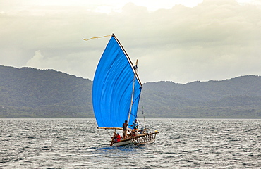
Nimoa Island - here the island mission will impress. The five-sided church features murals of island life and all mission buildings are surrounded by well maintained paths and gardens filled with flowering plants. Edged by jungle-covered mountains, postcard beaches and crystal clear waters - an island paradise indeed! The Louisiade Archipelago is a string of ten larger volcanic islands frequently fringed by coral reefs, and 90 smaller coral islands located 200 km southeast of New Guinea, stretching over more than 160 km and spread over an ocean area of 26,000 km? between the Solomon Sea to the north and the Coral Sea to the south. The aggregate land area of the islands is about 1,790 km? (690 square miles), with Vanatinai (formerly Sudest or Tagula as named by European claimants on Western maps) being the largest. Sideia Island and Basilaki Island lie closest to New Guinea, while Misima, Vanatinai, and Rossel islands lie further east. The archipelago is divided into the Local Level Government (LLG) areas Louisiade Rural (western part, with Misima), and Yaleyamba (western part, with Rossell and Tagula islands. The LLG areas are part of Samarai-Murua District district of Milne Bay. The seat of the Louisiade Rural LLG is Bwagaoia on Misima Island, the population center of the archipelago.
Nimoa Island - here the island mission will impress. The five-sided church features murals of island life and all mission buildings are surrounded by well maintained paths and gardens filled with flowering plants. Edged by jungle-covered mountains, postcard beaches and crystal clear waters - an island paradise indeed! The Louisiade Archipelago is a string of ten larger volcanic islands frequently fringed by coral reefs, and 90 smaller coral islands located 200 km southeast of New Guinea, stretching over more than 160 km and spread over an ocean area of 26,000 km? between the Solomon Sea to the north and the Coral Sea to the south. The aggregate land area of the islands is about 1,790 km? (690 square miles), with Vanatinai (formerly Sudest or Tagula as named by European claimants on Western maps) being the largest. Sideia Island and Basilaki Island lie closest to New Guinea, while Misima, Vanatinai, and Rossel islands lie further east.

Nimoa Island - here the island mission will impress. The five-sided church features murals of island life and all mission buildings are surrounded by well maintained paths and gardens filled with flowering plants. Edged by jungle-covered mountains, postcard beaches and crystal clear waters - an island paradise indeed! The Louisiade Archipelago is a string of ten larger volcanic islands frequently fringed by coral reefs, and 90 smaller coral islands located 200 km southeast of New Guinea, stretching over more than 160 km and spread over an ocean area of 26,000 km? between the Solomon Sea to the north and the Coral Sea to the south. The aggregate land area of the islands is about 1,790 km? (690 square miles), with Vanatinai (formerly Sudest or Tagula as named by European claimants on Western maps) being the largest. Sideia Island and Basilaki Island lie closest to New Guinea, while Misima, Vanatinai, and Rossel islands lie further east. The archipelago is divided into the Local Level Government (LLG) areas Louisiade Rural (western part, with Misima), and Yaleyamba (western part, with Rossell and Tagula islands. The LLG areas are part of Samarai-Murua District district of Milne Bay. The seat of the Louisiade Rural LLG is Bwagaoia on Misima Island, the population center of the archipelago.

Nimoa Island - here the island mission will impress. The five-sided church features murals of island life and all mission buildings are surrounded by well maintained paths and gardens filled with flowering plants. Edged by jungle-covered mountains, postcard beaches and crystal clear waters - an island paradise indeed! The Louisiade Archipelago is a string of ten larger volcanic islands frequently fringed by coral reefs, and 90 smaller coral islands located 200 km southeast of New Guinea, stretching over more than 160 km and spread over an ocean area of 26,000 km? between the Solomon Sea to the north and the Coral Sea to the south. The aggregate land area of the islands is about 1,790 km? (690 square miles), with Vanatinai (formerly Sudest or Tagula as named by European claimants on Western maps) being the largest. Sideia Island and Basilaki Island lie closest to New Guinea, while Misima, Vanatinai, and Rossel islands lie further east. The archipelago is divided into the Local Level Government (LLG) areas Louisiade Rural (western part, with Misima), and Yaleyamba (western part, with Rossell and Tagula islands. The LLG areas are part of Samarai-Murua District district of Milne Bay. The seat of the Louisiade Rural LLG is Bwagaoia on Misima Island, the population center of the archipelago.

Nimoa Island - here the island mission will impress. The five-sided church features murals of island life and all mission buildings are surrounded by well maintained paths and gardens filled with flowering plants. Edged by jungle-covered mountains, postcard beaches and crystal clear waters - an island paradise indeed! The Louisiade Archipelago is a string of ten larger volcanic islands frequently fringed by coral reefs, and 90 smaller coral islands located 200 km southeast of New Guinea, stretching over more than 160 km and spread over an ocean area of 26,000 km? between the Solomon Sea to the north and the Coral Sea to the south. The aggregate land area of the islands is about 1,790 km? (690 square miles), with Vanatinai (formerly Sudest or Tagula as named by European claimants on Western maps) being the largest. Sideia Island and Basilaki Island lie closest to New Guinea, while Misima, Vanatinai, and Rossel islands lie further east. The archipelago is divided into the Local Level Government (LLG) areas Loui!

Volcanic Activity