Results
2 results found
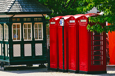
A charming scene featuring three iconic red telephone booths next to a vintage green kiosk. The booths are bright and well-maintained, surrounded by lush greenery and a hint of urban life.
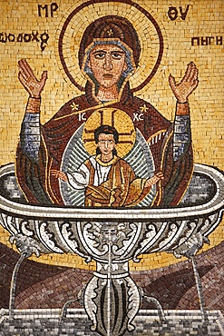
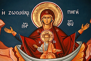
Greek Orthodox icon depicting Mary as a well of life, St. George's Orthodox church, Madaba, Jordan, Middle East
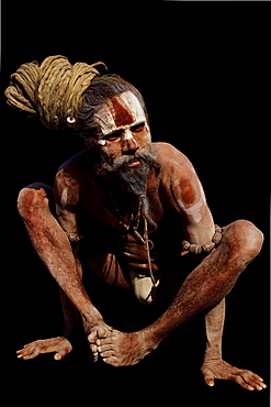
Aside from a life of simplicity focus on divine, many sadhus engage in a diverse array of practices both internal external in order to attain higher states of awareness consciousness. This sadhu chosen hatha yoga shows results--a well-disciplined, strong body--while holding kukkuta asana, or cock posture. India
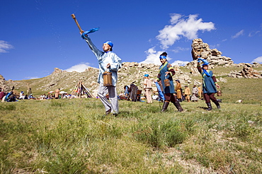
Horse milk is sprinkled into the four directions, as offerings to the nature spirits of the area, the sadak, or ?owners Of the earth.? Sometimes vodka is used instead, or as well. Milk is sacred to the mongol shamans, who believe that life on earth is descended from beings who originally came here on winged horses. Here two young female shamans make the offering in a ritual manner. Countryside mongols make this offering every morning on waking up; they usually also offer smoke, that the wind carries around the world as a prayer for harmony and prosperity. 13th century national park, tov province, mongolia. 13th century national park comprises chinggis khan's giant statue museum and live museum "town from 13 century". The ancient nomadic mini kingdom is located in the distance of 130 km east of ulaanbaatar in area of erdene zuu of tov province. It takes 2 hours driving on paved road. In the live 13th century kingdom one will see and experience the authentic lifestyle of mongols, who were lived in powerful mongol empire?s Period. This place gives you a same feeling that famous traveler marco polo and william rubruck felt once upon time
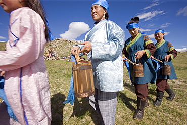
Horse milk is sprinkled into the four directions, as offerings to the nature spirits of the area, the sadak, or ?owners Of the earth.? Sometimes vodka is used instead, or as well. Milk is sacred to the mongol shamans, who believe that life on earth is descended from beings who originally came here on winged horses. Here two young female shamans make the offering in a ritual manner. Countryside mongols make this offering every morning on waking up; they usually also offer smoke, that the wind carries around the world as a prayer for harmony and prosperity. 13th century national park, tov province, mongolia. 13th century national park comprises chinggis khan's giant statue museum and live museum "town from 13 century". The ancient nomadic mini kingdom is located in the distance of 130 km east of ulaanbaatar in area of erdene zuu of tov province. It takes 2 hours driving on paved road. In the live 13th century kingdom one will see and experience the authentic lifestyle of mongols, who were lived in powerful mongol empire?s Period. This place gives you a same feeling that famous traveler marco polo and william rubruck felt once upon time
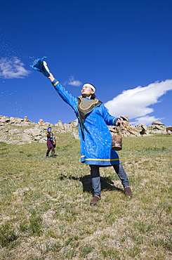
Horse milk is sprinkled into the four directions, as offerings to the nature spirits of the area, the sadak, or ?owners Of the earth.? Sometimes vodka is used instead, or as well. Milk is sacred to the mongol shamans, who believe that life on earth is descended from beings who originally came here on winged horses. Here two young female shamans make the offering in a ritual manner. Countryside mongols make this offering every morning on waking up; they usually also offer smoke, that the wind carries around the world as a prayer for harmony and prosperity. 13th century national park, tov province, mongolia. 13th century national park comprises chinggis khan's giant statue museum and live museum "town from 13 century". The ancient nomadic mini kingdom is located in the distance of 130 km east of ulaanbaatar in area of erdene zuu of tov province. It takes 2 hours driving on paved road. In the live 13th century kingdom one will see and experience the authentic lifestyle of mongols, who were lived in powerful mongol empire?s Period. This place gives you a same feeling that famous traveler marco polo and william rubruck felt once upon time
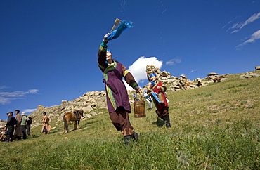
Horse milk is sprinkled into the four directions, as offerings to the nature spirits of the area, the sadak, or ?owners Of the earth.? Sometimes vodka is used instead, or as well. Milk is sacred to the mongol shamans, who believe that life on earth is descended from beings who originally came here on winged horses. Here two young female shamans make the offering in a ritual manner. Countryside mongols make this offering every morning on waking up; they usually also offer smoke, that the wind carries around the world as a prayer for harmony and prosperity. 13th century national park, tov province, mongolia. 13th century national park comprises chinggis khan's giant statue museum and live museum "town from 13 century". The ancient nomadic mini kingdom is located in the distance of 130 km east of ulaanbaatar in area of erdene zuu of tov province. It takes 2 hours driving on paved road. In the live 13th century kingdom one will see and experience the authentic lifestyle of mongols, who were lived in powerful mongol empire?s Period. This place gives you a same feeling that famous traveler marco polo and william rubruck felt once upon time
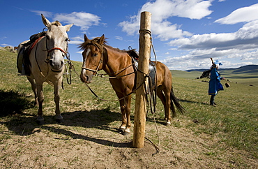
Horse milk is sprinkled into the four directions, as offerings to the nature spirits of the area, the sadak, or ?owners Of the earth.? Sometimes vodka is used instead, or as well. Milk is sacred to the mongol shamans, who believe that life on earth is descended from beings who originally came here on winged horses. Here two young female shamans make the offering in a ritual manner. Countryside mongols make this offering every morning on waking up; they usually also offer smoke, that the wind carries around the world as a prayer for harmony and prosperity. 13th century national park, tov province, mongolia. 13th century national park comprises chinggis khan's giant statue museum and live museum "town from 13 century". The ancient nomadic mini kingdom is located in the distance of 130 km east of ulaanbaatar in area of erdene zuu of tov province. It takes 2 hours driving on paved road. In the live 13th century kingdom one will see and experience the authentic lifestyle of mongols, who were lived in powerful mongol empire?s Period. This place gives you a same feeling that famous traveler marco polo and william rubruck felt once upon time
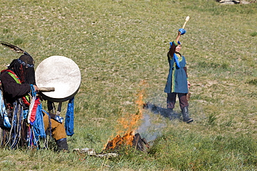
Horse milk is sprinkled into the four directions, as offerings to the nature spirits of the area, the sadak, or ?owners Of the earth.? Sometimes vodka is used instead, or as well. Milk is sacred to the mongol shamans, who believe that life on earth is descended from beings who originally came here on winged horses. Here two young female shamans make the offering in a ritual manner. Countryside mongols make this offering every morning on waking up; they usually also offer smoke, that the wind carries around the world as a prayer for harmony and prosperity. 13th century national park, tov province, mongolia. 13th century national park comprises chinggis khan's giant statue museum and live museum "town from 13 century". The ancient nomadic mini kingdom is located in the distance of 130 km east of ulaanbaatar in area of erdene zuu of tov province. It takes 2 hours driving on paved road. In the live 13th century kingdom one will see and experience the authentic lifestyle of mongols, who were lived in powerful mongol empire?s Period. This place gives you a same feeling that famous traveler marco polo and william rubruck felt once upon time
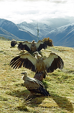
Vultures, drigung. bodies what we most attached to, says of monks. Thats offering ones body carries greatest merit. believe that should benefit other beings at every stage of ones life. After completion of powa ceremony, corpse is traditionally offered to great vultures lammergeiers that frequent charnel grounds. Vultures descend on flayed corpse. Offering bodies to birds is same as reciting mantras. It brings merit benefit to dead person as well as to family friends bring here. While cutting up corpse i to keep a pure compassionate mind. would feel if someone felt cutting up your body. -tomdenla. Tibet
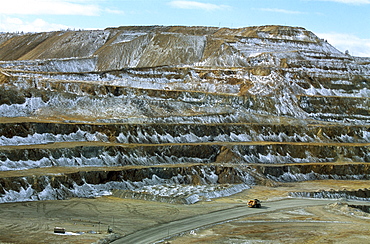
Mongolian-russian mining venture on outskirts of erdenet city, population of 80,000 dictates work as well as life in soviet -style city. 5,200 employees work at this site excavating up to 25.2 million tons of iron year
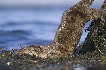
Eurasian river otter (Lutra lutra). Otters in western Scotland have adapted well to life in a marine environment, though proximity to sources of fresh water is essential. Hebrides, Scotland
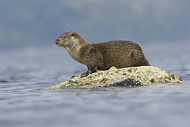
Eurasian river otter (Lutra lutra). Otters in western Scotland have adapted well to life in a marine environment, though proximity to sources of fresh water is essential. Hebrides, Scotland
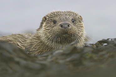
Eurasian river otter (Lutra lutra). Otters in western Scotland have adapted well to life in a marine environment, though proximity to sources of fresh water is essential. Hebrides, Scotland
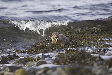
Eurasian river otter (Lutra lutra) eating fish. Otters in western Scotland have adapted well to life in a marine environment, though proximity to sources of fresh water is essential. Hebrides, Scotland
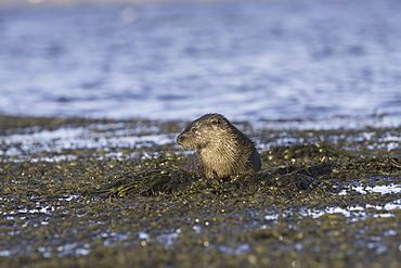
Eurasian river otter (Lutra lutra). Otters in western Scotland have adapted well to life in a marine environment, though proximity to sources of fresh water is essential. Hebrides, Scotland

Eurasian river otter (Lutra lutra). Otters in western Scotland have adapted well to life in a marine environment, though proximity to sources of fresh water is essential. Hebrides, Scotland
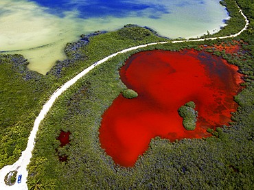
Aerial view of Punta Allen Sian Ka'an Reserve, Yucatan Peninsula, Mexico. Red lagoon near Boca Paila Bridge.
In the language of the Mayan peoples who once inhabited this region, Sian Ka'an means Origin of the Sky. Located on the east coast of the Yucatán peninsula, this biosphere reserve contains tropical forests, mangroves and marshes, as well as a large marine section intersected by a barrier reef. It provides a habitat for a remarkably rich flora and a fauna comprising more than 300 species of birds, as well as a large number of the region's characteristic terrestrial vertebrates, which cohabit in the diverse environment formed by its complex hydrological system.
Along its roughly 120 kilometres of coastline, the property covers over 400,000 hectares of land ranging from sea level to only ten m.a.s.l. The property boasts diverse tropical forests, palm savannah, one of the most pristine wetlands in the region, lagoons, extensive mangrove stands, as well as sandy beaches and dunes. The 120,000 hectares of marine area protect a valuable part of the Mesoamerican Barrier Reef and seagrass beds in the shallow bays. The lush green of the forests and the many shades of blue of the lagoons and the Caribbean Sea under a wide sky offer fascinating visual impressions.
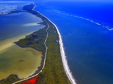
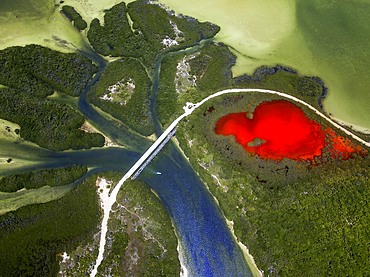

Aerial view of Punta Allen Sian Ka'an Reserve, Yucatan Peninsula, Mexico.
In the language of the Mayan peoples who once inhabited this region, Sian Ka'an means Origin of the Sky. Located on the east coast of the Yucatán peninsula, this biosphere reserve contains tropical forests, mangroves and marshes, as well as a large marine section intersected by a barrier reef. It provides a habitat for a remarkably rich flora and a fauna comprising more than 300 species of birds, as well as a large number of the region's characteristic terrestrial vertebrates, which cohabit in the diverse environment formed by its complex hydrological system.
Along its roughly 120 kilometres of coastline, the property covers over 400,000 hectares of land ranging from sea level to only ten m.a.s.l. The property boasts diverse tropical forests, palm savannah, one of the most pristine wetlands in the region, lagoons, extensive mangrove stands, as well as sandy beaches and dunes. The 120,000 hectares of marine area protect a valuable part of the Mesoamerican Barrier Reef and seagrass beds in the shallow bays. The lush green of the forests and the many shades of blue of the lagoons and the Caribbean Sea under a wide sky offer fascinating visual impressions.
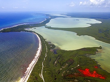
Aerial view of Punta Allen Sian Ka'an Reserve, Yucatan Peninsula, Mexico. Red lagoon near Boca Paila Bridge.
In the language of the Mayan peoples who once inhabited this region, Sian Ka'an means Origin of the Sky. Located on the east coast of the Yucatán peninsula, this biosphere reserve contains tropical forests, mangroves and marshes, as well as a large marine section intersected by a barrier reef. It provides a habitat for a remarkably rich flora and a fauna comprising more than 300 species of birds, as well as a large number of the region's characteristic terrestrial vertebrates, which cohabit in the diverse environment formed by its complex hydrological system.
Along its roughly 120 kilometres of coastline, the property covers over 400,000 hectares of land ranging from sea level to only ten m.a.s.l. The property boasts diverse tropical forests, palm savannah, one of the most pristine wetlands in the region, lagoons, extensive mangrove stands, as well as sandy beaches and dunes. The 120,000 hectares of marine area protect a valuable part of the Mesoamerican Barrier Reef and seagrass beds in the shallow bays. The lush green of the forests and the many shades of blue of the lagoons and the Caribbean Sea under a wide sky offer fascinating visual impressions.

Palms and old pier in Punta Allen Sian Ka'an Reserve, Yucatan Peninsula, Mexico.
In the language of the Mayan peoples who once inhabited this region, Sian Ka'an means Origin of the Sky. Located on the east coast of the Yucatán peninsula, this biosphere reserve contains tropical forests, mangroves and marshes, as well as a large marine section intersected by a barrier reef. It provides a habitat for a remarkably rich flora and a fauna comprising more than 300 species of birds, as well as a large number of the region's characteristic terrestrial vertebrates, which cohabit in the diverse environment formed by its complex hydrological system.
Along its roughly 120 kilometres of coastline, the property covers over 400,000 hectares of land ranging from sea level to only ten m.a.s.l. The property boasts diverse tropical forests, palm savannah, one of the most pristine wetlands in the region, lagoons, extensive mangrove stands, as well as sandy beaches and dunes. The 120,000 hectares of marine area protect a valuable part of the Mesoamerican Barrier Reef and seagrass beds in the shallow bays. The lush green of the forests and the many shades of blue of the lagoons and the Caribbean Sea under a wide sky offer fascinating visual impressions.

Life-size figure of King Arthur, Knight of the Round Table, in front of the Merlin Gifts & Confectionery shop, Fore Street, Tintagel, Cornwall, England, United Kingdom, Europe

Lifesaver fountain by Niki de Saint Phalle and Jean Tinguely, Koenigstrasse, Duisburg, Ruhrgebiet area, North Rhine-Westphalia, Germany, Europe
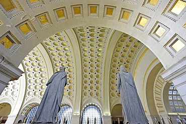
Interior view, Great Main Hall, larger than life statues, waiting room, Union Station, Washington DC, District of Columbia, United States of America
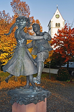
Statue of a dancing couple on a well, surrounded by 23 columns with heads made of bronze, in front of the Catholic Mariae Himmelfahrt Church, Immenstaad, Baden-Wuerttemberg, Germany, Europe
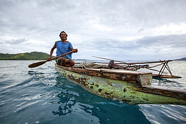
Nimoa Island - here the island mission will impress. The five-sided church features murals of island life and all mission buildings are surrounded by well maintained paths and gardens filled with flowering plants. Edged by jungle-covered mountains, postcard beaches and crystal clear waters - an island paradise indeed! The Louisiade Archipelago is a string of ten larger volcanic islands frequently fringed by coral reefs, and 90 smaller coral islands located 200 km southeast of New Guinea, stretching over more than 160 km and spread over an ocean area of 26,000 km? between the Solomon Sea to the north and the Coral Sea to the south. The aggregate land area of the islands is about 1,790 km? (690 square miles), with Vanatinai (formerly Sudest or Tagula as named by European claimants on Western maps) being the largest. Sideia Island and Basilaki Island lie closest to New Guinea, while Misima, Vanatinai, and Rossel islands lie further east. The archipelago is divided into the Local Level Government (LLG) areas Loui!
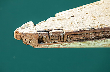
Nimoa Island - here the island mission will impress. The five-sided church features murals of island life and all mission buildings are surrounded by well maintained paths and gardens filled with flowering plants. Edged by jungle-covered mountains, postcard beaches and crystal clear waters - an island paradise indeed! The Louisiade Archipelago is a string of ten larger volcanic islands frequently fringed by coral reefs, and 90 smaller coral islands located 200 km southeast of New Guinea, stretching over more than 160 km and spread over an ocean area of 26,000 km? between the Solomon Sea to the north and the Coral Sea to the south. The aggregate land area of the islands is about 1,790 km? (690 square miles), with Vanatinai (formerly Sudest or Tagula as named by European claimants on Western maps) being the largest. Sideia Island and Basilaki Island lie closest to New Guinea, while Misima, Vanatinai, and Rossel islands lie further east. The archipelago is divided into the Local Level Government (LLG) areas Loui!

Nimoa Island - here the island mission will impress. The five-sided church features murals of island life and all mission buildings are surrounded by well maintained paths and gardens filled with flowering plants. Edged by jungle-covered mountains, postcard beaches and crystal clear waters - an island paradise indeed! The Louisiade Archipelago is a string of ten larger volcanic islands frequently fringed by coral reefs, and 90 smaller coral islands located 200 km southeast of New Guinea, stretching over more than 160 km and spread over an ocean area of 26,000 km? between the Solomon Sea to the north and the Coral Sea to the south. The aggregate land area of the islands is about 1,790 km? (690 square miles), with Vanatinai (formerly Sudest or Tagula as named by European claimants on Western maps) being the largest. Sideia Island and Basilaki Island lie closest to New Guinea, while Misima, Vanatinai, and Rossel islands lie further east. The archipelago is divided into the Local Level Government (LLG) areas Louisiade Rural (western part, with Misima), and Yaleyamba (western part, with Rossell and Tagula islands. The LLG areas are part of Samarai-Murua District district of Milne Bay. The seat of the Louisiade Rural LLG is Bwagaoia on Misima Island, the population center of the archipelago.
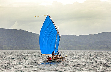
Nimoa Island - here the island mission will impress. The five-sided church features murals of island life and all mission buildings are surrounded by well maintained paths and gardens filled with flowering plants. Edged by jungle-covered mountains, postcard beaches and crystal clear waters - an island paradise indeed! The Louisiade Archipelago is a string of ten larger volcanic islands frequently fringed by coral reefs, and 90 smaller coral islands located 200 km southeast of New Guinea, stretching over more than 160 km and spread over an ocean area of 26,000 km? between the Solomon Sea to the north and the Coral Sea to the south. The aggregate land area of the islands is about 1,790 km? (690 square miles), with Vanatinai (formerly Sudest or Tagula as named by European claimants on Western maps) being the largest. Sideia Island and Basilaki Island lie closest to New Guinea, while Misima, Vanatinai, and Rossel islands lie further east.

Nimoa Island - here the island mission will impress. The five-sided church features murals of island life and all mission buildings are surrounded by well maintained paths and gardens filled with flowering plants. Edged by jungle-covered mountains, postcard beaches and crystal clear waters - an island paradise indeed! The Louisiade Archipelago is a string of ten larger volcanic islands frequently fringed by coral reefs, and 90 smaller coral islands located 200 km southeast of New Guinea, stretching over more than 160 km and spread over an ocean area of 26,000 km? between the Solomon Sea to the north and the Coral Sea to the south. The aggregate land area of the islands is about 1,790 km? (690 square miles), with Vanatinai (formerly Sudest or Tagula as named by European claimants on Western maps) being the largest. Sideia Island and Basilaki Island lie closest to New Guinea, while Misima, Vanatinai, and Rossel islands lie further east. The archipelago is divided into the Local Level Government (LLG) areas Louisiade Rural (western part, with Misima), and Yaleyamba (western part, with Rossell and Tagula islands. The LLG areas are part of Samarai-Murua District district of Milne Bay. The seat of the Louisiade Rural LLG is Bwagaoia on Misima Island, the population center of the archipelago.
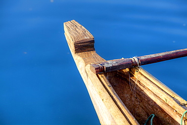
Nimoa Island - here the island mission will impress. The five-sided church features murals of island life and all mission buildings are surrounded by well maintained paths and gardens filled with flowering plants. Edged by jungle-covered mountains, postcard beaches and crystal clear waters - an island paradise indeed! The Louisiade Archipelago is a string of ten larger volcanic islands frequently fringed by coral reefs, and 90 smaller coral islands located 200 km southeast of New Guinea, stretching over more than 160 km and spread over an ocean area of 26,000 km? between the Solomon Sea to the north and the Coral Sea to the south. The aggregate land area of the islands is about 1,790 km? (690 square miles), with Vanatinai (formerly Sudest or Tagula as named by European claimants on Western maps) being the largest. Sideia Island and Basilaki Island lie closest to New Guinea, while Misima, Vanatinai, and Rossel islands lie further east. The archipelago is divided into the Local Level Government (LLG) areas Louisiade Rural (western part, with Misima), and Yaleyamba (western part, with Rossell and Tagula islands. The LLG areas are part of Samarai-Murua District district of Milne Bay. The seat of the Louisiade Rural LLG is Bwagaoia on Misima Island, the population center of the archipelago.
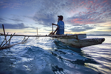
Nimoa Island - here the island mission will impress. The five-sided church features murals of island life and all mission buildings are surrounded by well maintained paths and gardens filled with flowering plants. Edged by jungle-covered mountains, postcard beaches and crystal clear waters - an island paradise indeed! The Louisiade Archipelago is a string of ten larger volcanic islands frequently fringed by coral reefs, and 90 smaller coral islands located 200 km southeast of New Guinea, stretching over more than 160 km and spread over an ocean area of 26,000 km? between the Solomon Sea to the north and the Coral Sea to the south. The aggregate land area of the islands is about 1,790 km? (690 square miles), with Vanatinai (formerly Sudest or Tagula as named by European claimants on Western maps) being the largest. Sideia Island and Basilaki Island lie closest to New Guinea, while Misima, Vanatinai, and Rossel islands lie further east. The archipelago is divided into the Local Level Government (LLG) areas Loui!
