Results
« Previous 1 … 9 10 11 12 13 … 39 Next »
3846 results found
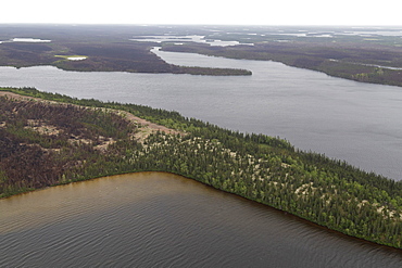
Aerial photography of an esker, a sandy ridge formed by subglacial deposits of sediment in the last Ice Age, in Manitoba, Canada, North America
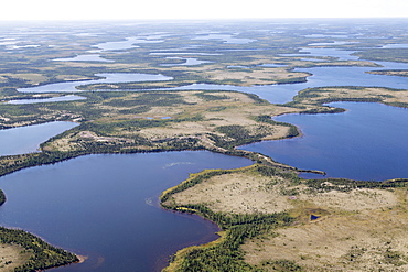
Aerial view of lakes and an esker, a ridge formed by sediment deposited during the last Ice Age, in northern Manitoba, Canada, North America
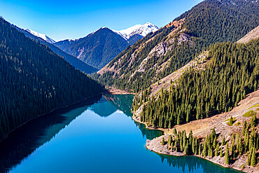
Aerial of the Lower Kolsai Lake, Kolsay Lakes National Park, Tian Shan mountains, Kazakhstan, Central Asia, Asia
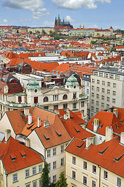
Aerial view over the red roofs of Prague, the Castle and the Cathedral, UNESCO World Heritage Site, Prague, Bohemia, Czech Republic (Czechia), Europe

Aerial view from the top of Sun Island across deep blue Lake Titicaca to the mainland, Bolivia, South America
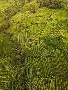
Aerial view of Jatiluwih Rice Terraces, Tabanan, Bali, Indonesia, Southeast Asia, Asia

Aerial view from Tanah Lot Temple, Bali, Indonesia, Southeast Asia, Asia
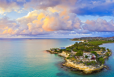
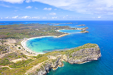
Aerial panoramic by drone of Fort James, St. John's, Antigua, Leeward Islands, West Indies, Caribbean, Central America

White limestone cliffs Pillar of Hercules washed by Caribbean Sea, aerial view by drone, English Harbour, Antigua, Leeward Islands, West Indies, Caribbean, Central America

Aerial panoramic by drone of the coral reef around Long Bay, Antigua, Antigua and Barbuda, Leeward Islands, West Indies, Caribbean, Central America
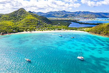
Aerial view by drone of Hermitage Bay and Caribbean Sea, Antigua, Antigua and Barbuda, Leeward Islands, West Indies, Caribbean, Central America
Aerial panoramic by drone of Galleon Beach and Pillar of Hercules limestone cliffs, Antigua, Antigua and Barbuda, Leeward Islands, West Indies, Caribbean, Central America
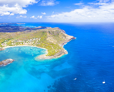
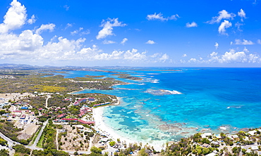
Aerial view by drone of cliffs surrounding Half Moon Bay washed by Caribbean Sea, Antigua, Leeward Islands, West Indies, Caribbean, Central America
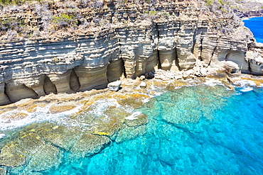
White limestone cliffs Pillar of Hercules washed by Caribbean Sea, aerial view by drone, English Harbour, Antigua, Leeward Islands, West Indies, Caribbean, Central America
Aerial panoramic by drone of coral reef along Long Bay beach, Antigua, Antigua and Barbuda, Leeward Islands, West Indies, Caribbean, Central America
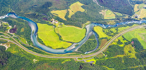
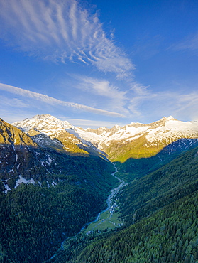
Aerial view of Rauma river and green valley from Romsdalseggen ridge, Andalsnes, More og Romsdal county, Norway, Scandinavia, Europe
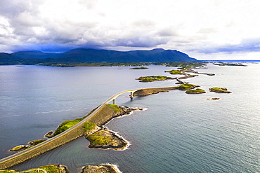
Aerial view of Storseisundet Bridge surrounded by sea and islets, Atlantic Road, More og Romsdal county, Norway, Scandinavia, Europe
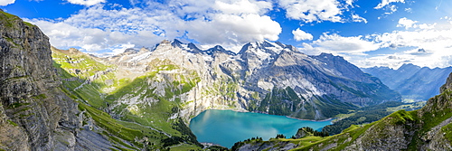
Aerial panoramic of Oeschinensee lake surrounded by woods in summer, Bernese Oberland, Kandersteg, Canton of Bern, Switzerland, Europe
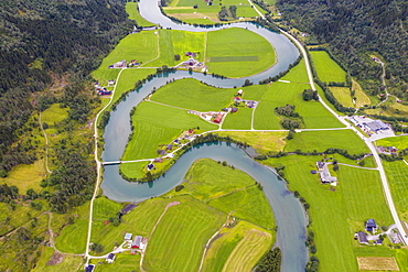
Aerial view of the winding course of Stryneelva river, Stryn, Nordfjorden, Sogn og Fjordane county, Norway, Scandinavia, Europe

Aerial view of man lying down along the bends of historic Vindhellavegen road, Borgund, Laerdal, Sogn og Fjordane county, Norway, Scandinavia, Europe
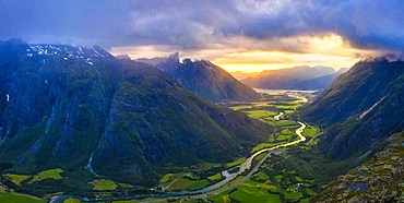
Aerial view of clouds at sunset over Romsdalen valley from Romsdalseggen ridge, Andalsnes, More og Romsdal county, Norway, Scandinavia, Europe

Aerial view of sun rays at sunset lighting up the clouds over Romsdalen valley, Andalsnes, More og Romsdal county, Norway, Scandinavia, Europe
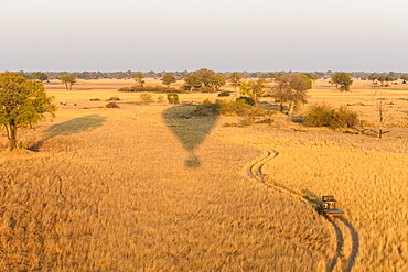
Aerial view of the Okavango Delta from a hot air balloon ride including chase vehicle, Okavango Delta, Botswana, Africa
Aerial view of African buffalo (Cape Buffalo) (Syncerus caffer), Macatoo, Okavango Delta, Botswana, Africa

Aerial view of the Okavango Delta seen from a hot air balloon ride, Bushman Plains, Okavango Delta, Botswana, Africa
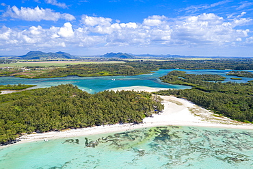
Aerial by drone of white sand beach with turquoise sea surrounded by tropical trees, Ile Aux Cerfs, Flacq, Mauritius, Indian Ocean, Africa
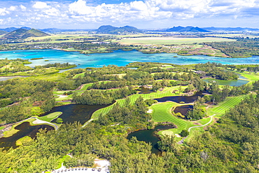
Aerial by drone of golf courses in the lush vegetation of the tropical lagoon, Ile Aux Cerfs, Flacq district, Mauritius, Indian Ocean, Africa
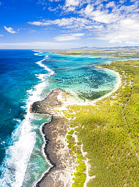
Turquoise coral reef meeting the waves of the Indian Ocean, aerial view, Poste Lafayette, East coast, Mauritius, Indian Ocean, Africa
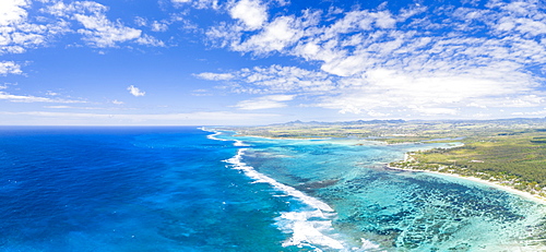
Aerial panoramic of tropical Public Beach washed by the ocean waves, Poste Lafayette, East coast, Mauritius, Indian Ocean, Africa
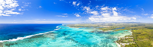
Aerial panoramic of waves of Indian Ocean and turquoise coral reef, Poste Lafayette, East coast, Mauritius, Indian Ocean, Africa

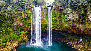
Aerial of the Tamul waterfalls, Huasteca Potosi, San Luis Potosi, Mexico, North America

Aerial of the Tamul waterfalls, Huasteca Potosi, San Luis Potosi, Mexico, North America
Aerial view by drone of Playa los Angeles, Magdalena Department, Caribbean, Colombia, South America
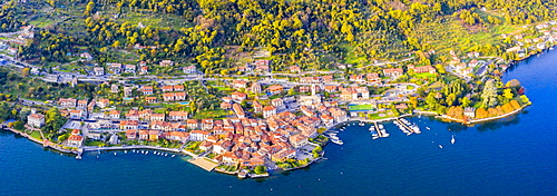
Aerial view of Sala Comacina, Lake Como, Lombardy, Italian Lakes, Italy, Europe
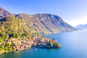
Aerial view by drone of Varenna, Lake Como, Lombardy, Italian Lakes, Italy, Europe
Aerial view by drone of Playa los Angeles, Magdalena Department, Caribbean, Colombia, South America
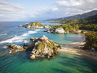
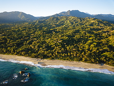
Aerial view by drone of Tayrona National Park, Magdalena Department, Caribbean, Colombia, South America

Aerial view by drone of Tayrona National Park, Magdalena Department, Caribbean, Colombia, South America
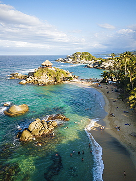
Aerial view by drone of Tayrona National Park, Magdalena Department, Caribbean, Colombia, South America

Aerial view by drone of Playa los Angeles, Magdalena Department, Caribbean, Colombia, South America
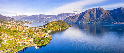
Aerial view of Tremezzina villages in autumn, Lake Como, Lombardy, Italian Lakes, Italy, Europe

Aerial view by drone of Tayrona National Park, Magdalena Department, Caribbean, Colombia, South America
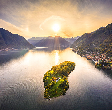
Aerial view of Comacina Island at sunset, Lake Como, Lombardy, Italian Lakes, Italy, Europe
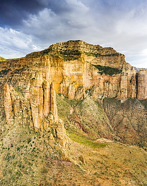
Aerial view of mountains housing Abuna Yemata Guh church carved in rocks, Gheralta Mountains, Tigray Region, Ethiopia, Africa

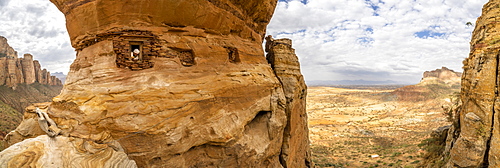
Aerial view of opening carved in rocks, entrance of Abuna Yemata Guh church, Gheralta Mountains, Tigray Region, Ethiopia, Africa
Aerial panoramic by drone of priest looking out from Abuna Yemata Guh rock-hewn church, Gheralta Mountains, Tigray region, Ethiopia, Africa
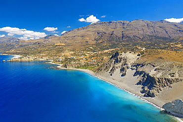
Aerial view of Agios Pavlos Beach on the island of Crete, Greek Islands, Greece, Europe
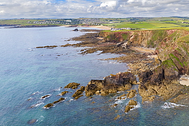
Aerial vista of Thurlestone Bay and village in the South Hams, Devon, England, United Kingdom, Europe
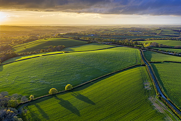
Aerial photo of rolling countryside in evening light, Livaton, Devon, England, United Kingdom, Europe
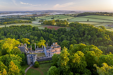
Aerial photograph of Berry Pomeroy Castle at dawn in spring, Devon, England, United Kingdom, Europe
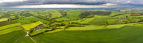
Aerial vista of rolling countryside near the village of Coldridge, Devon, England, United Kingdom, Europe

Early morning aerial panoramic of the River Dart estuary, Stoke Gabriel, South Hams, Devon, England, United Kingdom, Europe
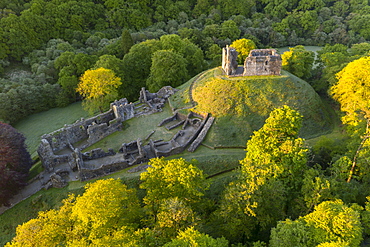
Aerial image showing the ruins of Okehampton Castle on a spring morning, Okehampton, Devon, England, United Kingdom, Europe
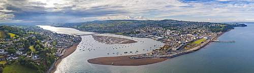
Aerial vista of Teignmouth and the River Teign, Devon, England, United Kingdom, Europe
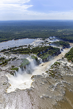
Aerial view of the Devil's Throat and the Iguassu River, Iguazu Falls, UNESCO World Heritage Site, Parana, Brazil, South America

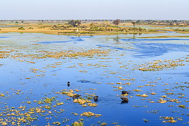
Aerial view of Lake Kariba, the world's largest man-made lake and reservoir by volume, Zimbabwe, Africa

Aerial view of Lake Kariba, the world's largest man-made lake and reservoir by volume, Zimbabwe, Africa

Aerial view of Lake Kariba, the world's largest man-made lake and reservoir by volume, Zimbabwe, Africa
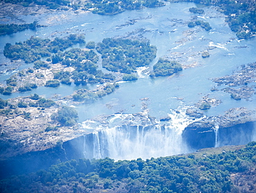
Aerial view of Victoria Falls on the Zambezi River, UNESCO World Heritage Site, straddling the border of Zambia and Zimbabwe, Africa

Aerial view of Victoria Falls on the Zambezi River, UNESCO World Heritage Site, straddling the border of Zambia and Zimbabwe, Africa
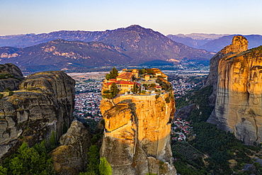
Aerial by drone of the Holy Monastery of Holy Trinity at sunrise, UNESCO World Heritage Site, Meteora Monasteries, Greece, Europe
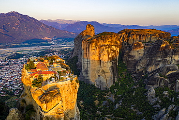
Aerial by drone of the Holy Monastery of Holy Trinity at sunrise, UNESCO World Heritage Site, Meteora Monasteries, Greece, Europe
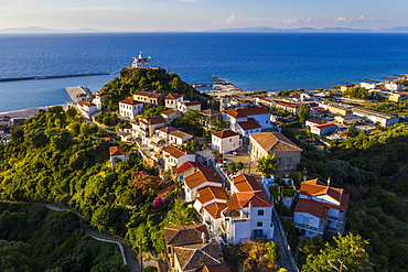
Aerial by drone of Agia Triada church, Paleo Karlovasi, Samos, Greek Islands, Greece, Europe

Aerial by drone over Patmos and the town of Skala, Patmos, Dodecanese, Greek Islands, Greece, Europe
Aerial panoramic of Monte Disgrazia and Chiareggio valley at dawn, Valmalenco, Sondrio province, Valtellina, Lombardy, Italy, Europe

Aerial view by helicopter of Iguacu Falls (Cataratas do Iguacu), UNESCO World Heritage Site, Parana, Brazil, South America
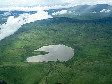
Aerial view of Ngorongoro Crater in the Ngorongoro Conservation Area, UNESCO World Heritage Site, Tanzania, East Africa, Africa
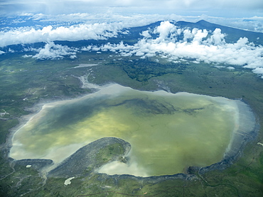
Aerial view of Ngorongoro Crater in the Ngorongoro Conservation Area, UNESCO World Heritage Site, Tanzania, East Africa, Africa
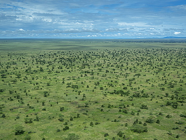
Aerial view of the Serengeti Plains, Serengeti National Park, UNESCO World Heritage Site, Tanzania, East Africa, Africa
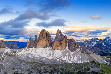
Aerial view of Tre Cime di Lavaredo and Grava Longa lakes at sunset, Sesto Dolomites Natural Park, South Tyrol, Italy, Europe
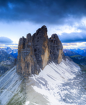
Clouds over the majestic peaks of Tre Cime di Lavaredo, aerial view, Sesto Dolomites Natural Park, South Tyrol, Italy, Europe
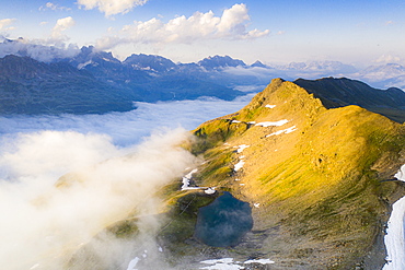
Schwarziseeli lake and Stotzigen Firsten mountain emerging from a sea of clouds, aerial view, Furka Pass, Canton Uri, Switzerland, Europe
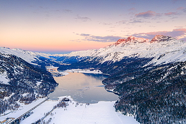
Aerial view of frozen Lake Silvaplana and Piz Corvatsch covered with snow at sunset, Engadine, Graubunden canton, Swiss Alps, Switzerland, Europe

Aerial panoramic of Lake Como and Varenna at sunset, Lecco province, Lombardy, Italian Lakes, Italy, Europe
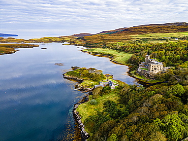
Aerial of Dunvegan Castle, Isle of Skye, Inner Hebrides, Scotland, United Kingdom, Europe
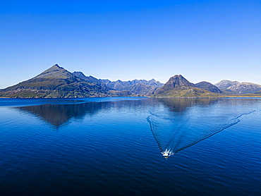
Aerial of the Black Cuillin ridge, Elgol, Isle of Skye, Inner Hebrides, Scotland, United Kingdom, Europe
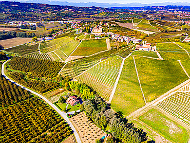
Aerial of the vineyards around Castle of Grinzane Cavour, Barolo wine region, UNESCO World Heritage Site, Piedmont, Italy, Europe
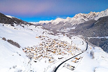
Mountain road crossing the village of Ardez covered with snow, aerial view, Engadine, Graubunden Canton, Switzerland, Europe
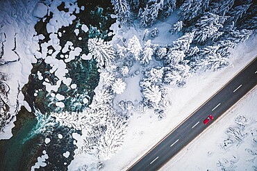
Car traveling on the snowy mountain road on side of frozen river and woods, aerial view, Switzerland, Europe
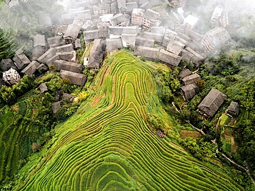
Aerial view on Longsheng rice terraces, also knows as dragon's backbone due to their shape, Guangxi, China, Asia

Aerial view of Longsheng rice terraces, also knows as dragon's backbone due to their shape, Guangxi, China, Asia
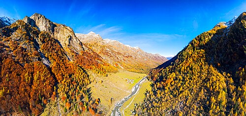
Panoramic aerial view of Val Bodengo during autumn, Valchiavenna, Valtellina, Lombardy, Italy, Europe
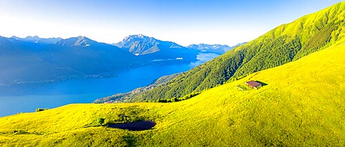
Aerial view of high pasture above Lake Como, Musso, Lake Como, Lombardy, Italian Lakes, Italy, Europe
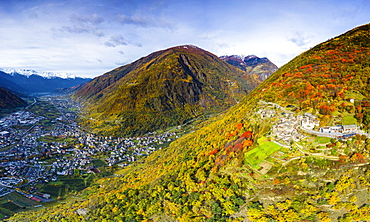
Aerial view of traditional village, Valtellina, Lombardy, Italy, Europe
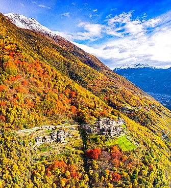
Aerial view of traditional village, Valtellina, Lombardy, Italy, Europe
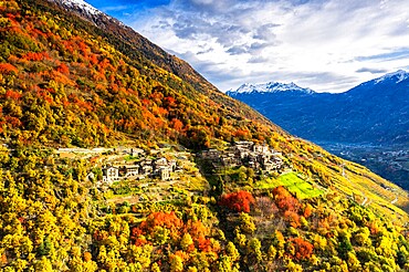
Aerial view of traditional village, Valtellina, Lombardy, Italy, Europe
Aerial of Misol Ha waterfall, Chiapas, Mexico, North America
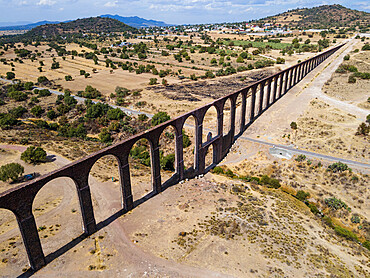
Aqueduct of Padre Tembleque, UNESCO World Heritage Site, Mexico state, Mexico, North America
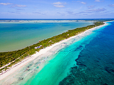
Aerial of Sian Ka'an Biosphere Reserve, UNESCO World Heritage Site, Quintana Roo, Mexico, North America
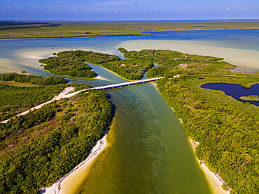
Aerial of Sian Ka'an Biosphere Reserve, UNESCO World Heritage Site, Quintana Roo, Mexico, North America
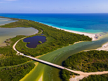
Aerial of Sian Ka'an Biosphere Reserve, UNESCO World Heritage Site, Quintana Roo, Mexico, North America
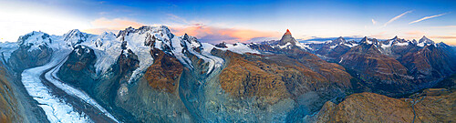
Aerial view of Gorner Glacier (Gornergletscher) and Matterhorn at dawn, Zermatt, canton of Valais, Switzerland, Europe

Aerials from the Tenere desert between Bilma and Fachi, Niger, West Africa, Africa
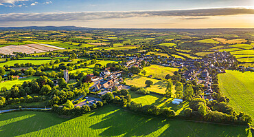
Aerial vista of the rural village of Morchard Bishop in summer, Devon, England, United Kingdom, Europe
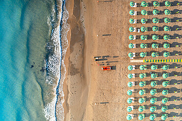
Aerial view of beach umbrellas and sunbeds in tidy rows during summer, Vieste, Foggia province, Gargano, Apulia, Italy, Europe
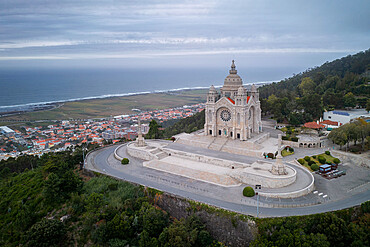
Santa Luzia Church sanctuary, drone aerial view, Viana do Castelo, with Atlantic Ocean in the background, Norte, Portugal, Europe
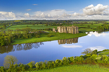
Aerial view of Carew Castle reflected in the mill pond on a still spring morning, Pembrokeshire Coast National Park, Wales, United Kingdom, Europe
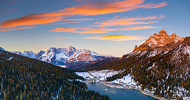
Sunrise over the snowy woods surrounding Lake Misurina and Sorapis, aerial view, Dolomites, Belluno province, Veneto, Italy, Europe
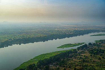
Aerial of the White Nile, Juba, South Sudan, Africa
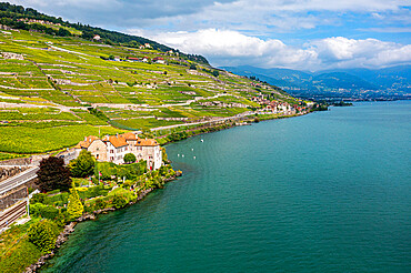
Aerial of the Lavaux Vineyard Terraces, UNESCO World Heritage Site, Lake Geneva, Switzerland, Europe